


Trampers can often be found drooling over maps as they search for the next big trip, but are paper maps becoming a thing of the past?
Three months after the February 22 Christchurch earthquake in 2011, Madeleine Rayner could be found silently weeping over maps.
As she walked around the devastated premises of what was MapWorld, New Zealand’s largest specialist map and navigation store, Rayner, the store manager, would find ruined and irreplaceable historical maps.
It was three months after the quake before shop staff were permitted to re-enter the store in the red zone, on the corner of Manchester and Gloucester Streets.
In those three months water and dust ruined what the quake didn’t. The store’s complete set of topo260 series, its inch to mile collection, globes, atlases and wall maps – all its stock – was destroyed.
What’s worse, it was also uninsured.
As she explains the losses, her voice wavers and the grief surfaces.
Like for so many Cantabrians, the quake isn’t something in the past for Rayner; its impact remains an everyday part of life.
“It’s difficult to get over the fact your entire city has been completely destroyed,” she says with a note of bitterness. “A guy was killed right outside the store – it’s been pretty horrific really.”
After getting over the initial shock of the quake, store owner Neville Jones and Rayner decided to give the business another shot and reopened it on Moorhouse Ave, on the edge of the city centre.
One of their suppliers heard they’d lost everything and sent boxes of maps so they could get going again.
The new premises is a third the size of the previous one and Rayner is now much more cautious about how much stock she orders because there isn’t enough space for everything the old store had.
And, since the quake, demand has dropped through the floor, she says.
Pre-quake, Rayner says the business was humming along. Its handy central location meant some customers would visit the store every week if not to buy, then to browse over the splendour of countless maps.
“Until I came into the business I hadn’t realised there were so many what we call mapoholics in the world,” Rayner says. “If a new series of maps were out, one guy would get them all and wallpaper an entire room in his house.
“He might decide one month it was going to be the 1:200,000 scale maps so he’d buy them all and put them up on the wall and study them.
“He is just one of those people who really, really love maps. There are lots of them.”
Just a couple of months ago Rayner stuck together and laminated a series of topographic maps to cover a 10m by 10m display wall in a customer’s holiday home.
“I put them all together and made them into one giant map and then the customer came back to me and said it wasn’t big enough and needed to include another section as well.”
Mapoholics come in all shapes and sizes and not all of them are outdoors types. Some like to collect maps because they get off on learning place names or are fascinated by some other detail. Others are geographers of one type or another. Some just like to look at them as a form of escape. Some people make art out of them.
Whatever their fancy, mapoholics are the bread and butter of any map retailer.
However, like for so many other retailers, the internet has changed the game. Rayner says map stores around the world are closing down. Australia used to have 10, now four remain. The US once had a map store in nearly every shopping mall, but no longer.
A high proportion of consumers now buy maps online or use digital mapping platforms.
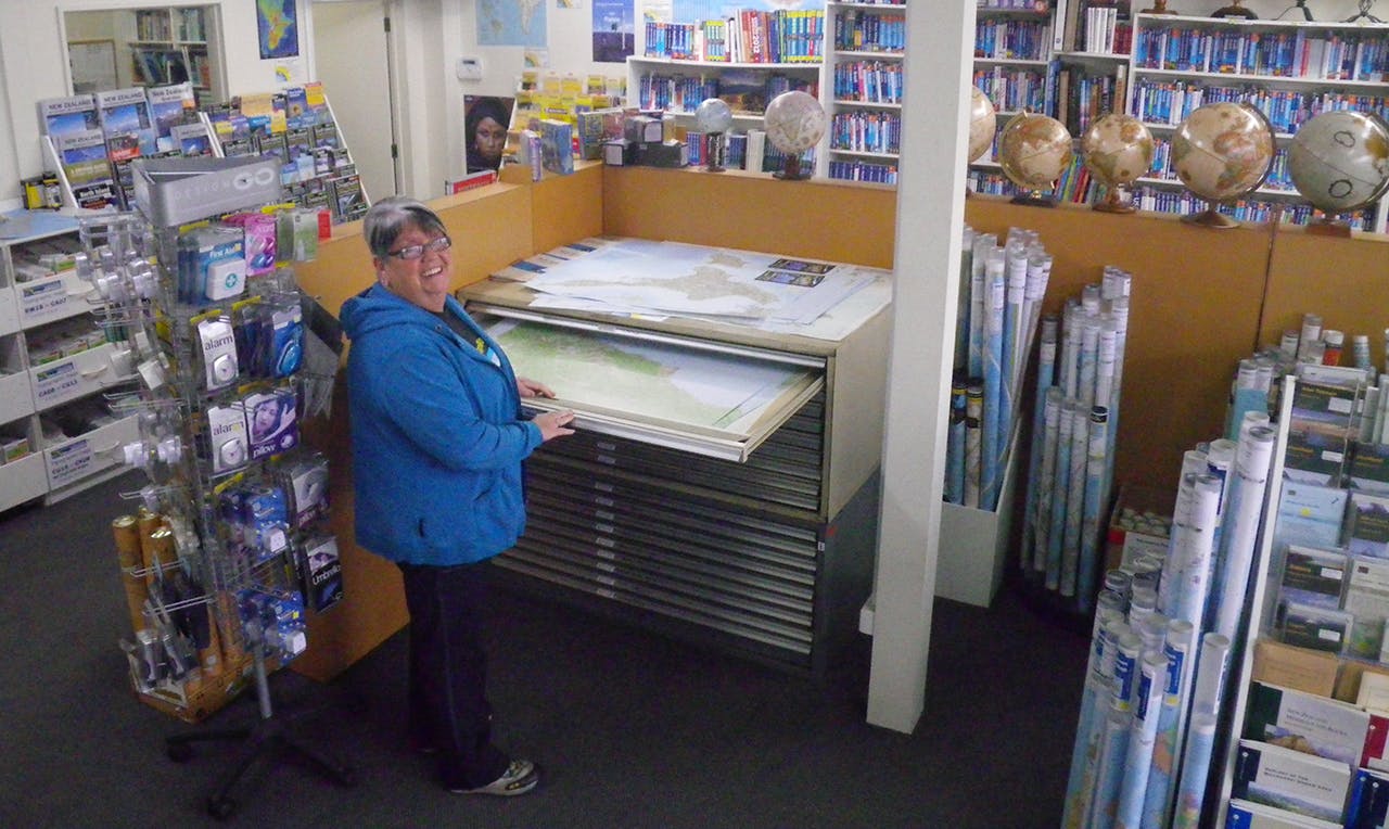
Madeleine Rayner of MapWorld deals with mapoholics every day. Photo: Supplied
The volume MapWorld sells has also decreased, but Rayner isn’t sure whether it’s because of the store’s new location, because of the quake or because customers are getting them elsewhere.
“I can’t make any conclusions yet because so much has changed and so rapidly, but I don’t think overall demand for topo maps has dropped off,” she says. “Although a lot of our customers have digital maps, they always tell us you can’t beat a full size map.
“There is still a demand and I think there will always be a demand [for paper topo maps].”
Land Information New Zealand’s (LINZ) Chris Kinzett agrees.
Kinzett is the team manager for mapping at LINZ’s National Topographic Office. He says his counterparts in Australia are envious of the number of maps LINZ sells every year.
When LINZ released the Topo50 series in 2009, it distributed 300,000 maps the following year. Since then, annual sales have steadily decreased to an average now of 70,000 to 75,000 a year. This is around 17-20 per cent less than map sales 10 years ago.
However, despite the decrease, LINZ’s current average for topo map sales is still high when compared to other countries.
“There’s been quite a bit of talk over the last two or three years that the era of the printed map is dead,” Kinzett says. “However, we don’t believe that. Quite often people who say that, have no real knowledge of what a map is and why it’s used.”
Kinzett and others have been hearing rumours that LINZ is considering ending the production of paper maps. Rayner, for example, says she did a market research phone interview with LINZ recently and the questions she was asked led her to believe an end to paper map production was on the cards.
Kinzett, however, says this is definitely not the case.
LINZ is looking at the cost of offset printing and warehousing maps which Kinzett says is high, especially for low demand maps.
Offset printing is one of the most common forms of printing and essentially boils down to printing in bulk from a plate to a rubber blanket, then to paper. Kinzett predicts in the future LINZ will use a mix of offset printing for high demand maps, nearly all of the backcountry, and a digital, on-demand printing service for low demand maps.
He acknowledges overall sales have dropped, but not so low LINZ is planning to stop producing them.
The rumours about the end of LINZ doing paper maps stem, says Kinzett, from notions of a “futuristic paperless society” and the increasing use of digital and smart devices.
But while the decrease in paper map sales is in part due to the advent of digital mapping, Kinzett believes the impact hasn’t been as great as many people predicted.
The way he sees it, overall map use is increasing – only through a greater variety of media and platforms. And this is a good thing.
In fact, people who are unfamiliar with paper topo maps often become interested in them after using online maps.
“They quite like what they see online so they go and buy the paper version which is always better for planning and won’t fail them in the hills because of a battery [running out],” Kinzett says. “It’s all about making the data available for the wider benefit of the community.
“If people can get accurate map data then they’re less likely to get themselves into problems. That’s the theory behind it.”
One of the most important dates in the history of mapping in New Zealand was in 1996, the year LINZ was formed, when the Government decided to make its topo source data for the entire country available to the public at the cost of dissemination which at that time was $1500. Now it’s free. Prior to this, the Government charged $2million for the data.
Mapping and cartographic design company Geographx’s owner Roger Smith, for example, acquired his first New Zealand topo map data from a US university.
The Department of Survey and Land Information (DOSLI) had made the data available to the US military, but it had since become obsolete. The US then put the data into the public domain without seeking permission from DOSLI.
“I remember being warned by people when I downloaded this data to keep quiet about where I got it from, which was really bizarre,” Smith says. “It wasn’t even very good data.”
The Government’s decision to give the public free access to its map data was a game changer and ultimately led to a profusion of third parties producing maps of various kinds.
Globally, New Zealand was seen as a pioneer for freeing its data up and Smith says many benefits have followed, including the financial viability of starting Geographx.
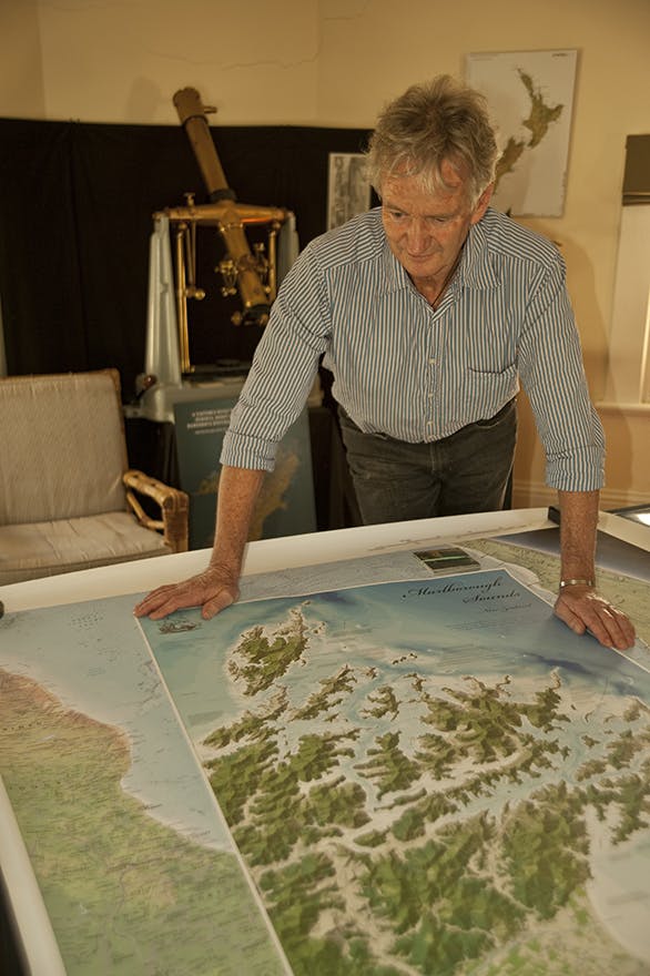
Geographx’s Roger Smith says LINZ should focus on maintaining and updating map data rather than printing maps. Photo: Shaun Barnett / Black Robin Photography
Smith believes the most important role for LINZ is updating and maintaining the geographic information data rather than producing paper maps. However, he readily acknowledges LINZ Topo50 maps remain the best for off-track, backcountry travel.
“You don’t want to get limited by talking about paper versus digital maps because I just see it as us now having more options of how to present maps,” Smith says. “I personally have great confidence in the future of paper maps, but I think there is going to be much more emphasis on doing what they do particularly well.
“You can only get so much on a piece of paper after all.”
For Smith, this means maps should communicate information and have atheistic appeal. Different types of maps have different objectives, but they all should be successful in terms of both function and form.
Digital maps will undergo the most advances in terms of functionality – the ability to layer, query and manipulate – but paper maps hold promise of advancement in atheistic appeal and legibility.
Smith believes the geographic information system (GIS) industry has paid too little heed to communication and as a result topo maps are difficult for the average lay person to understand.
GIS is about capturing, storing, analysing and manipulating geographic data, cartography is the art of communicating it. It’s all about visual communication and graphic design.
And that’s where Geographx is finding its niche. The company produces the 3D range maps published in each issue of Wilderness and is currently working on a new series of 3D maps of New Zealand’s Great Walks for the Department of Conservation.
Still under development, Wilderness got a sneak peak of the new series and can confirm they take map presentation to a new level.
“My thinking about paper maps now is that they should help in the planning [of a trip] and be something that is of use during the experience, but then also be a keepsake after the event,” Smith says. “It’s also about aesthetics; if you want to collect anything tangible, you want it to be a thing of beauty.
“Maps that don’t look nice, that you wouldn’t put on your wall, won’t be around for long.”
Concern for presentation is also what made retired cartographer Geoff Aitken start his business NewTopo. Aitken began his cartography career when, as a boy scout, he went after the map-making badge. He drew a map of his neighbourhood which turned out well. He had both the patience and the drawing ability necessary to be a cartographer. He then did some maps of the headwaters of the Rakaia River and Arthur’s Pass. One thing lead to another and in 1960, DOSLI hired him as a cartographer.
Aitken believes the 2009 Topo50 series are world class maps. However, he’s disappointed they’re not better still. As far as he’s concerned, the series is “a bit bland”.
With more experienced and qualified cartographers who were willing to be more adventurous in their approach, he believes LINZ could have produced a topo series that would have made it a world leader.
At the time LINZ was looking at doing the new series, Aitken tried to convince its staff to create a more interesting and expressive graphic for the maps. LINZ consulted its stakeholders and was told they didn’t want change.
That’s what led Aitken to tinkering with his own maps.
“There is a difference of 30 years in the technologies that the 260s (produced in 1977) were made with and what was available in 2009 and in that time computer graphics improved tremendously,” he says. “Topo50s have retained their accuracy and it’s getting better and better, but I’m not pleased the opportunity wasn’t taken to improve the graphics.”
Aitken says many people are unaware that the Topo50 series was almost all based on mapping recycled from the 260 series.
The new series utilised the old topo mapping in a new format on the new projection and datum.
“I was looking at a map of Whangapeka the other day and the information on it is virtually the same as was published in 1978,” Aitken says. “People aren’t aware of that.
“They see 2009 and think it’s a new edition, that it must be right, but the information on it, about 98 per cent of it, is from 1978.”
The changes gave Aiken an opportunity to publish small-format maps focused on tracks to encourage people to get out walking.
NewTopo has developed over seven years and now includes a series of more than 30 maps, many of them large format.
Since he started the business in 2005, total annual sales have increased by 1100 per cent, providing further proof demand for paper maps is strong.
Aitken puts his success down to a lack of competition, having a good distribution network and having the right product at the right time. More than 50 years of cartography experience also helps.
Roger Smith’s Geographx produces relief shading for Aitken’s NewTopo series to give the illusion of 3D which he says always beats flatter looking maps.
Looking to the future, Aitken hopes synthetic paper materials become cheaper so more durable topo maps can be made with them.
“I am convinced there will always be a demand for paper maps regardless of developments in electronic technologies,” he says.
Top 10 selling Topo50 maps
CB09F – Hollyford
CA11F – Aspiring Flats
BV20F – Otira
BP33F – Featherston
BJ29F – Mount Taranaki or Mount Egmont
BS24F – Mount Robert
BX15F – Fox Glacier
BG40F – Waikaremoana
CB10F – Glenorchy
BZ12F – Makarora
BJ34F – Mount Ruapehu
