


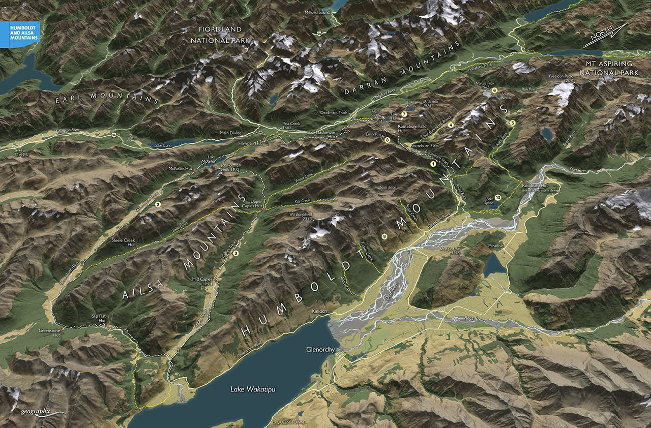

This duo of ranges, the Humboldt and Ailsa mountains, in Fiordland National Park are famous among mountain lands in New Zealand. With the Routeburn and Greenstone-Caples tracks cutting through their length and breadth, as well as the position of the ranges between the Milford Road and the head of Lake Wakatipu, you can be sure that almost anywhere you tread here will be a much heralded experience.
1. Routeburn Track
After the Milford Track this Great Walk is the nation’s most famous walk, and so it should be – it’s a wonderland of waterfalls, lakes, steep peaks, deep forests, grand huts, and breath-stopping views. Either as a full three-day walk or even as a day trip the scenery is remarkable.
2. Greenstone Track
Often used as an add-on or exit point for the Routeburn Track, the Greenstone Track takes hikers down this easy but very beautiful valley to the head of Lake Wakatipu. Spacious valley flats, large huts, and easy riverside tracks make this an easier walk to the Routeburn.
3. Caples Track
The Caples River joins the Greenstone not far above where the latter empties into Lake Wakatipu and therefore provides a new and adventurous return route back to Lake McKellar in the Greenstone Valley. With a little forward planning, the Routeburn, Greenstone and Caples tracks could be walked in little more than a week.
4. Route Burn North Branch
This is where some of the majestic wilderness of these mountain ranges begins. With entry to the North Branch of the Route Burn at Routeburn Flats, all the crowds of walkers, helicopters and intrusions can be left behind as you journey into the heart of the Humboldt Mountains and onto the Main Divide.
5. Rock Burn Valley
A sister valley of the Route Burn, the Rock Burn lies east of the Humboldt Mountains and has an excellent track into its headwaters where Park Pass can be crossed on the Main Divide to access the Olivine country.
6. Lake Nerine and Nereus Peak
Between the Route Burn North and Park Pass is the alpine jewel of Lake Nerine, a deep black lake nestled in an amphitheatre beneath Nereus Peak and draining into the Rock Burn. The lakelet has an isolated and dramatic setting on the Main Divide at the extreme head of the Humboldt Range.
7. Lakes Harris and Wilson
These alpine lakes, one lying beside the Routeburn Track, the other sheltered in a remote basin 1.5km north of Lake Harris beneath Mt Erebus, are worthy of exploration and can be linked via the Valley of the Trolls which drains Lake Wilson, or via the Main Divide.
8. Emily Pass
A high, moderately difficult alpine pass, standing above the head of Lake MacKenzie on the Routeburn Track it offers an opportunity for a return route back to Routeburn Flats. The pass and route are unmarked and require good navigational skills.
9. Eastern Humboldt Mountains
Three tracks climb from the lower Dart Valley high onto the flanks of the Humboldt Mountains and thereby grant access to some of the alpine cirque and peaks here. Scott Creek accesses Scott Hut, Scott Basin, and Kay Creek; Turner Creek, and Glacier Burn grant access to Mt Bonpland.
10. Lake Sylvan
Near the mouth of the Route Burn is one the ranges’ easier tramping trips – beautiful bush-enclosed Lake Sylvan. The lake basin is home to large numbers of native birds and just north of here is the rustic Rock Burn Hut.
