


Third time proves a charm for a group of trampers keen to snare an elusive Westland peak
My altimeter registers 1050m as we clear the bush edge on Scotty’s Ridge in the Taipo Valley in central Westland. We’ve been climbing for nearly three hours from the lower valley, where we stashed my ute after a fairly rough drive from the Arthur’s Pass highway on what has become a road suitable for 4WD vehicles only.
Not owning one, Fr Antoine Thomas and I were forced to take the gravel strip very carefully and managed to negotiate our way well up the lower flats until an impassable ford on a side stream barred further progress.
With boots and packs on, we were off on my third attempt to climb Tara Tama, a remote, seldom-climbed 1854m outlier of the Main Divide. Eighteen hundred metres is not high by Southern Alps standards, but considering the starting altitude is a modest 200m and that the summit lies more than 10km away over a tortuous ridge crest it’s a reasonable challenge.
Although there is an old, roughly marked track to the bush edge, finding it, and the compulsory ford of the Taipo River, often thwarts parties at the very start of the adventure, that and the cloud cover that often hugs the high ridges here for days make progress difficult and sometimes dangerous. The Taipo is not to be trifled with, it’s a big river which drains a massive area of western Arthur’s Pass National Park and often carries substantial volumes of water. We manage it with relative ease this time, unlike my last visit when we looked in vain for a safe passage and eventually had to retreat with neither a peak nor a good round trip to show for our efforts.
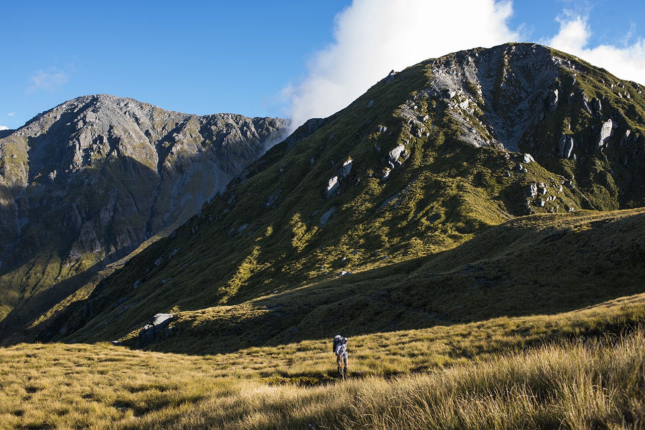
Beyond the bushline on Scottys Ridge we are faced with six kilometres of meandering skyline traverse, all the way to Scottys Saddle and its tiny two-bunk bivvy, sited more than 200m below the crest in the head of Scottys Creek. We will either have to camp on the ridge or drop off into the basin below. Losing hard-won altitude is not a pleasant prospect, but for now we are just intent on following the ridge top.
A superb Westland day is unfolding on our journey, with the peaks and valleys of the Taipo, Taramakau and Lake Brunner region filling the landscape with their craggy profiles and wresting our eyes from the trek ahead. The tramp has become a grand sortie above the plains where spays of tussock, rock and scrub, cloud and a parchment blue sky colour our way. The ridge is not easy, though it never pokes much above 1400m, three large knobs rise on its back like giant vertebrae and slow progress as we crawl over them and into the deep depressions beyond. At times the crest is narrow and rocky, bluffed and rent by faults, at other times it’s wide and spacious and pitted with small tarns. However you cut it, travel is slow but never tedious, there’s too much variety for that. And for inspiration; at the very end of the ridgeline, beyond the bivvy site, sits the great rocky wedge of Tara Tama, rising on clouds of noon.
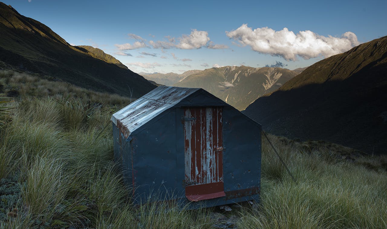
Scotts Bivvy, below Tara Tama. Photo: Pat Barrett
It seems impossibly far away, too steep and too high, but as we get closer our options for breaching the summit bluffs are revealed. By early evening we are still heading south-west to the saddle below the summit, cloud lies to seaward where a steady breeze is stacking caps of billowing vapour onto the lower ridges and forcing arrowheads of cloud up the valleys. Russet tones are seeping into the tussock faces as the sun begins its decline to the sea, pulling deep shadows up the valleys below us. We need to descend to the bivvy, before darkness covers the route. We flounder down the bluffs and scrub to the basin where it lies.
The descent, though unmarked, is reasonable and requires a minimum of bashing through scrub and over steep rocky ribs to access the large bench and its welcome little bivvy-box. Scottys Bivouac is a marvellous sight – rough, wind-scorched, dented here and there, but weatherproof and offering two small bunks and a squab of foam each to rest on for the night.
The hut book reveals that we are the first party in almost a year to unlatch the bolt and crouch inside. For all its spartan comfort, there is no better place to be after a hard day in the hills and as light recedes and night fills the void. The long v-shaped funnel of Scottys Creek draws our eyes down to the Taipo Valley peaks and onto a cusp of moon drifting over the ridge.
The simple pleasure of a restful night in the hills after a good meal cooked in the moonlight is not lost on either of us, that and the tranquillity of high places which rarely see the passage of adventurers. Tomorrow, the adventure begins anew.
To save time next day, we elect to descend into the head of the creek, through scattered scrub, and push upwards over an easy-angled face toward a large basin north-west of the summit, still 800m above us. It’s a tiring route but we are emboldened by the rising sun and the rich tapestry of colour spreading up the valley and lighting the great rippled face of Tara Tama.
At 1300m we gain the basin and surprise a pair of chamois on the bluffs above, their sleek forms race across the cliffs and disappear over the crest. We choose a direct line to the summit ridge from the basin, planning to gain it just east of the low peak, however it’s not done without some difficulty. The upper slopes are steeper than they would appear from below and some brief moments of scratching through shallow gullies and over small rock steps ensues until we cast ourselves up onto the summit ridge. Whoa, what a view from here, we gasp when we pause to take stock. It’s Westland arrayed below – inexpressibly magnificent.
Gaping at the scene around us we soon focus on the summit, barely 700m away and just 150m higher. But there appears to be a sting in the tail of Tara Tama – a gap-toothed ridge forms the route. A short recce shows promise so we head on, rather dubiously. The prospect of returning down the long ridge we have come up is not a pleasant thought and we plan to traverse the summit and exit via steep gullies out to the south. With hearts in our mouths we tread carefully over the rocky crest but as it turns out the towers and gaps are passed with ease. The rock broadens into a pile of scattered blocks easing back to a broad summit, complete with snow-cap to the south. It’s taken us almost 15-hours to reach the top from the Taipo and unbeknown to us at this point, a further 10 hours will pass, and an unplanned night, to reach the ute once more.
For now it’s time to celebrate and Antoine, the parish priest at St Teresa of Lisieux Parish in Riccarton offers Mass on the summit, no doubt the first to do so in all of history. Lunch follows, photos, and a quick phone call home to share the news of the summit and our concerns – midday on day two and we have only just made the summit; it could be a very late return tonight.
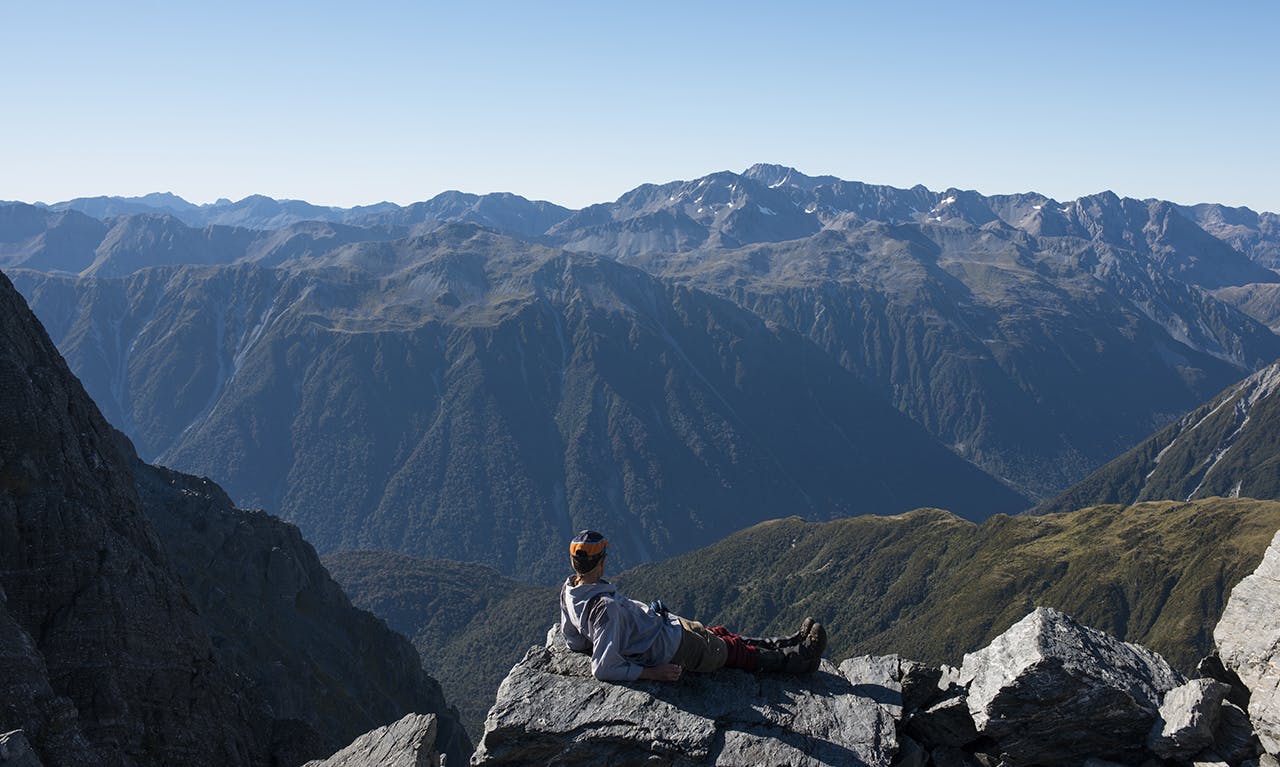
Resting on summit ridge of Tara Tama. Photo: Pat Barrett
The Taipo valley floor looks a long way down I think as we begin the descent over the summit to the east where we believe there is a faster route into Dunns Creek, a large tributary of the Taipo. First the going is easy; boulder fields, rocky gullies, and a small plateau. A broad scree face offers what appears to be the route off the south side of the mountain and though it goes well at the start, lower down it constricts into a deep, rock-walled canyon which steepens further into a deep z-shaped defile beyond which there is nothing but air.
Bluffed, we traverse out, enter another gully system, which we discover ends in a series of waterfalls which end in a giant cataract about 100m below.
Another traverse, up and over a sharp spur, more scrub bashing, a rocky rib, above us a bluffy face, and below – voila! It’s the way down, rough, but possible. Almost an hour later and we enter the upper reaches of Dunn Creek, tired, scratched, and relieved. The cool waters of the creek and its lightly marked route down to Dunns Creek Hut are a godsend and by 5pm we are unlatching the door, but we are not intending to stay. This is a rest stop only and we grudgingly leave the sunlit interior of the hut. There’s still a lot of riverbed travel between us and the road end, but with four usable hours of daylight left we feel compelled to attempt to get out.
Beyond the hut, there’s a good track to the lower creek bed and then relatively easy rock-hopping along this to gain the Taipo. The shadows are drawing their long arms over the valley as we ford the Taipo River several times to take advantage of the easier flats travel, but even with this advantage it is still near fully dark by the time we cut through the debris from the last big flood in the catchment, some two months earlier, to reach Dillon Hut. Its profile, set above the river on a large terrace, is familiar to me as I have visited before.
There are several groups inside, most bedded down for the night, so our late arrival creates some disturbance. We are not long in deciding to stay the night, the prospect of another couple of hours tramping and then a long drive home is not inviting. As it is we have been going for 14 hours since leaving Scottys Bivvy, and we’re done. It’s great just to take our packs off, prepare a tasty dinner and pull out our sleeping bags for a good night’s rest.
We’re on the go again, in the dark, next morning leaving the hut’s occupants to sleep on in peace while we make the final dash down the 4WD trails of the lower Taipo to reach the ute at sun-up. It’s been an exhausting tramp and climb, but I wouldn’t have thought so from the ear-to-ear grin Fr Antoine is wearing.
“They look like some good summits to try over there next time” he says, pointing towards the Taramakau Valley.
I shake and say: “I think it’s time to head home.”
Wild File
Access Turn-off SH73 at a signposted car park, 10km west of Jacksons Tavern. The road into the valley flats is rough and deeply rutted in places and unfit for cars
Grade Difficult
Time SH73 car park to Scottys Bivouac, 9hr; Bivouac to Tara Tama, 4-5hr; Tara Tama to Dunns Creek Hut, 4hr; Dunns Creek Hut to Dillon Hut, 3-4hr; Dillon Hut to SH73, 3hr
Accommodation Scottys Bivouac, 2 bunks; Dunns Creek Hut, 4 bunks; Dillon Hut, 10 bunks
Map BU20, BV20
