


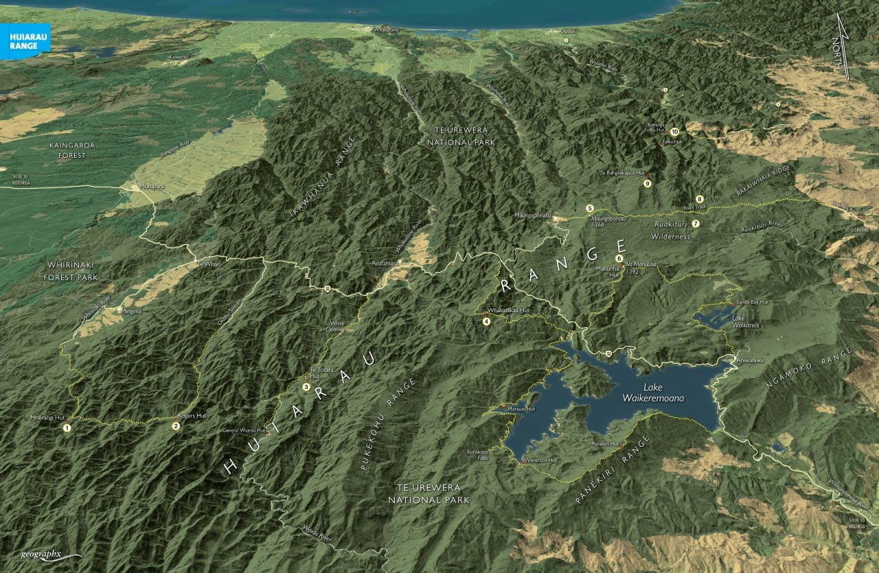

Dividing the Bay of Plenty from East Coast/Hawke’s Bay, the Huiarau Range forms a convoluted forested ridge through Te Urewera and adjacent Whirinaki Forest Park. Beginning somewhere in the complicated morass of bush ridges in the west of Whirinaki Forest Park, the range snakes its way north eastward, making numerous dog-legs, until petering out in the eastern Te Urewera somewhere in the vicinity of Rakaiwhaia Ridge. Following its entire length would be a difficult navigational challenge, and I doubt anyone has achieved it yet.
1. Moerangi Hut
A tidy nine-bunker of a design curious to the area, Moerangi Hut lies between the Okahu Valley and the main Whirinaki Valley, on the Moerangi Track, now accessible to mountain bikes.
2. Rogers Hut
Named after Roger Forrester, son of Rex Forrester, this historic hut was built in 1958 by a team of deer cullers. Deer culler Rex Forrester had learnt how to dress timber using a broad axe in the South Island and used these skills to make the cladding for this slab hut. DOC has since done some nice work on it, adding a veranda.
3. Te Totara Hut
Te Totara, as its name suggests, is built from durable totara cut from the bush in the White Valley on the western edge of Te Urewera National Park. Like Rogers Hut, this slab hut was hand adzed by Rex Forrester and his team during the mid-1950s. Good bushmanship, together with a bit of TLC since, ensured the hut has survived.
3. Whakatakaa Hut
Located on the Huiarau Range, near its junction with the Pukekohu Range, this six-bunk hut lies north-west of Lake Waikaremoana. Despite its proximity to the Waikaremoana Great Walk, Whakatakaa gets little use. It’s reached on a bush track that climbs steadily from the Whanganui arm of the lake.
5. Maungapohatu (1368m)
Sacred mountain of Tuhoe, this cliff-fringed massif forms the second highest point on the Huiarau Range.
6. Mt Manuoha (1392m) and hut
Highest point on the range, and also the highest part of Te Urewera National Park, this forested summit has a trig station and a small patch of subalpine vegetation, offering views of Lake Waikaremoana. The nearby hut sits tucked into the bush. The Manuoha Track, beginning from SH38, passes through some of the most exquisite stunted beech forest you’ll ever encounter. At a height of 1380m, the hut gets snow-covered most winters.
7. Ruakituri Wilderness
New Zealand’s newest wilderness, the 17,000ha Ruakituri was gazetted in 2007. Trampers have accessed the wilderness by dropping into the Ruakituri River from Manuoha Hut. Gorges, waterfalls, dense bush, challenging navigation and few tracks make it a wild tramping destination.
8. Rua’s Track
A bush route through the heart of Te Urewera, this historic track connects Maungapohatu and the Waimaha Road, on the eastern edge of the national park. It’s the only track through the Ruakituri Wilderness.
9. Te Rangaakapua Hut
Situated near the ridge crest, this small three-bunk hut is most often used by fly-in hunters. Situated at 1320m, the hut gets snow-covered most winters.
10. Koranga Forks Circuit, Waioeka Conservation Area
This three-day tramp follows rivers draining the northern aspects of the Huiarau Range. Beginning at Journey’s End Station, it follows the Kahunui and Koranga rivers, which together form the infant Waioeka River. Stunning bush scenery, two huts and exquisite rivers in an underrated tramping area.
