


A multi-day river journey that penetrates a wilderness of gorges, waterfalls, rapids and unbroken tracts of lowland forest – all of it steeped in culture and history. So special is the Whanganui River Journey it is rated alongside the country’s premier walks.
In 2017, the Whanganui became the first river in the world to be granted legal personhood. The legal entity, known as Te Awa Tupua, recognises the river as an
indivisible and living whole; incorporating the entire catchment from the mountains to the sea, along with the spiritual, intrinsic connection that exists with the iwi.
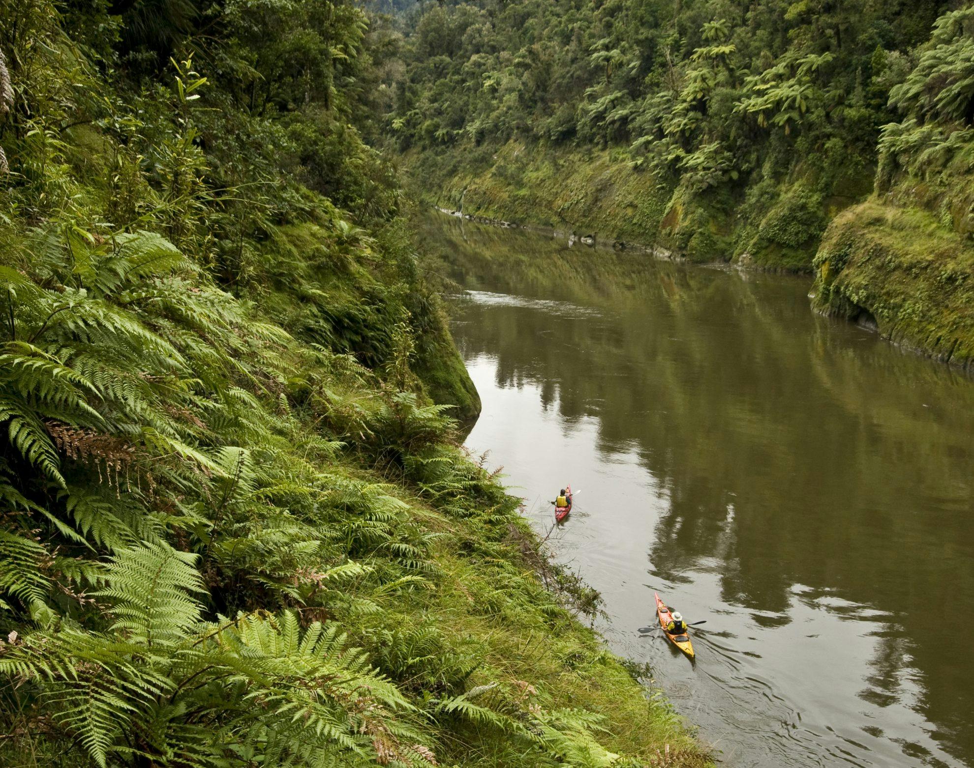
As a new organisation beds in this unique concept, the Whanganui flows on, carving ever-deepening gorges in the soft papa rock as it traverses a massive expanse of forested wilderness. Brown kiwi, whio, and long-tailed bats are among the rarer native species here. Much of the wilderness is encompassed in Whanganui National Park.
The Whanganui was once a major transport link, first for local iwi travelling by waka, then a brief but grand riverboat tourist era. Roads and rail have since diverted the ‘highway traffic’. Now, visitors paddle an essentially unchanged wilderness. The river is suitable for beginners; most of the 197 rapids are simple, bouncy fun, but others are more challenging, especially when the river rises, as it often does.
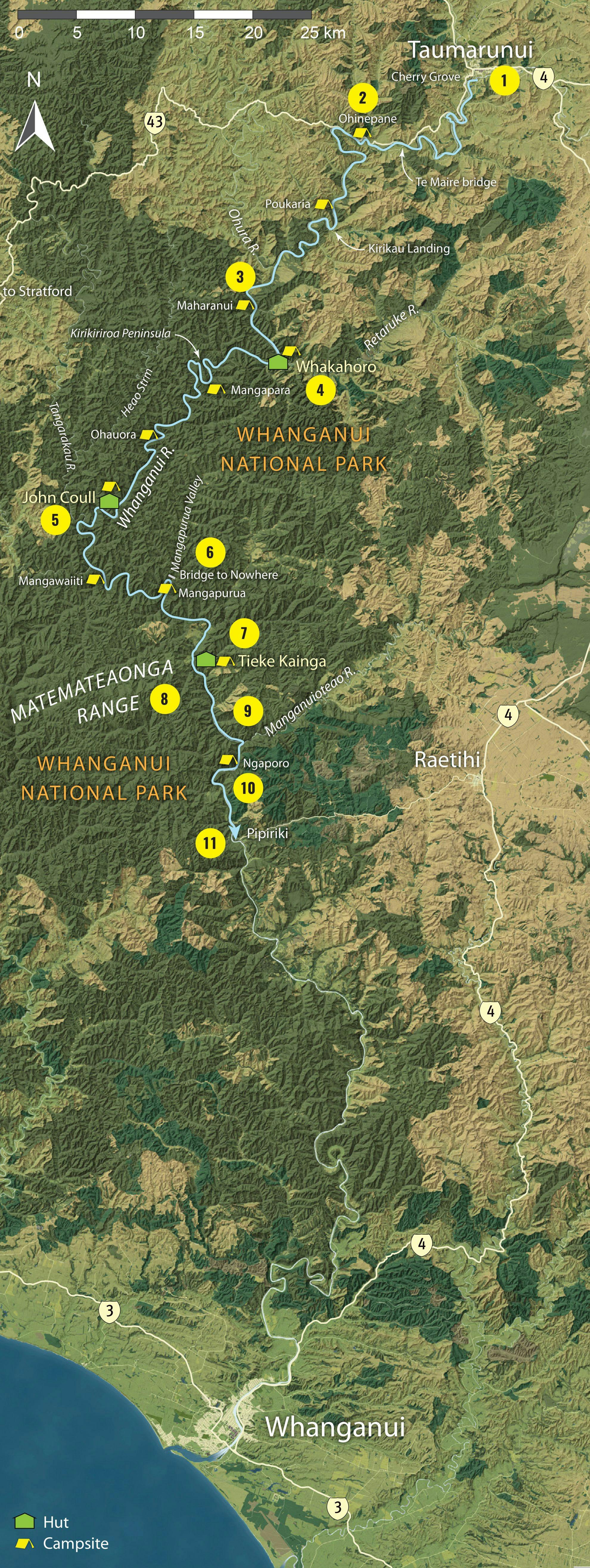
1. Taumarunui
A small farming town that also attracts outdoorsy folk coming to mountain bike nearby trails and canoe the Whanganui. Ngahuinga (Cherry Grove Domain), at the Whanganui/Ongarue confluence, is the traditional starting point; both for today’s river paddlers and for those in bygone days, travelling by waka or riverboat.
2. Ōhinepane
An alternative launch spot 22km downstream from Taumarunui, accessed from River Road (SH43).
3. Ohura Falls
It’s worth a short paddle into the Ohura River to see these falls. There’s nothing left to show that the Makere, a magnificent houseboat/hotel for riverboat travellers, was moored here for 23 years from 1904.
4. Whakahoro
Little remains of the riverboat landing, where tourists once mingled with farmers delivering wool bales and picking up supplies. There’s a great campsite on a big grassy area, also the Blue Duck Café nearby. Conservation project, Kia Whārite, focuses on protecting kiwi and whio habitats in the forests and streams around here. As the last road access before Pipiriki, 88km down river, Whakahoro is also a popular entry point for the Whanganui Journey.
5. John Coull Hut
This 24-bunk hut sits on a terrace, backed by tall rata, rimu and rewarewa trees in the river’s stunning middle reaches. Allow time to chill on the huge deck, especially at dusk when kiwi might call and long-tailed bats could flit by. There’s also a campsite here.
6. Bridge to Nowhere
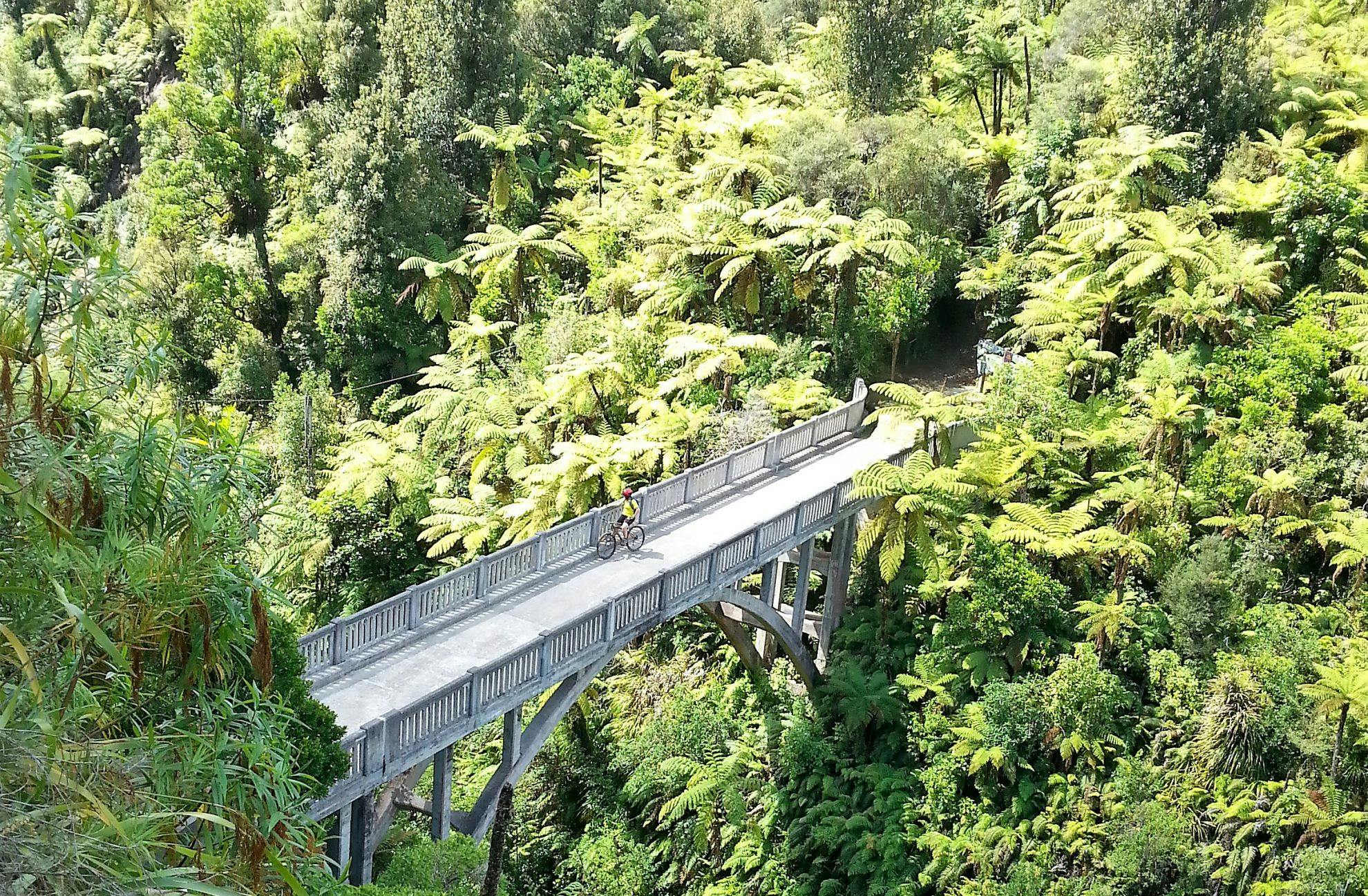
Haul up on the old Mangapurua riverboat landing and walk 40 minutes to the incongruous sight of a massive concrete bridge in, literally, the middle of nowhere. It was built for the long-abandoned Mangapurua farming settlement, which soldier/settlers tried but failed to establish in this isolated, steep, slip-prone country, following WW1. The old road is now a popular part of the Mountains to Sea Cycle Trail.
7. Tieke Kainga
A giant carved pou whenua here tells of the special marae/DOC partnership at the 20-bunk Tieke, where visitors are hosted by local hapu, descendants of Tamahaki.
A traditional welcome is sometimes accorded to arrivals, and a stay here can be an opportunity to
learn about the history of Tieke
and marae tikanga (protocol).
8. Puketotara Hut sidetrip
Take a break from paddling and hike onto the Matemateaonga Range for a night. A 1.5hr climb up the track will bring you to Puketotara Hut (eight bunks), nestled on a hilltop clearing surrounded by totara and other podocarps. Views extend across Whanganui National Park to Mt Ruapehu.
9. Manganuioteao River
One of the Whanganui’s most pristine tributaries, known for its whio population, it also has good trout fishing. The whio and the fish are generally further upstream, but for a gorgeous glimpse of what could be described as a ‘mini-Whang-anui’, paddle 100m or so into this steep, gorged river mouth.
10. Ngaporo Rapid
A notorious rapid, which in 1940 claimed the riverboat Ohura, losing its load of livestock and three crewmen.
11. Pipiriki
The river flows on a further 95km to the sea, but the official Great Walk ends here, where roads link with both Raetihi and Whanganui. A long-time Maori settlement and site of the former grand Pipiriki House hotel for riverboat travellers, Pipiriki today is a small, quiet village. A private campground with cabins occupies the former school.
When to walk
Driest period: January-April (88-106mm of rain)
Wettest period: June-October (more than 142mm of rain)
Warmest month: February (12.1-24.3°C)
Coldest month: July (2.4-12.5℃)
Quietest period: November and February to April all have nearly half the number of paddlers as January.
Best time: February
If you’re spending all day on the water, you might appreciate the warmer temperatures, and February is also significantly quieter than December and January.
Temperature and rainfall figures are monthly averages from the Taumaranui weather
station. Tramper numbers from DOC data from the 2016/17 season.
- Distance
- 145km
- Grade
- Easy / Moderate
- Accom.
- John Coull Hut (24 bunks), Tieke Kainga (20 bunks). Multiple campsites
- Access
- Taumarunui, Whakahoro (from Owhango or Raurimu), Pipiriki
GPX File
- Whanganui Journey (gpx, 169 KB)
GPX File
- Your device does not support GPX files. Please try a different device.
