


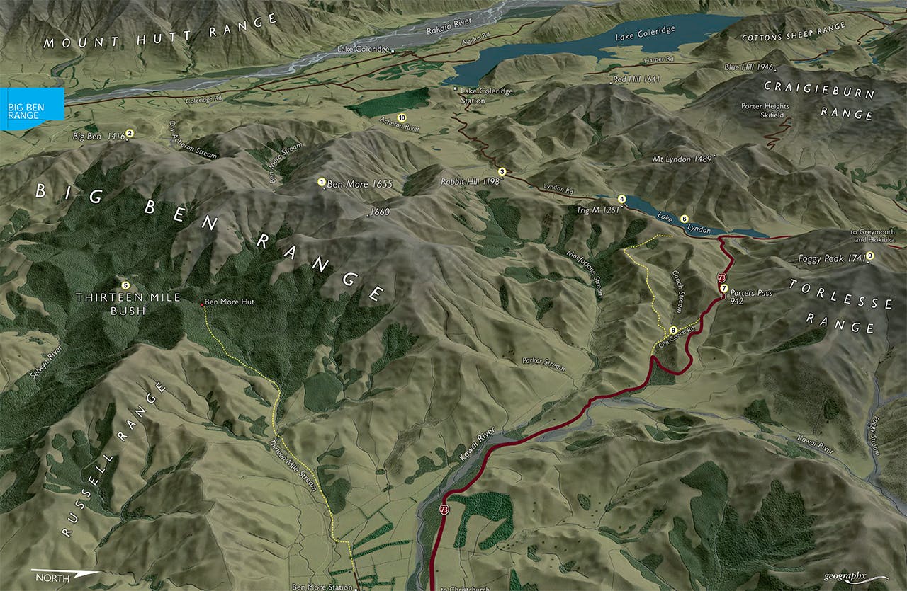

Torlesse-Korowai Tussockland Park
South of Porters Pass in Canterbury stands the open sprawling tops of the Big Ben Range, a series of foothill summits rising up from the Canterbury Plains and abutting the Torlesse and Craigieburn ranges. With the highest summit at just around 1600m and numerous easy angled approaches the range lends itself to moderate day trips, ski-touring in winter and hunting in the upper forested sections of the Selwyn River.
1. Ben More
The highest named summit is Ben More, 1655m, near the range’s northern end. It can be reached via any one of the long spurs spreading westwards from the summit and into the Lake Lyndon Basin. An unnamed peak just north of Ben More is measured at 1660m.
2. Big Ben
The namesake peak of the range, Big Ben, 1416m, lies near the southern end of the range, overlooking Rakaia Gorge. The two peaks can be easily linked to make a satisfying ridge-top traverse.
3. Rabbit Hill
The only other named summit on the range, though there are numerous spot heights, is Rabbit Hill, 1198m. It lies near the southern end of Lake Lyndon and offers a pleasant ridge walk with a great backdrop of scenery stretching all the way from the Rakaia Valley to the Torlesse Range.
4. Trig M
A marked and poled route commences below the western side of Porters Pass and climbs the tussock shoulders of the range to reach Trig M – a great viewpoint. It can also be linked with the Old Coach Road and Rabbit Hill.
5. 13 Mile Bush
This densely forested reserve covers the headwaters of 13 Mile Stream and the upper Selwyn and lies east of the Big Ben Range. It is largely untracked, except for the short track to Ben More Hut – an A-frame hunter’s hut at the head of 13 Mile Bush Stream – and is a popular forest for hunting.
6. Lake Lyndon
Scenic Lake Lyndon resides in a deep basin below the range to the west and is a popular lake for fishing and canoeing. It has a gravel road along one side allowing easy access. In winter the lake often freezes allowing ice-skaters to take to the ‘water’.
7. Porters Pass
The highway over Porters Pass grants ready access to the range and outlying waypoints and is also the starting point for several hikes onto the range.
8. Old Coach Road
In bygone days, Cobb & Co coaches plied the rugged mountain route between Christchurch and Greymouth, crossing over Porters Pass. A remnant of this trail still exists and is marked as such off the lower section (eastern) of the highway. It makes an excellent family outing.
9. Foggy Peak
Though on the adjacent Torlesse Range, Foggy Peak, 1741m, is a major landmark of the region and is also accessed from the summit of Porters Pass. The summit route is surprisingly steep in places and makes a great trip.
10. Acheron River
Opposite Rabbit Hill is the upper Acheron River offering several unmarked routes onto the unnamed sub-range here of which Red Hill, 1641m, and Mt Lyndon, 1489m, are the two major summits. They can be linked via the undulating ridge which has fantastic views into the upper Rakaia Valley.
