


A three-day trip in Mt Richmond Forest Park that should be on every tramper’s itinerary
Nelson’s Richmond Range offers spectacular tramping opportunities that include rolling tussock tops, rocky mountains and bush-clad valleys often reminiscent of North Island terrain. Indeed, the North Island edelweiss grows here, along with other rare alpine flora.
This 22km circuit of Mt Richmond is suitable for fit trampers with off-track experience. During winter, ice-axe and crampons should be carried. It’s important to note that there is no water on the alpine section of this route.
Two tidy NZFS-era huts help break the journey into three manageable days. Beginning at the western end means less height gain, especially if you use a 4WD.
Side-trips include ascents of Mt Fell and Johnston Peak. Both mountains were named after victims of the fated Kereru which crashed here during the Second World War. Wreckage from this aircraft can still be found scattered on the steep slopes of Johnston Peak.
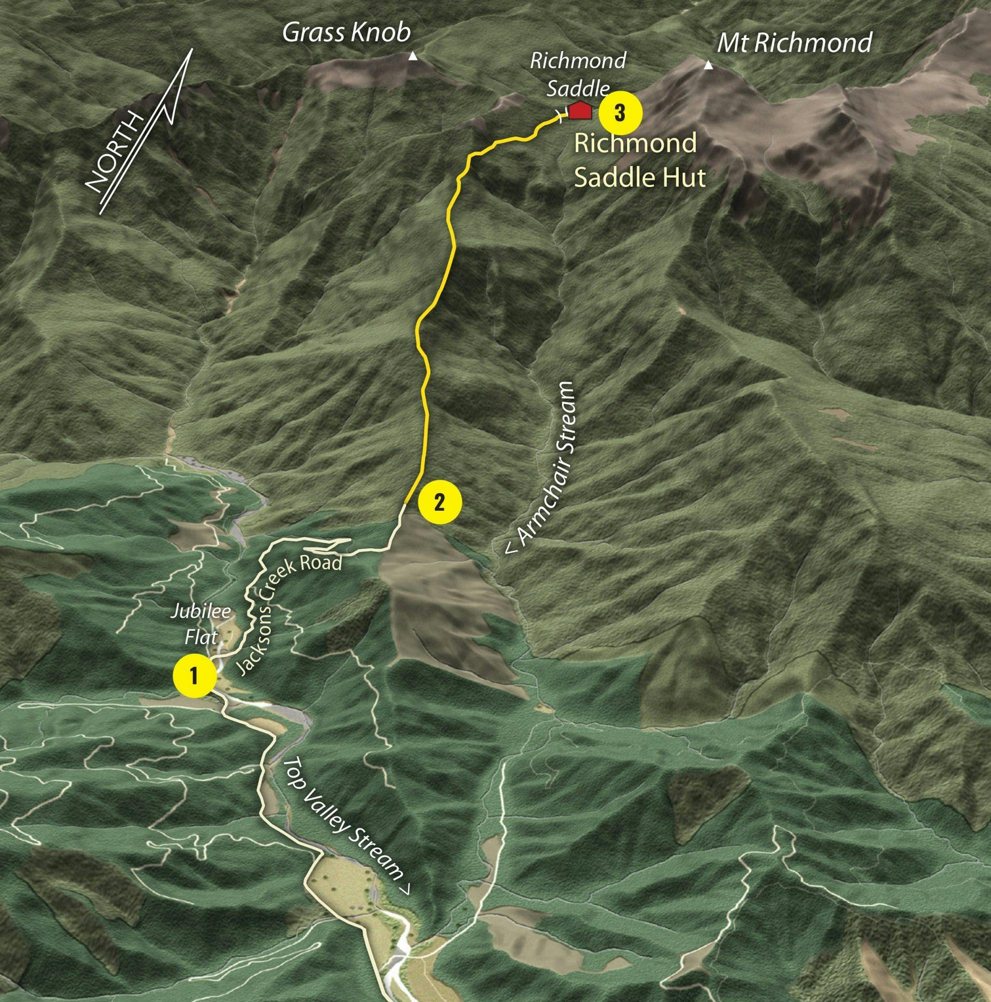
1. Jubilee Flat
Park here, or if the stream is low, ford Top Valley Stream and park on the top skid site on Jacksons Creek Road. This saves one hour of road-walking. Before leaving, check that logging operations have not restricted access up the valley.
2. Trailhead
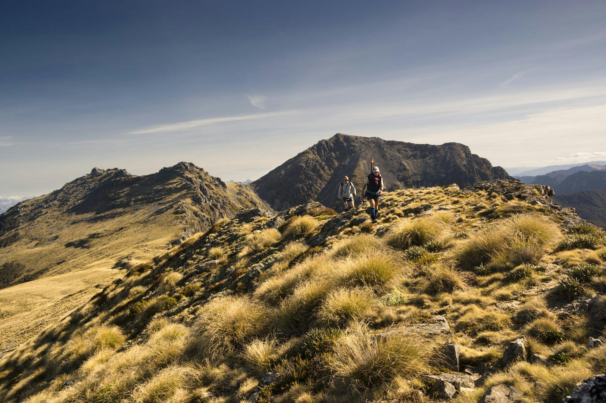
The marked ridge track is straightforward, climbing a steep spur, but gradually easing to reach the valley head. The trail then sidles above Armchair Stream to reach Richmond Saddle Hut in about three hours.
3. Richmond Saddle Hut
With eight bunks and a woodstove, this hut is a great launching pad for an assault on Mt Richmond. There are ample tent sites around the hut. The poled route east traverses unstable, rocky slopes which require good balance and confident footwork. Keep a lookout for the rare penwiper, vegetable sheep Raoulia eximia, the endemic daisy Celmisia macmahonii, and creamy white gentians.
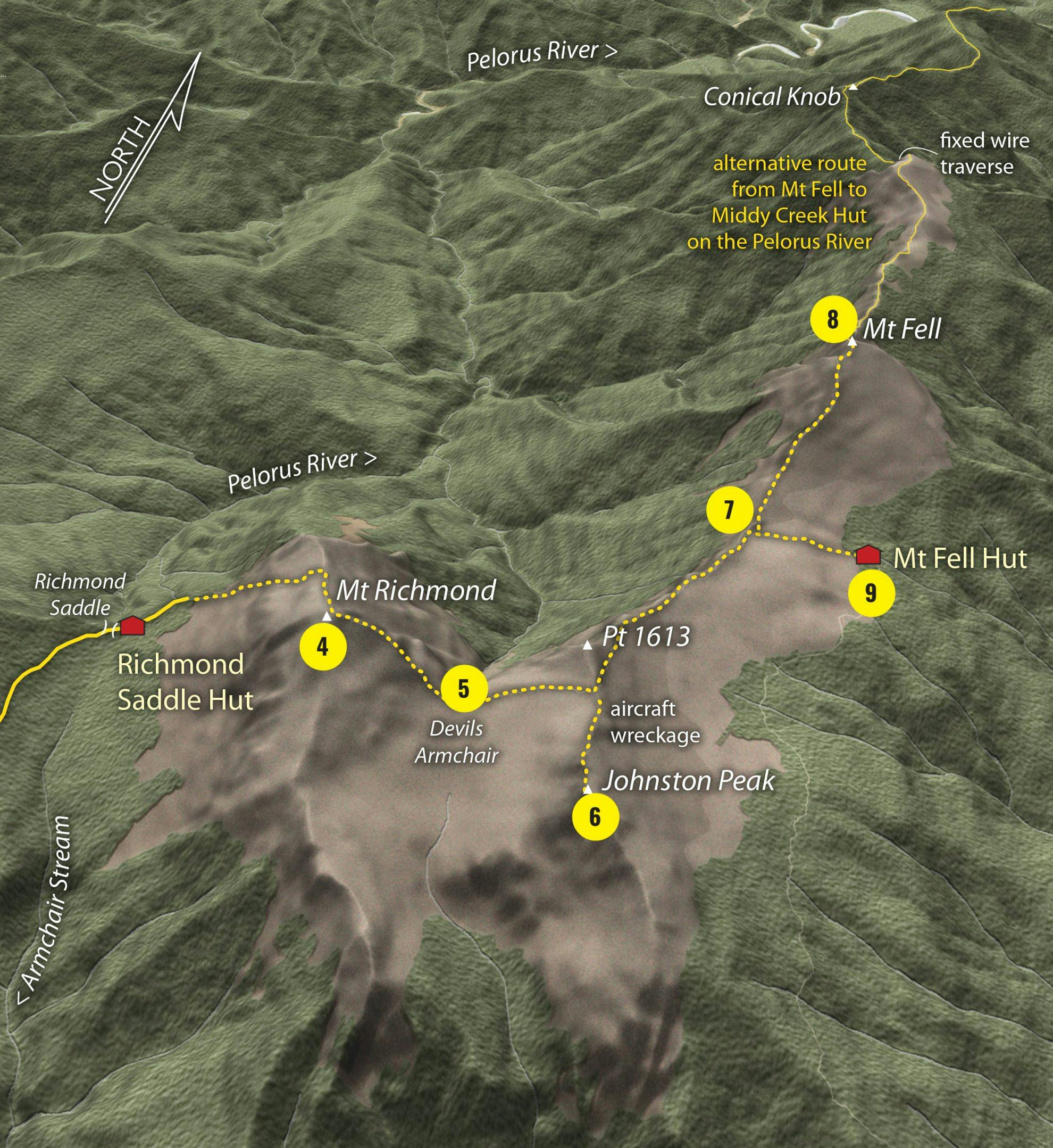
4. Mt Richmond
A couple of hours’ grunt up 40-degree slopes of shattered scree and teetering boulders will put you on the summit of Mt Richmond, the second highest in the park (1760m). This pyramidal peak is named after a prominent farming family in the Wairau. From the giant cairn, enjoy an extensive panorama that includes the Inland Kaikouras, Nelson Lakes, Kahurangi and, to the north, Mt Taranaki.
5. Devils Armchair
A short, sharp descent of the east ridge, over jumbled rocks and patches of scree, leads to a high tussock plateau. Weave through rocky ramparts to gain the saddle with Johnston Peak. Leave packs here if you wish to bag Johnston Peak. Allow an hour for the return journey.
6. Johnston Peak
A fun rock scramble, this rocky outlier (1647m) is named after pilot Keith Richard Johnston who died with four others in the Kereru crash on May 7, 1942. This was the first commercial airline disaster in NZ.
7. Mt Fell Hut junction
The route sidles around Pt1613 and continues along an escarpment to a sign-posted junction on a broad saddle. If inclined, drop packs here and head north to bag Mt Fell. Or, drop off the plateau into the bush to where Mt Fell Hut squats among stunted beech.
8. Mt Fell
An easy but adventurous jaunt from the track junction. Allow an hour to gain the summit (1602m). Listen out for the raucous cry of kea. Mt Fell is named after Nelson tramper Pamella Fell, who perished in the Kereru crash. A challenging poled route continues from Mt Fell along a gnarly traverse, down a gully via a series of chains, over Conical Knob, then down to Middy Creek Hut.
9. Mt Fell Hut
This tidy NZFS six-bunker, built in 1964, has recently been relocated and refurbished by the Nelson Tramping Club. It boasts epic views toward Mt Fishtail and is a convenient base from which to climb Mt Fell or search for the aeroplane wreckage on Mt Johnston. Camping is possible around the hut.
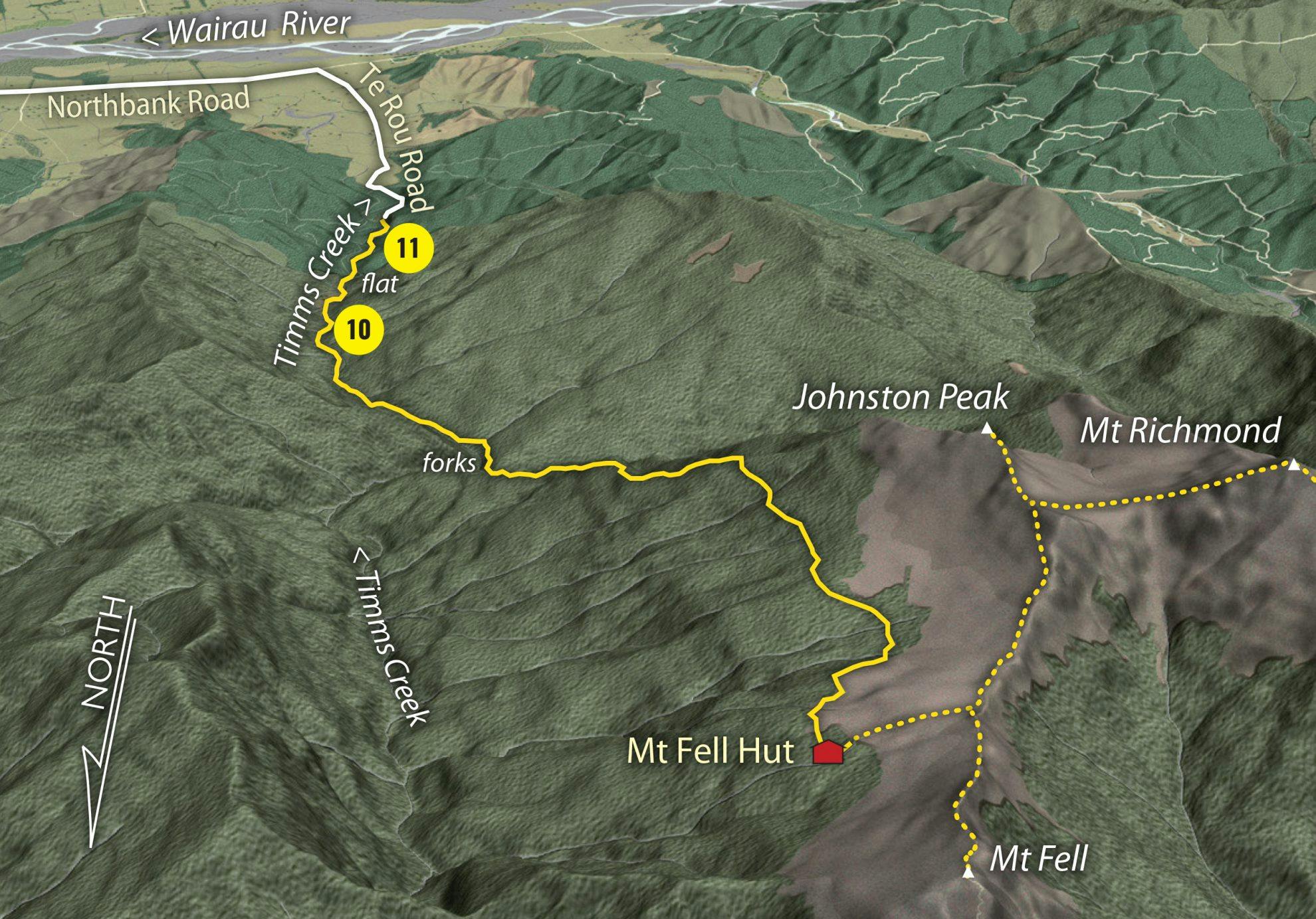
10. Timms Creek
The track sidles below the ramparts of Johnston Peak, below the treeline. After a sharp but short climb, a tedious 1000m descent ensues, down a forested spur to the valley floor. At the forks, in Timms Creek, the crossing can provide problems during wet weather. An easy track passes through attractive podocarp and mixed beech forest, along the true right bank to Timms Flat.
11. Timms Flat
A grassy picnic area with reasonable tent sites. Swimming is possible in the emerald green pools of Timms Creek. An old miner’s trail leads through exotic pines to the road end.
- Distance
- 22km
- Total Ascent
- 1360m
- Grade
- Moderate
- Time
- 2-3 days. Top Valley Rd to Richmond Saddle Hut, 3-4hr; Richmond Saddle Hut to Mt Fell Hut, 4-5hr; Mt Fell Hut to Timms Valley, 5-6hr
- Accom.
- Richmond Saddle Hut ($5, eight bunks); Mt fell Hut ($5, six bunks)
- Access
- From Northbank Rd, take Top Valley Rd for 6km
- Map
- BQ26
GPX File
- Mt Richmond-Mt Fell Circuit (gpx, 54 KB)
GPX File
- Your device does not support GPX files. Please try a different device.
