


Everything you need to know about walking the Tararua's classic Southern Crossing
There’s no doubt that of all the Tararua tramps, the Southern Crossing is the classic – purpose-built tramping tracks don’t come much older.
The crossing dates back to the early 20th century when a group calling themselves the Mt Hector Track Committee cut a route and built three huts, including the original Alpha (1915) – the first alpine shelter in the range.
On my first attempt at a full crossing, beginning up the Marchant Ridge, poor weather ended the trip prematurely at Alpha Hut. And even when I finally completed the crossing, visibility was little and the wind toyed with us like we were drunken puppets. Such is the pernicious nature of a range exposed to the weather from every direction.
I learned to choose my trip to coincide with good forecasts, and have since enjoyed the best the Southern Crossing has to offer: watching the evening light reveal ridge after tawny ridge, the sun sinking beyond Kapiti Island – lying like an upturned boat in the Tasman Sea; Kime Hut gleaming in the frost of a clearing southerly; the curiously feathery form of the Tararua speargrass, the showy flowers of North Island edelweiss, the Mt Hector cross festooned in sastrugi; and mist wafting through the moss-encrusted silver beech trees of the Marchant.
It’s ironic that this route is not actually a crossing and does in fact start and finish on the western side of the Tararua Range. The original Southern Crossing used to finish (or begin) at Walls Whare, near Greytown, but most parties now opt to end at Kaitoke, near Upper Hutt, where there are better transport links.
My preference is to begin at Otaki Forks, which has the option of retreating to Field Hut if the weather worsens on the tops. It’s shorter and easier than a long withdrawal down the Marchant Ridge. While camping is limited, there are places, such as near Field Peak, where small tarns exist.
In winter, the Southern Crossing offers excellent alpine tramping, with snowshoes a good option in the right conditions. However, the route has claimed many lives, mostly from hypothermia, and the crossing should not be underestimated. Pick your weather, plan carefully, and be prepared to back off – that’s the respect this range demands.
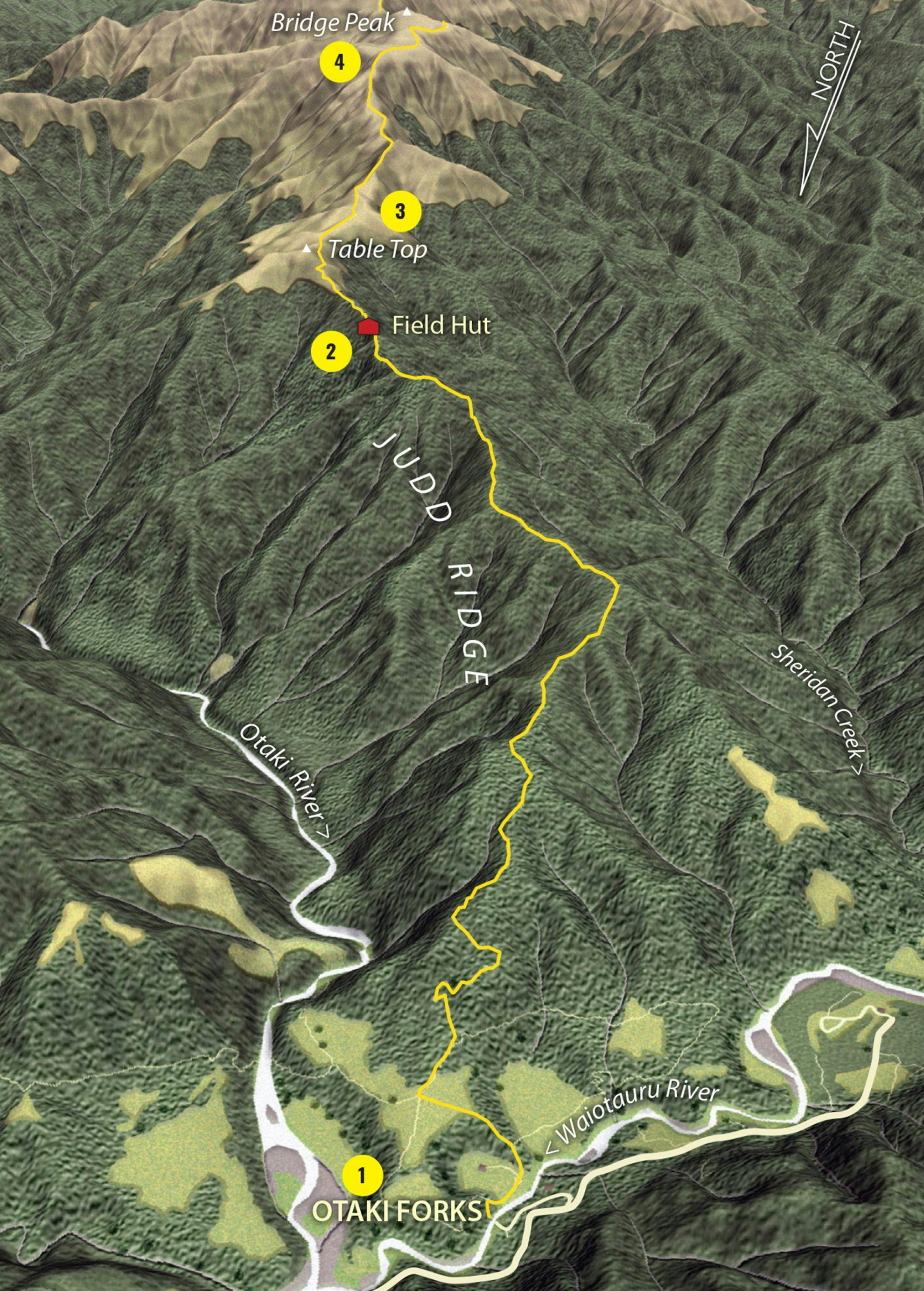
1 Otaki Forks
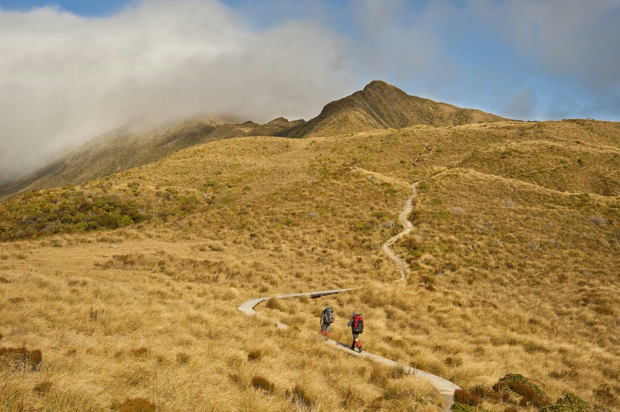
Once the site of a small milling settlement, Otaki Forks is where several rivers meet, and the Southern Crossing begins. From a car park and picnic area, cross the footbridge over Waiotauru River and begin the climb towards Field Hut. The track initially passes through regenerating scrub, but soon enters more mature forest of kamahi, hinau and totara.
2 Field Hut
It says much about the skills of bushman Joe Gibbs, and the subsequent efforts of the Tararua Tramping Club, that this hut still exists – largely in its original form. Built by Gibbs in 1924, it was constructed from timber cut on site. Situated just below the bushline, it’s nicely sheltered and rightly celebrated as the oldest purpose-built tramping hut in the country. It was built after club member Harold Freeman died of hypothermia while attempting the crossing in 1922.
3 Table Top
Beyond Field, the track climbs to merge into the tussocklands and undulating terrain of Table Top. A boardwalk crosses boggy terrain and views of the range stretch north and south.
4 Bridge Peak
A steady upward climb on a well-worn route, marked by occasional poles, reaches a track junction at Bridge Peak (where the route along the Main Range branches off). This knoll is named after Bill Bridge, a second generation TTC member who made a huge contribution to developing Search and Rescue.
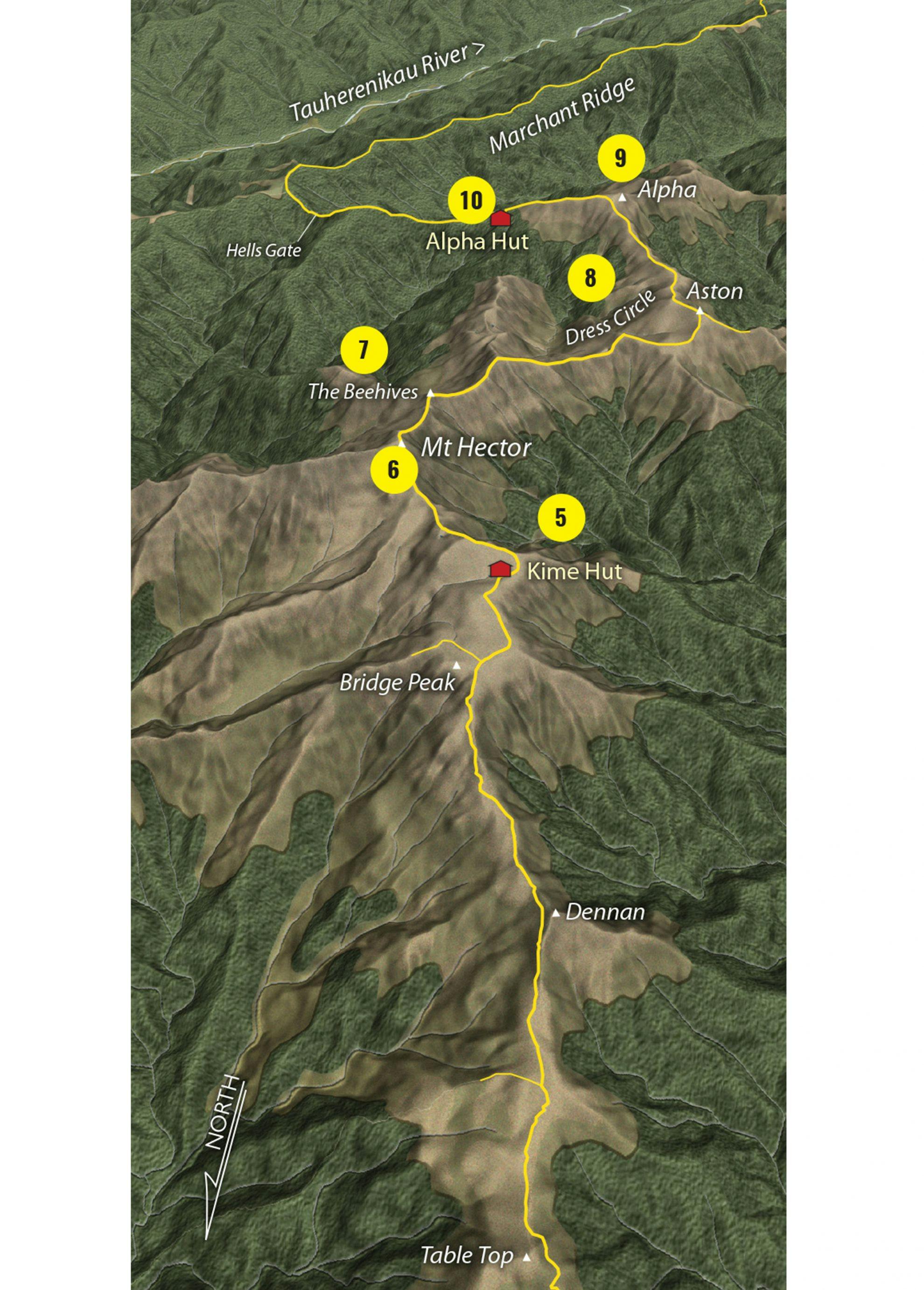
5 Kime Hut
Unlike Field, Kime Hut has been through three different incarnations. The original hut was built by the TTC in 1930 after the hypothermia-related death of Esmond Kime on the exposed tops. It was replaced in 1978, but though a pleasing shape, the high-ridged hut was never warm. DOC replaced it with Kime III in 2014.
6 Mt Hector
Beyond Kime, the track climbs to its highest point, Mt Hector (1529m), where a wooden cross commemorates those trampers who lost their lives in war. Naturally, it offers fine views, even as far as Mt Taranaki.
7 The Beehives
These two mounds, known appropriately as The Beehives, form the narrowest section of the entire route, one that can be dangerous in high winds or winter conditions.
8 Dress Circle
After The Beehives, the terrain becomes flat, almost moor-like, before arcing around a sickle of tops known as the Dress Circle to Aston. Poles at key places help navigation where the topography loses definition.
9 Alpha
On a good day, Alpha affords perhaps the best vantage point of the crossing, with views over the sweep of the Dress Circle and the extensive forests of the neighbouring Tauherenikau and Hutt catchments – not to mention the distant Kaikoura mountains and Marlborough Sounds.
10 Alpha Hut
A descent off Alpha leads to the bushline, and shortly beyond, Alpha Hut. The TTC took over the original hut, but, when authorities made a draconian decision to exclude trampers from the Hutt catchment in the 1950s, had to rebuild it at a new location. Alpha II burned down in the early 1980s, and the Forest Service replaced it with the existing hut in 1983.
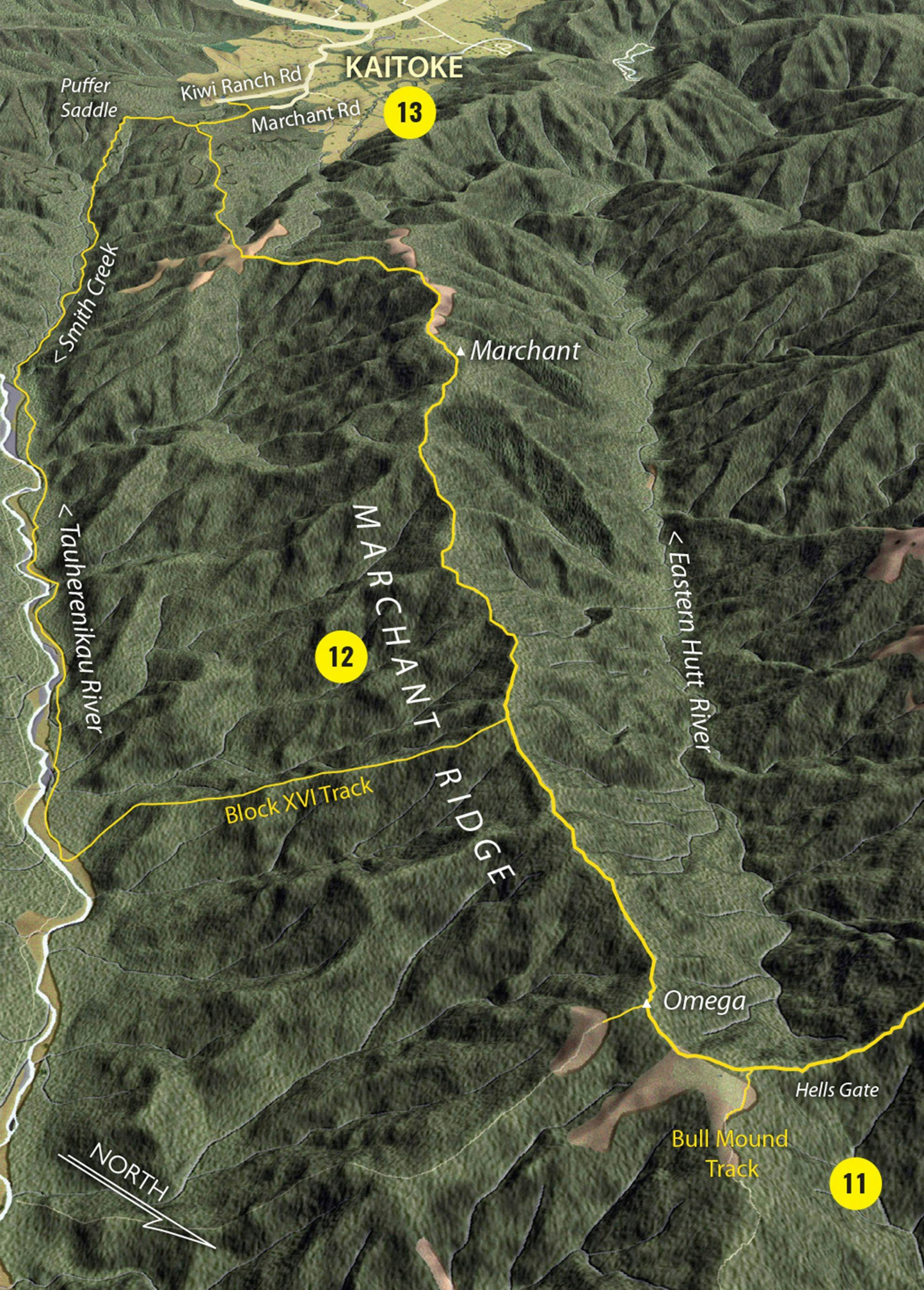
11 Hells Gate
Beyond Alpha, the track dips into a saddle with the somewhat exaggerated name of Hells Gate before reaching a track junction to Bull Mound. It continues along Marchant Ridge.
12 Marchant Ridge
The Marchant has a deserved reputation as a long slog, with rooty, muddy, undulating travel through stunted beech forest. Part of the ridge was burned in a great fire in 1938. My personal preference (even though it takes longer) is to drop down the Block IV track to the Tauharenikau Valley and Smith Creek tracks.
13 Kaitoke
The tramp concludes at a large gravel car park at the end of Marchant Rd, off SH2 at Kaitoke. Cars are frequently vandalised here, so you’re better to park at the car park on Kiwi Ranch Road.
- Distance
- 34km
- Total Ascent
- 2912m
- Grade
- Moderate / Difficult
- Time
- 3-4 days. Otaki Forks to Field Hut, 2.5-3hr; To Kime Hut, 2.5-3hr; To Alpha Hut, 4-5hr; To Kaitoke via Marchant Ridge, 6-8hr
- Accom.
- Field Hut ($5, 20 bunks); Kime Hut ($5, 20 bunks); Alpha Hut ($5, 20 bunks)
- Access
- From Otaki Forks, Otaki Gorge Road
- Map
- BP33
GPX File
- Southern Crossing.Tararua FP (gpx, 102 KB)
GPX File
- Your device does not support GPX files. Please try a different device.
