


Three beacons worth bagging
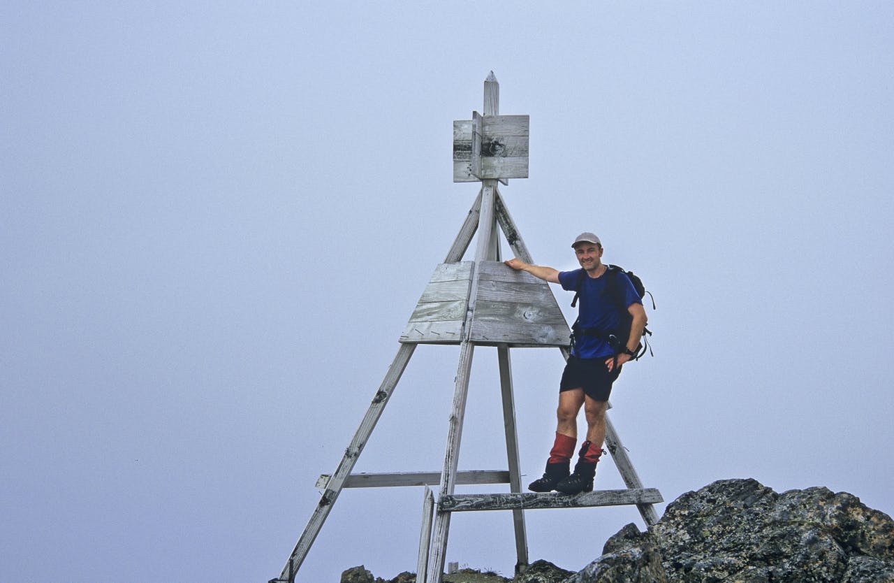
Many of us go into the mountains to avoid manmade structures, although of course we’re often grateful for a hut, bridge or track marker. To that list, I’d also add trig station beacons. More than once I’ve been thankful to see the wooden tripod-shape of a beacon materialise out of the mist.
Trig is short for trigonometrical station. Surveyors established these stations in order to fix positions by means of triangulation, a crucial step in making sense of the landscape for mapping. Pioneer surveyors usually sought out mountaintops, as these provided the best vantage points for undertaking measurements.
Strictly speaking, a trig station is simply a fixed point, marked by a steel pin set in the ground – although most trampers use the name to refer to the ‘beacon’ built above it. These wooden or metal structures are usually painted in black and white for maximum visibility. Land Information New Zealand (LINZ) has responsibility for trig stations.
Topographical maps depict beaconed trig stations as a solid black triangle, with non-beaconed ones shown as an open triangle. It’s the beacon, of course, that’s useful as a navigational aid to trampers, though be warned that metal beacons may interfere with your compass. I once got wildly varying bearings when navigating off Mt Holdsworth (Tararuas) in misty conditions and took a while to figure out why.
Because of their usefulness, and as symbols of ‘reaching the top’, many trampers have developed a fondness for these simple structures. Some trampers have even become, to coin a phrase, ‘beacon baggers’. LINZ surveyor-general Don Grant has climbed to New Zealand’s 11 highest trig stations, although not all still have beacons, becoming the first surveyor-general to climb to the highest trig station on Mt Tapuae-o-Uenuku (2884m). Although only eighth on the highest list at 2515m, Mt Brewster is the hardest to climb. When three surveyors first established a trig station on the mountain in 1979, an epic almost ensued. After completing their work, a blizzard blew in, foiling the intended helicopter pick-up. Fortunately, one of the surveyors had anticipated this and carefully belayed the other two off the mountain until they got below the cloud.
Others in the top 11 include: Manakau (2608m) and the 2590m Te Ao Whekere; Mt Gladstone (2370m), Mt Cold (2348m) and the 2338m Mt Travers. Although three peaks on Mt Ruapehu and Mt Taranaki’s summit have trig stations, none have a beacon, making Mt Tongariro (1961m) the highest beaconed trig station in the North Island.
These days, satellite technology enables pinpoint accuracy for surveying. More trampers are also using GPS devices. Subsequently, the need for maintaining beacons at trig stations has largely disappeared and over the last 20 years I’ve seen some backcountry ones fall into disrepair.
LINZ has a maintenance program for key beacons, with highest priority going to those that are still important for surveying.
Sadly, LINZ staff recently replaced some prominent beacons in Tararua Forest Park (on Girdlestone, Mt Dundas and Taungata) with marker posts. Restoring a sample of historic beacons would help preserve an important part of our surveying heritage. I’d be sorry to see them disappear from our backcountry entirely.
– Shaun Barnett
Pureoroa, Pureora Forest Park, Wairarapa
The highest peak in Pureora Forest Park, Pureora (1165m) sports a prominent wooden beacon and commands views over Lake Taupo, the King Country and the mountains of Tongariro National Park. Reaching the summit takes about an hour on a track that climbs steadily through a sequence of forest from large podocarp trees to the sub-alpine shrubs surrounding the top.
Mt Technical, Lewis Pass National Reserve, Canterbury
At 1870m, this significant summit lies above the Lewis Pass highway and is best reached by a delightful ramble over the tarn-studded Lewis Pass tops. There’s a choice of routes to the summit of Mt Technical, with the northern, western and eastern ridges all requiring some rock scrambling ability. However, a route up a scree-slope on the peak’s south-western side gives easier access without the need for any scrambling.
Mt Tapuae-o-Uenuku, Inland Kaikoura Range, Marlborough
New Zealand’s highest mountain outside the Main Divide, Mt Tapuae-o-Uenuku dominates the Inland Kaikoura Range and lures trampers and mountaineers from all over the country. The standard route goes up the Hodder River to Hodder Huts. From there, a route up Staircase Stream leads into a large basin, from where the summit can be climbed. While not technical during summer conditions, the ascent requires fitness and good weather.
