


- Area
- Tongariro National Park
- Time
- Waterfall Express chairlift to summit, 3.5-4.5hr; Summit to Tama lakes camp, 6-9hr (depending on how Waihohonu Ridge is accessed), Tama lakes campsite to Whakapapa village, 2.5-4hr.
- Grade
- Moderate
- Access
- From the top of Bruce Road take the chairlifts as high as you can. In summer, it is possible to walk from the walk end
- Map
- BJ34, BH34
To mark Wilderness magazine’s 30th anniversary, current and past editors and contributors scoured the archives for the 30 best trips we’ve published over the decades. This story, original published in October 2013, was included. You can find all 30 of the greatest Wilderness trips in the October 2021 issue.
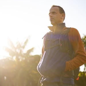
Alistair Hall fulfils a New Year’s resolution and goes off track in more ways than one
The plan was simple: three peaks, three days.
We’d hire some snowshoes, climb Mt Ruapehu, descend via the mountain’s northern Waihohonu Ridge, tramp over and climb Ngauruhoe and then Tongariro. No huts, no tracks. Piece of cake.
On paper, with a total distance of 40km, it looked eminently doable. And it would have been if ‘on paper’ translated to ‘on the mountain’.
It took about seven months to sell Scottie on the trip, a New Year’s resolution of mine to go off track in winter in Tongariro National Park. “This will be something you talk about for the rest of your life,” I crowed one Saturday morning as we ate breakfast in one of Scott’s usual haunts, a Ponsonby café. Scott is a marathon runner, not a tramper so he was understandably unsure. But he was also on his second cup of coffee and I could see the caffeine had made him excitable. He looked antsy and his leg was thumping up and down beneath the table. I went in for the kill.
“If we get good weather, it’ll be amazing – easily the best time of your life,” I said, then promised: “If the weather packs it in, we will too.”
That was the clincher. “OK, let’s do it,” he said.
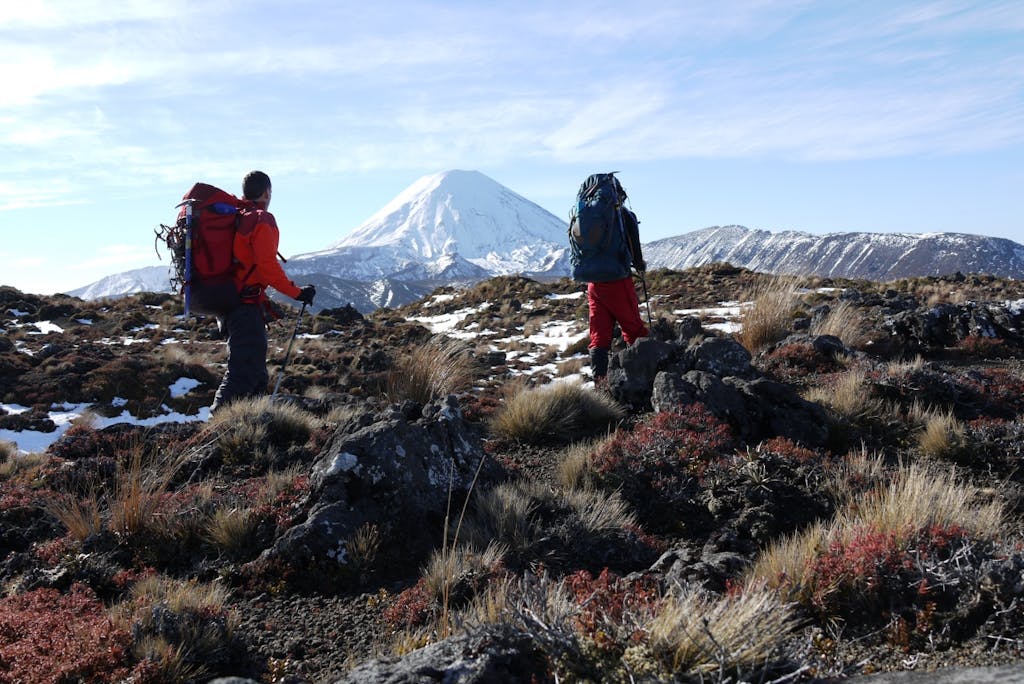
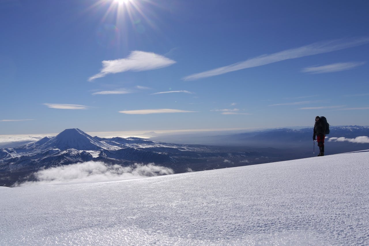
Ngauruhoe lured us on from the bottom of Waihohonu Ridge.
Fast forward two weeks to the hire shop in Whakapapa Village and we’re looking at two pairs of very cheap plastic snowshoes, a far cry from the MSR Denali Evo Ascents I had used when climbing Mt Tongariro a couple of winters back. The puny spikes on these would struggle to pierce a balloon, let alone the ice-encrusted slopes higher up the mountain.
I looked over at the range of crampons and ice axes on offer. Scott was fidgeting, less from coffee this time and more from very real nerves as his mind ticked through worst-case scenarios.
I had to get him believing in me again, so confidently requested the shop manger give us the blue Simond crampons, not the abused-looking unbranded ones in her hands. She raised an eyebrow in mock surprise. “O-Kay,” she said, drawing out the word to show she didn’t think I quite knew what I was talking about. I soon found out why. Though newer and shinier, the Simond crampons were not flexible, whereas our boots very definitely were. Scott looked like he was about to bail.
Kitted out with crampons and an ice axe each, we rode the Waterfall Express chairlift high up the mountain feeling like frauds the whole way. Not only had I flippantly missed the difference between flexible and rigid crampons, but we were taking the easy route to the summit. On the long ride up, I wondered if using the chairlift made me a hypocrite for my opposition to the proposed monorail to Milford.
Waihohonu Ridge is easy to walk down, though the soft volcanic soil would make it difficult to hike up.
We hiked alongside the Knoll Ridge T-Bar, keeping well out of the way of speeding skiers who seemed not to notice us until the last second. Under my heavy pack, it took me awhile to get into the swing of things and Scott soon opened up some distance. He may not be used to carrying packs, but he was a hell of lot fitter than me. He would pause every now and then to watch my slow progress and allow me to briefly catch up.
We left the skiers behind at the top of Knoll Ridge and aimed for the cleft in the summit between Dome and Glacier Knob. The slope steepened in earnest here, and while I did my best to get Scott to zigzag our way up, he went for the more direct route. He shouted something back about his reasons for the directissima approach, but his words were lost on the wind, which was gusting furiously and sending balls of ice and snow pelting into us. I zigged and zagged as much as I could, looking for any opportunity to catch my breath.
With an unnaturally fast pace set, we found ourselves on the summit at 3.45pm – less than four hours after starting out from the chairlift.
It was still early so we debated whether to continue on down Waihohonu Ridge to get a head start on the following day’s hike. I was secretly hoping we would, otherwise reaching Ngauruhoe on day two would be difficult.
But this was Scott’s first time on the summit and I had sold the trip as being a one in a lifetime opportunity. Bedding down in the highest campsite in the North Island fitted the bill perfectly.
We struggled to pitch the tent as strong gusts, which were forecast to hit 70km/h, blew across the plateau and threatened to turn it into a fly-away kite. At one stage I held on for dear life as it flapped and tugged in the wind while Scott frantically raced around searching for the pegs, which had been torn from the snow and flung in all directions across the ice. We finally managed to pitch it by pegging down two of the corners and then holding the tent down until the pegs froze in place. We tied the guy lines to our ice axes and sunk them deep into the snow.
Satisfied our shelter wasn’t going anywhere, we decided to explore the icy expanse of the plateau. Scott climbed up the crater to view Crater Lake while I waited below and watched as the sun made its slow and inexorable descent below the horizon.
The wind played havoc with our cooker. I had forgotten my stove’s windshield and heat reflector so it took an age to melt snow with the flame dancing across the bottom of the pot as the wind blew it this way and that. Just as the water began to bubble some 45-minutes later, the flame spluttered out of gas. We’d have to conserve our remaining fuel from here on.
We tried to get away early the next morning, but it had gone 8.30 by the time we had our packs on. Or rather, I had my pack on. Scott’s dilly-dallying is the stuff of legend, but I never thought he would bring this much-vaunted skill to the top of a mountain where standing around in sub zero temperatures made for an extremely uncomfortable experience.
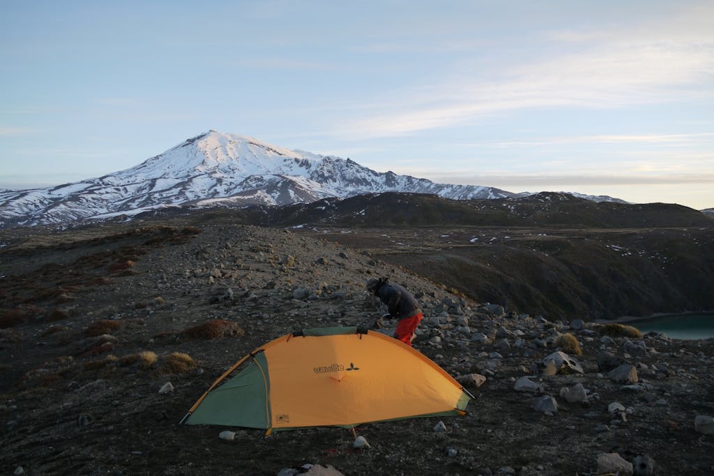
The campsite overlooking Lower Tama Lake.
He put his pack on, only to realise he hadn’t tucked in his jumper. Off came the pack, in went his jumper. Then he needed a toilet break. Where were his gloves? Exasperated, I left him to it and made my way to Tukino Peak from where I thought we could sidle around Ruapehu’s northern flank to Waihohonu Ridge. But stepping off the summit onto the slope seemed outrageously risky. It was much steeper than I expected and the run-out looked terrible. Standing on the edge, looking at the slope felt like the moment when the rollercoaster crests the summit and gravity takes over. My stomach lurched at the thought and butterflies began to flutter. My instinct was to retreat the way we had come and the rational part of my brain recognised that without ropes or anchors we would be taking a huge risk. But an irrational, impatient side reasoned retreat would almost certainly destroy any chance we had of getting to Ngauruhoe that afternoon.
I looked over to Scott. He was still struggling with his gear near where we had camped. Really? I walked over to explain we would need to retrace our steps and attempt the sidle from lower down the mountain. Topping out on Ngauruhoe and Tongariro was looking like a very distant goal, indeed.
Scott’s pace from the day before all but vanished as he granny-stepped his way down the slope. It was my turn to wait for him and when he finally caught up, he was looking decidedly out of his comfort zone. I pointed 200m across the slope to a flattish area from where we could scope out our route to Pinnacle Ridge.
“But we don’t know what’s over there,” he said.
“What do you mean,” I asked. “It’s the way we need to go.”
“It could be too steep. We don’t know what it’s like.”
“What’s the alternative – go home because we don’t know what’s over there? Let’s find out and then make a call on it.”
From the vantage, we could see we would need to drop into a small valley before climbing onto Pinnacle Ridge. We descended to a point just above the Valley T-Bar, gutted to see signs of civilisation so soon, and began climbing the easy snow slopes to gain Pinnacle Ridge. “But we don’t know what’s up there,” Scott said.
“Let’s find out,” I replied, and quickly moved on.
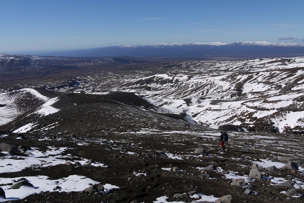
From Pinnacle Ridge, the entire northern expanse of Tongariro National Park lay before us. The massive bulk of Ngauruhoe came into view and Tongariro’s snowy summit poked its head above Pukekaikiore. As I expected, the way ahead was clear. Pinnacle Ridge’s jagged knife-edge dropped away to our left. To our right a steep slope carried on up to Tukino peak, requiring more sidling to reach Waihohonu. The most attractive option was straight ahead: a snow bowl offered the chance to slide down the mountain to a point where accessing our target ridge would be a simple amble.
Scott volunteered to slide first, even though he had never done it before. As he picked up speed, the head of his ice axe began bouncing out of the snow so I shouted belated instructions on how he could stop himself: “Lift the handle to dig the pick into the snow!”
“What?!” came a panicked cry.
In this way we quickly lost 300m of altitude, though it wasn’t until about the 1980m contour that we finally found an easy route onto Waihohonu Ridge.
The ridge was once used by climbers staying at Waihohonu Hut to climb Ruapehu, presumably before Bruce Road sped access. The soft volcanic soil was a pleasure to walk down, each footfall cushioned with a comfy landing that felt like we were walking on clouds after two days in crampons. Going uphill would be a different kettle of fish entirely; every step an energy-sapping partial slide backwards.
With Ngauruhoe firmly in our sights, we began to make some decent progress as we fairly raced down the snaking spine of the ridge. But we were also getting desperately thirsty. Our water had frozen during the night and still hadn’t defrosted despite strapping our reservoirs to the outside of our packs where the blazing sun could work its magic. We were reluctant to melt more snow for fear of running out of fuel and now I had a thumping headache, dry lips and a tongue that refused to cooperate when I tried to speak.
We dropped off Saddle Cone and mistakenly headed east instead of continuing north. We suddenly found ourselves in a small valley that would take us on a long detour if we didn’t climb out of it. But then it occurred to me that where there’s a valley, there’s often a stream. Sure enough, a short distance below was a creek. We raced over and fell to our knees, slurping from the partially frozen water. We felt like two lost souls in the desert stumbling upon a life-saving oasis. We slaked our thirst, tipped out our frozen water and loaded up with five fresh litres between us.
We continued on down the ridge, which was becoming more difficult thanks to the alpine tussocks and shrubs growing at the lower altitude. The ground was uneven and though the snow cover was patchy, we would often sink up to our knees and go sprawling. After the long descent, Scott was back in his element and did most of the pot-holing, while I led from behind, calling out instructions on which way to go.
The ridge ended abruptly with a steep descent to the Whakapapa Waihohonu Track. We barely paused as we crossed the track and continued on our way to Tama Lakes. Our plan had been to camp at Upper Tama, between points 1584 and 1562 directly beneath Ngauruhoe. We still had four kilometres to go.
Travel through the permafrost-like tundra was slow going as we skirted numerous semi-frozen mini-tarns. Having made little progress and with 90-minutes of daylight left, we concocted another Plan B: a campsite overlooking Lower Tama. The decision was a bitter pill to swallow: we had admitted defeat and there would be no climbing Ngauruhoe or Tongariro now. But the decision was made easier by the fact I was utterly shagged and needed rest.
I flirted with the idea of salvaging the expedition by skipping Ngauruhoe and just climbing easier Tongariro, but even that seemed optimistic. Best case scenario would see us walking 26km on the final day and we needed to be back at our cars by midday.
We climbed onto the ridge between the two Tama lakes and found a campsite overlooking Lower Tama we guestimated to be DOC’s mandatory 500m from the track.
We immediately got our cooker going to heat up some water for dinner and that’s when I discovered why I was feeling so much more tired than Scott. When we had filled up with water at the creek, my larger reservoir held three-litres to his two and we had decided to save enough water for the meals and as much for the next day as possible. So while I had conserved all but 500ml, Scott and drunk his entire two-litres, handily reducing his pack weight by two kilos. I could only assume Scott’s life as a solitary marathon runner was poor preparation for more social, team activities.
To compound matters, our stove performed even worse here, producing less heat than it had the night before at a higher altitude and in colder weather. When an hour later the sun had set and the water still hadn’t boiled, we gave up hope of a hot meal and opted for lukewarm-fast-becoming-cold. Despite the gourmet promises on the packaging, it was quite possible the worst meal I’ve ever had in the hills.
At least the setting was quite extraordinary. As the last of the light faded, seagulls circled above the lake, screeching loudly at one another before coming to rest on the water far below. We gazed at Ruapehu, following our line down the mountain. We spotted the sidle we had originally planned to take beneath Te Huehue. Not far from the summit were some fearsome-looking bluffs. We had made the right decision to avoid these, though it did occur to me that we might have been able to access the ridge directly from Mangatoetoenui Glacier. I didn’t mention that to Scott.
We woke to a white frost coating the tent and ground. From our high point, the lake looked positively frigid with ice having formed at its edges.
With one last look at Ngauruhoe, we shouldered our packs and made our way back through the swamp to the track and home. We hadn’t accomplished half of what we had set out to do, but that just goes to show: plans that look good on paper aren’t always the best laid plans.
