


- Time
- 7-8hr
- Grade
- Moderate
- Access
- Park about 3km north of Otira Township, at Kellys Creek bridge. Finish at SH73, Taipo Valley Track Exit
- Map
- BV20, BU20
Kelly Range and Taipo River, Arthur’s Pass National Park
Plans for an adventurous trip somewhere over on the Coast were abruptly curtailed after making a few inquiries about various lesser-trodden trails. Torrential downpours had seriously damaged, or even totally destroyed, the access to some of our objectives.
A few phone calls led me to a helpful DOC ranger from Greymouth who suggested a trip to Carroll Hut, just west of Arthur’s Pass. With the track not washed away nor buried by landslips, it looked a suitable option. Although not perhaps as exciting a destination as we had planned, it nevertheless could fill the ever-gnawing urge to escape into the hills.
The peace of the mountains was not to be found at the start of the track by SH73, as major stop-bank repairs on Kellys Creek were underway, complete with the crunch and scrape of front-end loaders and graders.
It was half an hour later, up the steep but well-formed track, before peace finally descended and we could enjoy weaving through dry, summer forests of kamahi and rata.
The forest soon gives way to subalpine scrub, through which the nicely benched track passes and which in turn leads to the tussock basin below the hut.
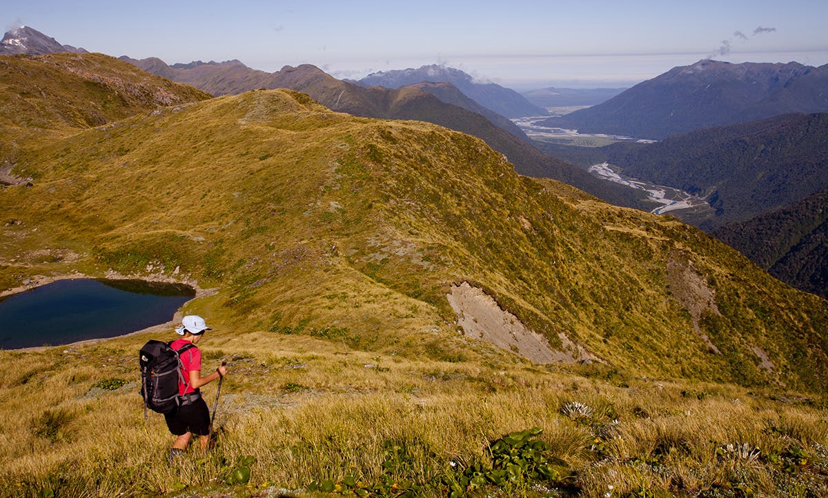
Being a weekend we had planned to camp on the tops rather than join the possible crowds at the small 10 bunk hut situated at just over 1100m. A short climb above the hut led to Kelly Saddle with its cluster of small tarns, but with plenty of summer evening remaining, we pushed on westwards in search of that ‘perfect tops campsite’. The route across these gently undulating grasslands is nowadays marked with the occasional pole, although not, I suspect, enough to find your way in bad visibility.
Visibility was no problem on this pleasant evening, being rewarded with extensive views over to the snowy peaks of Arthur’s Pass. Closer at hand we could glimpse into the deep, shady Seven Mile Creek leading to the Taipo and finally the glistening braids of the Taramakau snaking its way towards the setting sun.
The camp by a warm tarn among the tussocks dotted with late flowering mountain buttercups and clumps of creamy daisies was picture perfect, and the lure of Mt Murchison on the horizon stoked the fires of enthusiasm for yet more journeys over summer.
Plans of retracing our steps to the car parked down by Kelly Creek were easily cancelled in favour of continuing down the recently re-cut trail alongside Seven Mile Creek and into the lower Taipo Valley. One of the many pleasures of avoiding the more regimented and controlled backcountry trails in the New Zealand outdoors is the freedom to alter plans on a whim, without penalties from above.
It was going to be a long descent of about 1000m to the valley floor, but the morning views as we skirted a few attractive tarns down to the forest-clad Taipo encouraged us onwards and down. The fault-scarped spur that led from the tops to a marked track at the bush edge proved easy in good visibility, but could be tricky in cloud.
The usual knee-crunching, switchback track through a forest of twisted rata brought us out, after about two-hours, to the only river crossing on the entire trip. Seven Mile Creek was easy to boulder-hop before reaching the broad river flats of the Taipo Valley. It was time for lunch in the sun before putting heads down for the final 8km stroll along the partially washed out 4WD track back to the main highway.
There now only remained the problem of getting back to our car, some 26km along SH73. Marie-Luce proved to be a more suitable hitch-hiking lure than I, and before long she, along with a van load of young German guys, was heading away to, hopefully, pick up our car.