


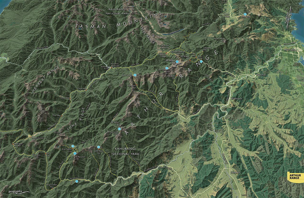

Straddling the north-eastern fringe of Kahurangi National Park, from the Takaka Hill summit to the Wangapeka Saddle, the Arthur Range is a major landmark in the Nelson Bays region of the upper South Island. It’s also strategic, having several notable access points through and around it from the Motueka Valley and on into the huge Karamea River basin.
The range itself is spectacular and comprises some of the most complex geological landforms in New Zealand, especially the fluted marble outcrops around the Twins and Mt Arthur as well as areas of glaciated karst. To explore the range and its passes is to uncover a wealth of routes and diversions into the Karamea or simply along the range itself.
1. Mt Arthur
The routes onto and around Mt Arthur, 1795m, are many and varied, as are the fantastic panoramas from the summit both into the hinterland of Kahurangi and out over the Nelson bays. There are large sections of karst landform below the summit and a spectacular array of alpine plants and flowers in early spring. Mt Arthur Hut makes a great base for a summit trip or exploring the fell fields above it.
2. Flora Saddle
The range’s main gateway, the steep torturous Graham Valley Road, one of the highest roads in New Zealand, grants excellent access right from the bushline to the Mt Arthur Tablelands, Mt Arthur, Lodestone, and the upper Takaka River.
3. Takaka Hill
Takaka Hill offers untracked routes onto the range. This is difficult country through untracked forest strewn with Takaka marble.
4. Wangapeka Track
At the southern-most extreme of the range runs the Wangapeka Track, from which there are numerous tracked routes onto the very summit of the range, making possible some fine range traverses or crossings into the Karamea.
5. Baton Saddle
This seldom-used, though tracked route, links the rough upper Baton River with the Leslie River on the western side of the Arthur Range. It provides access to the tracks through the Leslie-Karamea and onto the Tablelands. Flanagans Hut provides accommodation for parties crossing the range.
6. Kiwi Saddle
This low bush saddle and the nicely set and comfortable Kiwi Saddle Hut, have tracked access onto the range and neighbouring Luna Ridge. The saddle makes possible further exploration of the tops in these parts or access into Taylor Stream and on to Crow River in the Karamea basin.
7. Mt Patriarch
Lord of the southern end of the range the triple-summited Mt Patriarch, 1701m, is an impressive sight from almost anywhere along the range. It is an easy scramble from above Kiwi Saddle. The view covers almost the entire northern section of Kahurangi National Park.
8. The Twins
The steep razor-backed cones of the Twins lie just south-west of Mt Arthur and at 1796m and 1809m are the highest points on the range. They are also the most difficult to climb. Access is either from Ellis Basin Hut or Baton Saddle.
9. Mt Sodom and Mt Gomorrah
Two large domes on the range, Sodom and Gomorrah, 1565m and 1592m respectively, are relatively easily reached and climbed by traversing along the range from either the Chummies or Gomorrah tracks out of the Wangapeka Valley.
10. John Reid Hut
Wonderfully set in a small tussock basin on the south side of the range above the Wangapeka Valley, John Reid Hut has one of the best mountain and river views in New Zealand and also excellent access onto the Arthur Range which can be traversed either north or south from here.
