


- Time
- 3hr one way
- Grade
- Moderate
- Access
- Bethells Road, shortly before beach, at southern end. Constable Road, off Oaia Road, Muriwai Beach, at northern end
- Map
- BA30, BB30
Te Henga Walkway, Te Henga-Bethells Regional Park, Auckland
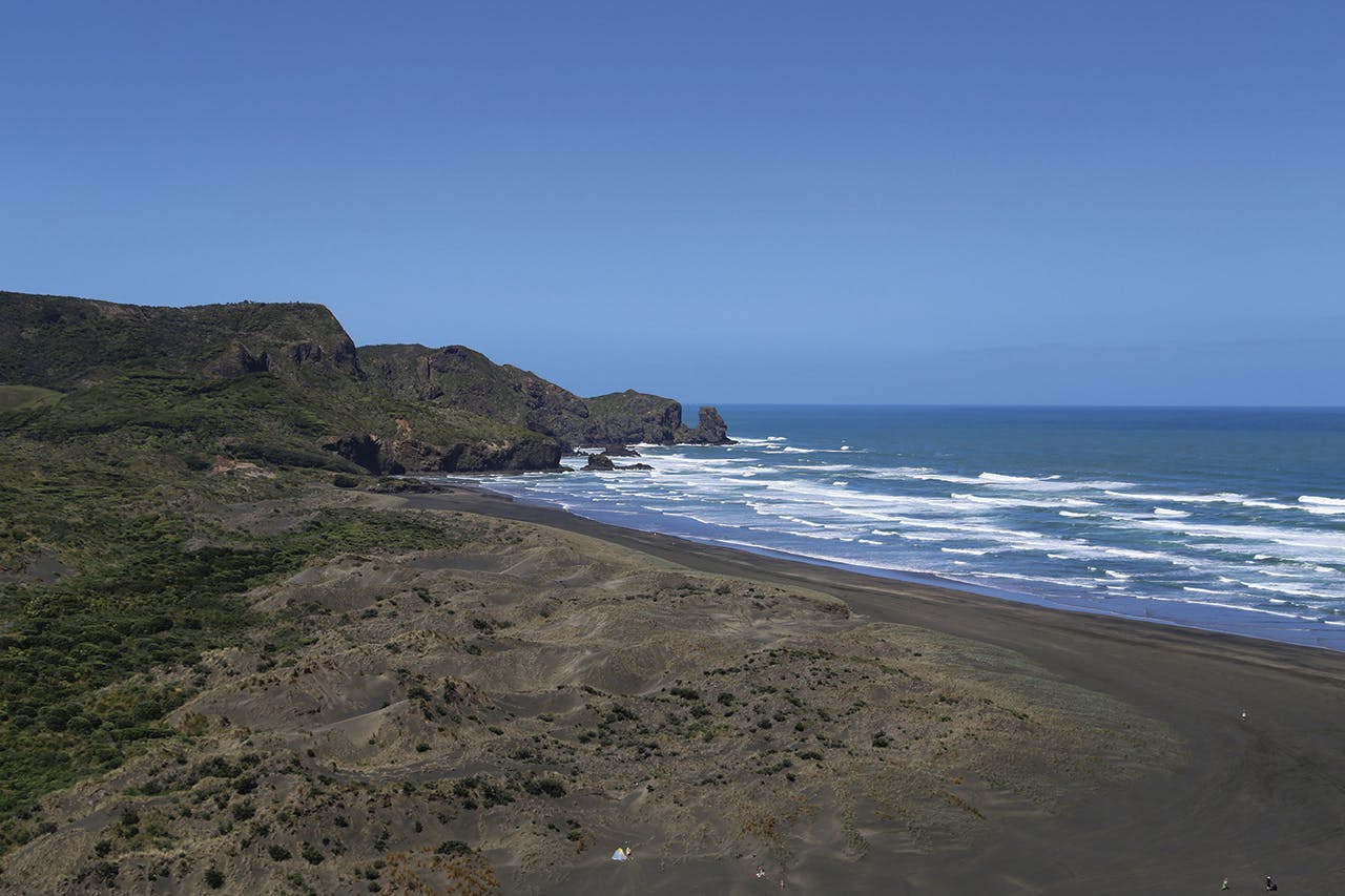
If you want dramatic cliffs, waves smashing into rocks and elevated ocean views then head to Bethells Beach (Te Henga) just 45 minutes from Auckland’s CBD.
Te Henga Walkway starts here, at a small car park around 1km before the beach. It makes sense (logistically, not environmentally) to take two vehicles and park one at each end, making it a three-hour one-way trip rather than a six-hour return.
I arrived just before midday on a warm morning in late spring. There wasn’t much space for parking, with families heading in the opposite direction to Lake Wainamu. I imagine it overflows in summer but there should be plenty of room at the larger car park at the beach.
I crossed the bridge over the Waitakere River and then a meadow where several rosella squawked in the trees. Then I reached the start of the climb through head-high bush.
It’s not long before you get a full view of Bethells Beach with hills of native forest to the east. The track drops towards O’Neill Bay and there’s the option to head down to the bay itself. Otherwise, the walkway rises right to the top of the cliff and there’s a spell where you have paddocks on your right and wild coastal views to your left.
The track drops a little and continues along the steep-sided cliff edge – you never actually reach the cliff top again until you reach the other end.
The beaches disappear and the coastline becomes less accessible. There are numerous lookouts where you can see waves pound the cliffs and water gush through arches. Lone rocks that were once part of the mainland get slowly battered into non-existence.
The track is worn and narrow in places and you need to watch your footing. There are times when it gets steep and it becomes muddy and slippery after rain. There are also many points where overgrown foliage falls over the track, which can make pretty impressive trip wire if you’re not paying attention to where you land your feet.
I walked on a day of constant sunshine and although there’s plenty of greenery, very little is over head height so I was exposed to the sun pretty much all day. I also ran out of water – there’s nowhere to refill so bring three litres if you’re walking the return route.
I stopped for a picnic just as the path heads inland towards Constable Road. This is the best spot for lunch, as you reach the cliff tops again and the views are quite wonderful.
If you’ve parked a second vehicle at Constable Road, it’s a short walk from here up a hill to the finish. But if you’re returning to Bethells Beach I would turn round as the path heads inland, while overlooking Bartrum Bay. You get a lot out of the return leg because you spot plenty more photo opportunities missed on the way in.
To vary the experience a little, I dropped down to O’Neill Bay, admired the rock formations and observed the gulls scurrying around the water’s edge. I crossed the saddle at Erangi Point before wading across the serene lagoon at Bethells Beach. Good coffee and muffins are sold at a car park kiosk before the short road walk back to the start.
The track is often marked as ‘easy’ on signs, but it’s not well maintained and steep sections mean it’s far from easy. But this takes nothing away from the fact that it’s entirely worth the effort for the spectacular scenery which you’ll find repeatedly rewarding throughout.
