


Every rock provides clues to its often dramatic and violent past. Matthew Pike heads to one of the country’s most geologically fascinating spots to meet geology’s answer to Sherlock Holmes
If you’re anything like me, you’ll pass interesting looking rocks on your outdoor forays and gawp at them for a moment. You’ll say something profound, such as “that looks cool”, or “oooh, weird!”. If you’re feeling a little more inventive you might liken it to a cheeseburger or the face of Elvis.
But I’ll very rarely stop to analyse how it might have got there and why it may have been cut into that shape. This is because I, like many trampers, haven’t the foggiest idea why this rock has landed here or even where it came from.
I’ve always wanted to know, but grasping a concept of the timeframes, scale and relative complexity of these things is always difficult, especially when reading from a book. I decided instead to try taking a walk with someone who knows about these things. Enter Bruce Hayward – geology’s answer to Sherlock Holmes.
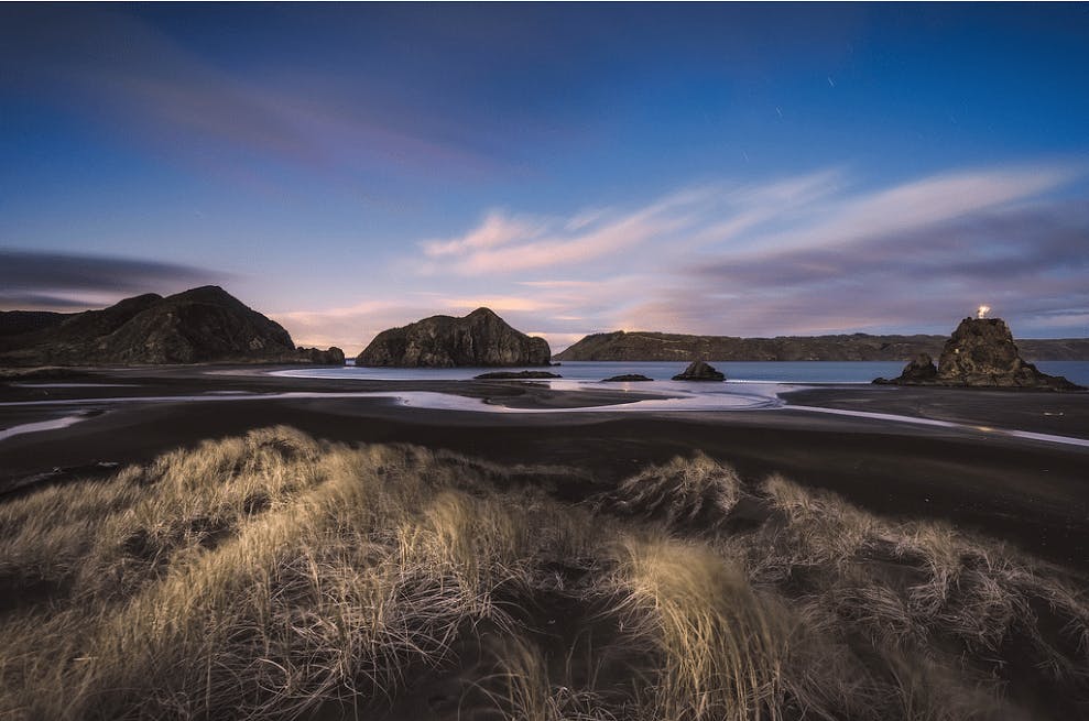
Looking across the now-vegetated sand field from the caves to Cutter and Ninepin rocks, Whatipu. Photo: Matthew Pike
Whereas most people can spot a curious shape, quirky pattern or splash of colour in a rock or a cliff face, Hayward finds clues as to origin, age and how it got here. It’s as if every boulder has its own biography.
Hayward specialises in geology and marine ecology and it’s fair to say he’s very highly regarded in such matters, having been awarded the New Zealand Order of Merit for his services to geological conservation.
Titles of work Hayward has been involved with, such as Recent New Zealand shallow-water benthic foraminifera: Taxonomy, ecologic distribution, biogeography, and use in paleoenvironmental assessment, suggested I might be somewhat out of my depth. But I was going to try and keep up.
“My favourite place is Whatipu,” Hayward said to me as we were planning a suitable location at which to meet.
That was good enough for me. Apart from the historical interest, Whatipu is a great tramping spot anyway. Situated on the south-western corner of Auckland’s Waitakere Ranges Regional Park, it combines the wild west coast with terrific harbour views and a curious sand field which now separates former sea cliffs from the ocean by up to 2km (more on this later).
But first, I needed to understand what had happened over the previous 20 million years. I found it easiest to think of it as a fairy tale from a land far, far away.
First, I had to imagine that the land on which I was standing, now Whatipu beach car park, was once 2km below the surface of the sea. Further out west stood volcanic islands which spewed unimaginable quantities of rock – everything from giant boulders to tiny grains of sand which, as you’d expect, would travel the furthest.
Closer to these giant volcanic islands, where Waitakere Regional Park now sits, a mixture of pebbles, cobbles, boulders and grains accumulated – what geologists call conglomerate. These flowed down the underwater slopes of the volcano towards where Auckland is now. The largest slurries of rock and water flowed further than most, depositing layers of volcanic grit. One deposit can be seen behind Auckland’s Parnell Baths.
Over time, earthquakes lifted the Waitakeres, while sea eroded them down so that five million years ago they were merely a coastal plain. Since then, they have been pushed up to their current height – up to 500m or so. Meanwhile, the western parts of these great volcanic islands have been eroded away by the pounding Tasman Sea.
There has of course been plenty of volcanic activity around Auckland since the great eruptions out west 17-20 million years ago. But these are little more than spots squeezed on the face of these giant volcanoes of the past and the huge areas they covered with debris. Think of Rangitoto, Mt Eden, Mt Mangere and company as being a bad case of acne – that’s the scale we’re talking here.
“What we see now is very much eroded to give us a window into the past,” says Hayward, who first led me to Paratutae Island – a huge block with cliff faces and overhangs offering stark clues to those in the know. It’s largely made up of the pebbles, boulders and cobbles you’d expect from the ancient lava flows of those great volcanoes. And within this are steeply sloping layered lines high up in the cliff face. These, says Hayward, were formerly on the sea bed, compressed and pushed up over time through earthquakes. “Each layer represents the sea floor building up through time. The compression created uplift and some layers would tilt as they were pushed up. This layer of seabed has been picked up, ripped off and has ended up on its end.”
My mind tried to comprehend the sort of force that could break up the seabed and thrust chunks of it up and on to their side, like smashing a biscuit with a rolling pin.
But Hayward was already pointing out another feature of Paratutae – the overhang common to many cliff faces on the west coast. I always thought the rock underneath had been eroded by the force of the sea. But Hayward explained it’s not as simple as that because the overhang is above the high tide mark, while flat shelves, popular ledges for fishermen to stand on, occur at the high tide mark.
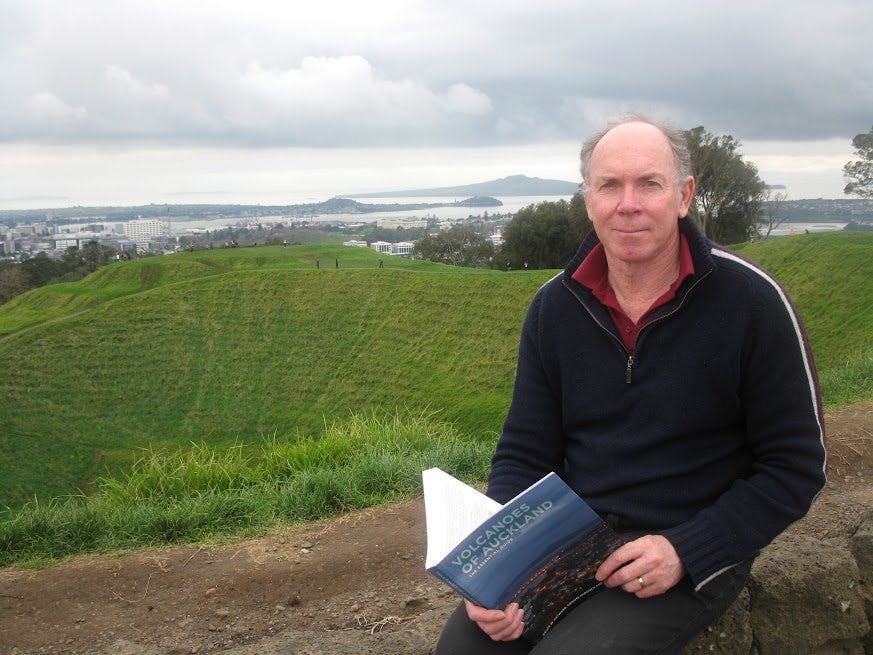
Geologist Bruce Hayward with one of his books, Volcanoes of Auckland. Photo: Matthew Pike
“Rocks at and below the high tide mark get wet twice a day, so don’t have time to dry out. Rocks above that get wet from spray, then dry out. As this happens, salt crystals grow and push their way between the grains which loosens the surface. Then water and wind wash these grains away.”
We wandered over to Ninepin Rock – a monolith that exists just below the high tide line. This, explained Hayward, is the eroded throat of a volcanic vent where some of the rocks were blasted straight up into the air only to land back in the vent, eventually blocking it like a bath plug.
I had numerous diagrams drawn into the sand giving me a visual concept of how all these features came to be. But it was time to leave the luxury of a sandy beach and head to the caves a kilometre or so north that are popular attractions for visitors. There’s plenty of exploring here for anyone with a headlamp. There’s a basic campsite nearby and one of the caves is so large I’m guessing you could comfortably fit 100 people inside. It’s this cave or, more precisely, the front of it, which Hayward was most keen to show me.
Above the entrance are what look like several shoots of rock pointing upwards. They’re of different colours to the surrounding cliff face; one a paler grey, another almost beige.
I’d seen these before on previous trips to the caves, but had always educatedly dismissed them as ‘different bits of rock’. These shoots, explains Hayward, contain pumice rock – frothy lava that has been blasted into cracks by nearby eruptions, forcing them open, before rapidly cooling and solidifying.
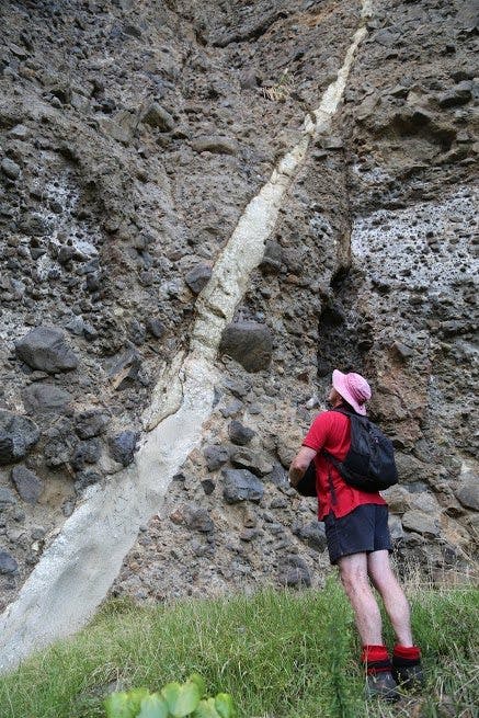
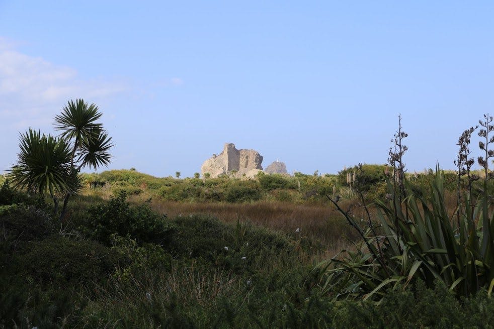
A great example of a pyroclastic dyke-rock that has been blasted into cracks by volcanic force. Photo: Matthew Pike
Whatipu has numerous examples of this. There are even rocks now separated from the cliffs that were formed this way with the softer surrounding rock now eroded from existence by the sea. But the examples above the cave were the most striking that I saw.
These pyroclastic dikes, as geologists call them, may have formed up to 20 million years ago, but not every formation around here is so ancient. Standing in front of the same cave, you can hear the distant roar of the ocean more than a kilometre away. It’s hard to believe that as recently as the 1920s, the sea would enter this cave at high tide. Since then a sand field has built up and spread further and further out into the ocean. Soon, there was enough vegetation on it for farmers to graze their cattle. Now the cattle are gone, shrubs have grown and the sand field is swampy.
The question is, why is it there? Not all geologists agree about this, but Hayward has his own theory that stems from the Taupo eruption of 1800 years ago.
“The sand built up in a short period and we know from history and maps that there used to be an island of sand and vegetation in the middle of Manukau Harbour entrance, just south of Whatipu, in the 1820s-1850s,” says Hayward.
There’s also reliable evidence from local Maori that there was a big build-up of sand with vegetation and freshwater lakes full of eels south of the harbour in the 17th and 18th centuries. This land is known colloquially as The Lost Land of Paorae.
Hayward says if you calculate that same rate of sand movement back 1800 years, it would take you to the mouth of the Waikato River.
“We know a dam formed across the mouth of Lake Taupo after the eruption and, when that gave way, breakout floods would have carried huge volumes of sediment down the Waikato River. To me it seems quite logical that the sediment is moving progressively northwards with longshore drift.”
Even since Hayward started visiting Whatipu in the 1970s he’s seen a build-up of sand to the north. “It has now filled up a lot of Karekare Bay,” he says. “You could never walk south from Karekare past Karekau Point across the sand, now you can get across at any tide.”
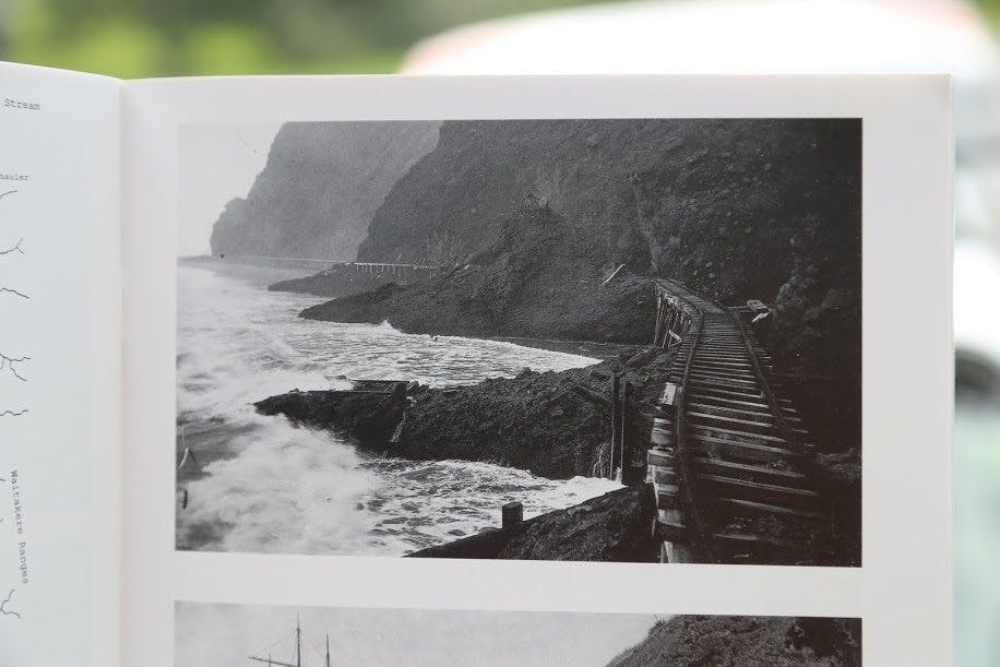
This image from 1916 shows the sea reaching the Whatipu caves. Today a 1km- wide sand field separates sea and caves. Photo: Auckland war memorial museum library
Hayward says there’s even evidence of sand build-up at Piha, as you can now walk out to the level with the front of Lion Rock at low tide – something you could not do in the past.
This means that in the not too distant future such beaches as Karekare and Piha could look vastly different to how they look now. “In 50 years I expect Karekare to look different and I expect the sand flats at Whatipu will erode away again as they move north – it’s only transient,” says Hayward.
“One day, my grandchildren might be able to walk on a sandflat from Karekare to Piha.”
