


To mark Wilderness magazine’s 30th anniversary, current and past editors and contributors scoured the archives for the 30 best trips we’ve published over the decades. This story, original published in August 2017, was included. You can find all 30 of the greatest Wilderness trips in the October 2021 issue.
Shaun Barnett contemplates risk and failure in the ever-changing landscapes of the Olivine Wilderness
It’s not the most heroic of starts for a journey to the mountains of legend. Hot. Sweaty. Crashing through beech forest. Swatting the occasional sandfly. Hauling uphill, hanging onto branches, our packs trying to drag us back downhill.
Our six-strong party was clambering through beech on a steep ascent towards the Barrier Range, headed for the isolated Olivine Ice Plateau, a holy grail of New Zealand tramping. Two of our number, Peter Wilson and Danilo Hegg, had stood on its fastnesses before. But for the rest of us, it was new country.
For almost as long as I’ve been tramping, I’d wanted to visit this hallowed ground, but never made it closer than sorties into the fringes of the Olivine Wilderness Area. Now I was finally headed for it, taking a direct approach that Peter had planned. From the Dart, we’d edged around the new lake, spent a night at Daleys Flat, then climbed onto the Barrier Range – a grand arc of mountains that separates the Dart from the Olivine country.
A small avalanche rumbled onto the Margaret Glacier.
Afterwards came a silence that I found uneasy.
From Seal Col, the plan was to traverse along the Main Divide through Desperation Pass and Possibility Col to Mt Gates, then descend into the headwaters of Blockade Stream, where a route led steeply but directly onto the plateau beneath Blockade Peak. Our route would possibly save a day over the less direct, but more commonly used approach via the Beans Burn, Olivine Ledge and Forgotten River Col. It would be a spectacular, airy traverse.
As we crashed through the forest, Peter led, making good progress through the mossy greenery, and speaking of the natural rock-bridge we’d soon cross. Like most side-streams in Otago’s schist country, the Margaret Burn is heavily gorged, but lay out of sight and sound, somewhere ahead. We had to find the rock-bridge, otherwise the gorge was impassable. Peter was keen to nail the navigation, and when we hit it bang-on, I could tell he was chuffed.
One minute we were walking across a forested slope, then the ground almost imperceptibly morphed into a large mossy boulder with a sizeable beech tree growing atop. “Look down,” said Peter. I looked down, and there was the Margaret Burn way, way below … so far below it was dizzying. Somehow, this large boulder had fallen into the narrowest part of the gorge, wedging there and forming a stunning natural bridge.
Beyond, it was easy travel through forest onto the expansive tops of the Barrier Range, where moderate slopes led to a high shelf, and one of the most astonishing views in the Southern Alps. The Dart Valley arced below us, with the new lake incongruous, and the peaks of the Forbes Range beyond. Above lay Seal Col and the blocky summits of the Barrier Range, but the Margaret Glacier most impressed us. Fed by ice falls on the Barrier Range, it curves into an impressive trench, lined with bluffs.
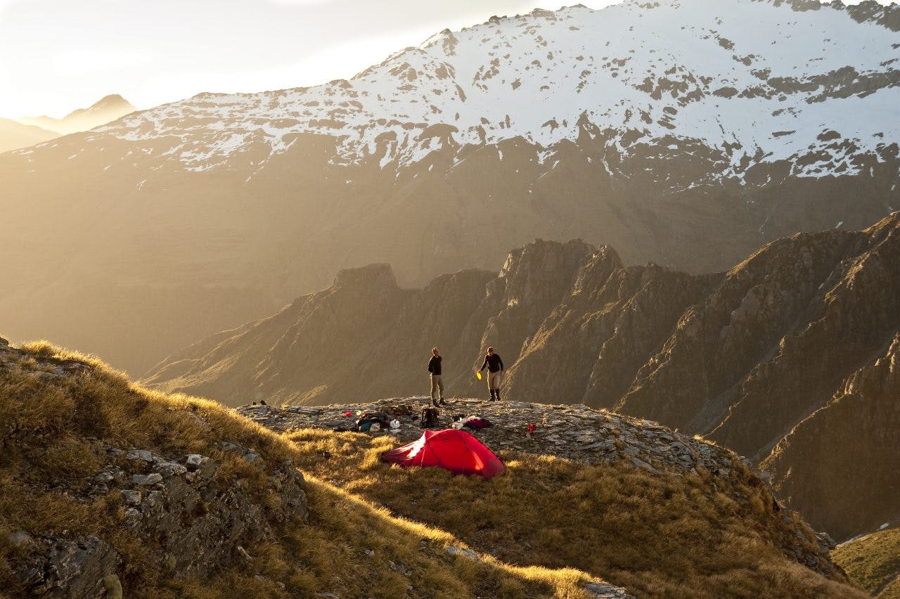
We pitched our tents here and I felt that old mixture of excitement and nervousness, a heady and slightly uncomfortable cocktail of emotions. Excitement at the thought of finally reaching the Olivine Ice Plateau. But nervousness, too. Ahead was a long day and I was intimidated by the bluffs that lay below our alpine route over the Barrier Range. A small avalanche rumbled onto the Margaret Glacier. Afterwards came a silence that I found uneasy. Evening wind, with some bite to it, blew in from the glaciers to the west.
At the campsite below Seal Col, Margaret Glacier beyond. Photo: Shaun Barnett/Black Robin Photography
We woke to low cloud in the valleys, and high cloud above. By the time we reached Seal Col, we found ourselves with little visibility.
Easy travel along the range led to a steep descent to Desperation Pass. Gemma, the youngest in our party, plugged steps on a curling sidle around Stefansson Peak. The clouds parted to reveal our first glimpse of the Joe Valley.
If the Dart offers mild tramping terrain, the Joe has an altogether different personality. Rough, almost ugly, a place of retreating glaciers, exposed rock, and almost unrelenting steepness.
In rapidly improving weather, we traversed Watkins, and stayed high with a long sidle into the large basin of the Derivation Icefall. It’s a curious feature of these trips that you carry a rope but hardly ever use it. Beforehand, you assure yourself that on any exposed or steep terrain you will protect it with a rope. But in reality, pitching is too time-consuming, especially for a large party. So you keep moving; in most places you’re sidling or traversing and a rope would be of limited use. Often there’s a lack of good anchors anyway.
Climax Peak rose above the Thunder Glacier, forming the eastern shield of the Olivine Ice Plateau. Once the Thunder Glacier offered a direct route, but these days it’s too broken to offer a viable passage. The glacier rumbled, giving voice to its name. Ahead lay a gentle but slow ascent in soft snow to Possibility Col and Mt Gates. While Possibility Col has an easy approach on the eastern side, to the west it falls away in horrendous bluffs.
“It should really be called Impossibility Col,” Peter quipped.
Higher up, we looked down on the Forgotten and Olivine River Flats and the many mountains crowding the horizon beyond. Jack Holloway had named the Forgotten in the 1930s, because the river and flats weren’t on maps, despite its discovery by Alphonse Barrington, an earlier explorer. Just below the summit of Mt Gates, now late in the afternoon, we peered over a steepening snow slope into Blockade Stream. We’d planned to camp somewhere on a tussock shelf down there, where a route gives access to the plateau between Blockade Peak and Key Rock.
But first we had to get down the steep slope, and down-climbing it with heavy packs did not look inviting. Danilo was unimpressed with the snow conditions. But after gingerly testing the snow, we began the descent. It was steep and slow, and we’d already been on the go for 11 hours. Using ice axes for security, our hands grew cold. But the slope eased, the snow receded and soon enough we reached rock and tussock.
We camped at a delightful perch, with three tents pitched on different ledges.
It had been the most exhilarating day of trans-alpine tramping. Evening light washed over our spectacular scene, with the distant Darran Mountains silhouetted. Seven kea came in to investigate. Unlike the vandals I’d encountered on Cascade Saddle, these were reasonably well behaved.
With the sun illuminating the plateau, we carefully examined our proposed route. Even though exposed, Danilo thought it looked fine, which was somewhat reassuring, and the angle seemed no steeper than anywhere we’d already been.
I didn’t like the look of the dirty smears of previous rockfalls, and a cone of old avalanche debris. Peter acknowledged he’d underestimated the seriousness of the route, and had previously believed the traverse over Stefansson was the crux. We debated the objective dangers; Peter and Danilo felt confident the route was okay, Chrissy was unsure, Gemma seemed completely unphased but didn’t express an opinion, while Darryn shared some of my concerns. A few small avalanches came down, which I could not help but feel were warning signs, despite them being to the right of our route.
We were only a half day from the fabled Olivine Ice Plateau, but the more I looked at the route, the more uncomfortable I felt, and the more conscious of my young family back at home. When you’re older, you feel differently about risk and I felt torn.
Eventually, with a heavy heart, I made a decision. It was the toughest one I’ve had to make in the mountains.
“Peter, I’m not going to the plateau. I’ll wait in camp.’
Darryn, perhaps more from friendship than conviction, said he would stay behind too.
Peter’s face showed understanding but clear disappointment, mainly for me. I could see how much it had meant to him to provide me this opportunity that I was now throwing away.
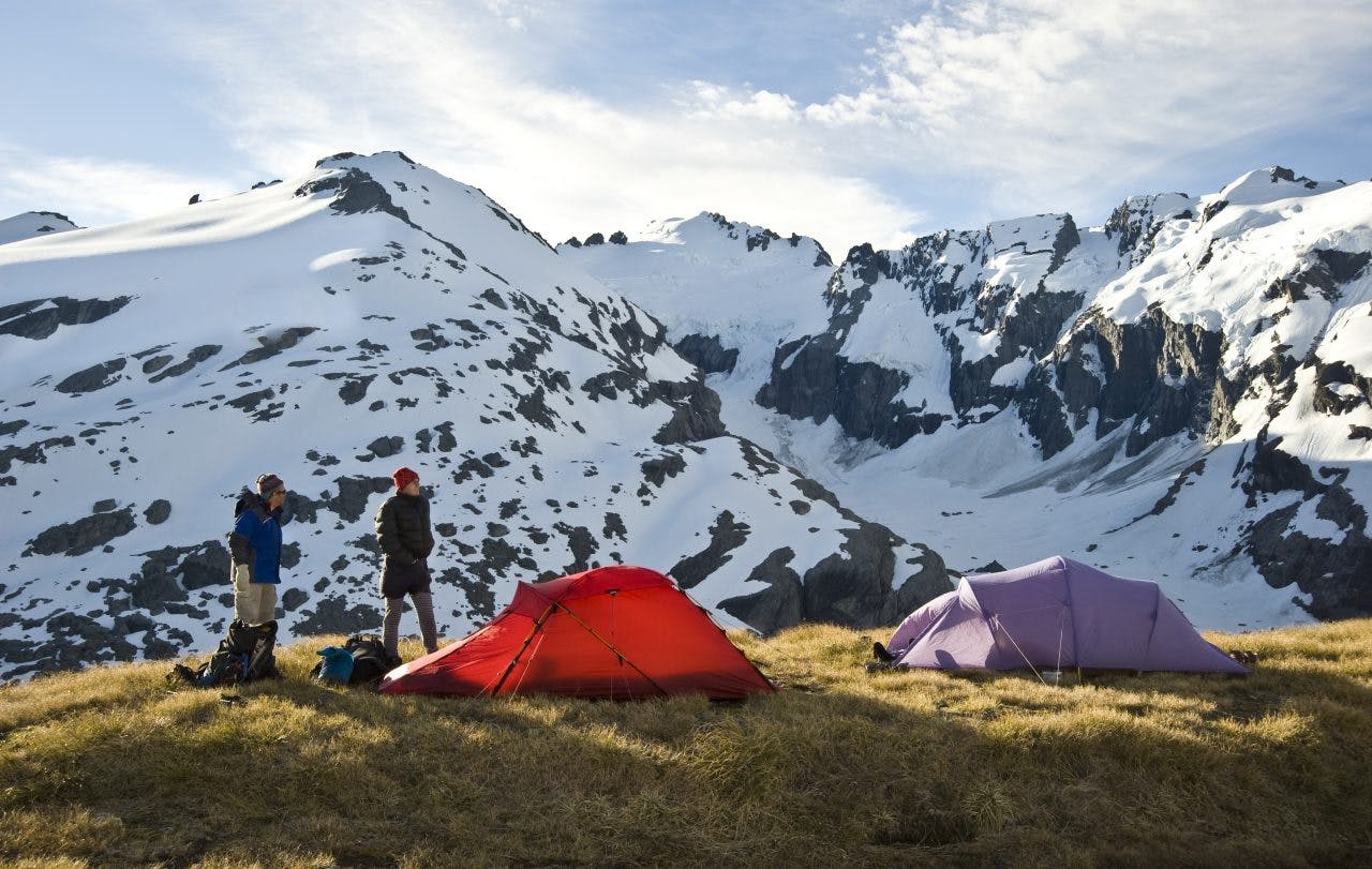
The colossal rockfall beneath Blockade Peak. Photo: Shaun Barnett/Black Robin Photography
“I can respect your decision, Shaun,” said Danilo, which made me feel slightly better.
Wimp. Always cautious. Weak. Worried about the risk. Not gutsy enough. These thoughts reverberated around my head in a familiar echo. But I’d made my decision, for good or bad.
The others rose early and were away by 6am. We wished them well. Gave them a hug. I worried for them.
Later, over a delayed breakfast, Darryn and I watched the four small figures inching their way up the slopes high above the valley. They seemed to be making slow progress; conditions were steeper and icier than expected.
An isolated bluff shed the occasional rock, and a constant wash of loose snow fell into a crevice behind it. It looked unstable, a huge overhanging block of three towers, below which the others had traversed in the dawn light. Darryn noticed a major fracture in the bluff. So it was no great surprise, but no less shocking for that, to hear a crack like a rifle shot, followed by the sight of one of the towers collapsing and sending up clouds of dust.
In the same unbelievable slow-motion show, the other two towers collapsed too, shattering into tons of rock fragments, falling and fanning out over the valley below. Refrigerator-sized rocks ricocheted over the lateral moraine wall, up which the others had toiled just a few hours before. One great chunk ploughed like a bulldozer over a glacier remnant. In the end, all that was left was a monstrous smear of dark rock and dust.
Darryn and I looked disbelievingly at each other, and in the absence of suitable vocabulary, uttered one-word expletives. Just an hour before he’d murmured that he didn’t think the rock tower had much longer in this world. But he’d meant a scale of months, or years, not 60 minutes.
Later, the others told us they’d seen nothing, and thought the sound had come from the Forgotten. The Olivine Ice Plateau is revered among trampers because of its remoteness and its well-guarded, steep approaches. Nevertheless, it’s never been beyond the capability of trampers with some fitness and mountaineering experience. In recent years however, glacial recession and a warming climate have meant that the traditional approach over the Forgotten River Col is getting steeper and harder.
The others reached the plateau in six hours, and made camp there. Meanwhile, Darryn and I lazed and listened to the occasional rockfall, with more than one big enough to kick up dust. We felt safe in our eyrie high above. That evening, we could see distant Lake Never glinting in the sun.
The following day was gloriously, almost impossibly, fine again – a run of weather to dream of. Our absent companions all climbed Blockade Peak, then Gemma, Peter and Danilo ascended Climax, the plateau’s highest peak – a fitting reward for their effort and daring.
Darryn and I went down to the foot of the rockfall, now that it had settled, amazed by how quickly the landscape could change; how something the size of a seven-storey building could collapse in less than a minute.
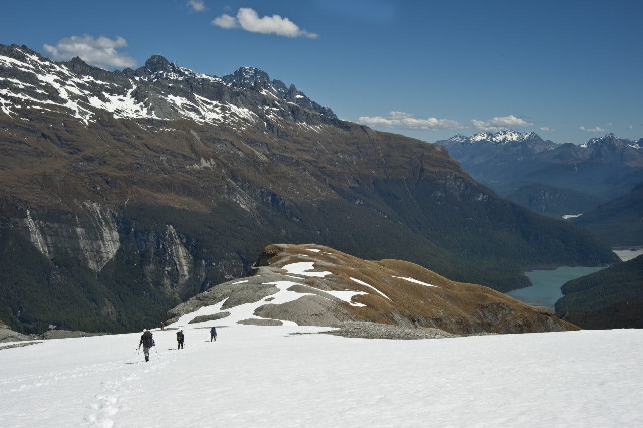
Descending slopes below Seal Col towards Dart Valley. Photo: Shaun Barnett/Black Robin Photography
We took day packs, climbed a small unnamed peak on the ridge south-west of Blockade Peak, descended to the Forgotten River, reached the flats, and found an excellent deer trail that allowed us to climb back up the forest in the lower Blockade Stream. By the time we regained camp, the others were back, telling of their shock at seeing the destruction.
We woke to the alarm call of Danilo’s Italian tenor voice. Intent to reach our campsite below Seal Col again, we made quick progress, and followed chamois tracks over the Derivation Icefall. At Seal Col, we could fully relax, knowing all dangers now lay behind us.
There shouldn’t be much more to tell, but we were in for one last surprise. What had been easy travel through beech forest on the uphill ascent proved, in the opposite direction, to be a maze of cracks and fissures in the underlying rock. We found ourselves having to backtrack from dead-ends, our progress grinding almost to standstill. That’s when Chrissy showed her superior skills with a GPS. Having tracked our upward route, she easily led us out of the maze and back to the correct route. Peter nailed the rock bridge again, then soon we were back in the easy terrain of the Dart.
That night we bivied on the river flats and watched the last light linger on the high peaks.
Earlier, I’d felt like a failure, but now that feeling had faded. We’d planned adventure, and certainly found it.
One not easily forgotten.
