


- Area
- Northland
- Distance
- 1.57km
- Time
- 2hr
- Grade
- Easy
- Access
- 30min south east of Whangarei along Riverside Drive, Onerahi Road and Whangarei Heads Road. Park at the Mount Manaia Club car park
- Map
- AX31
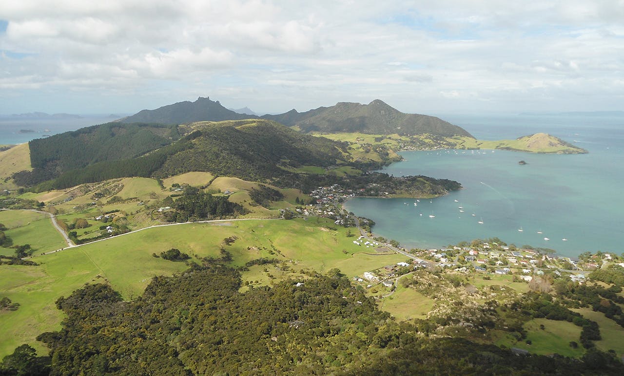
Manaia, Whangarei Heads, Northland
One of the joys of driving north to Whangarei is when you cross Pilbrow Hill and see, for the first time, the dramatic Whangarei Heads and Mt Lion in the distance.
These hills are not especially high, but they rise straight from the sea, they’re steep and most have pillar rocks poking out at the summit. This flexes their muscles, making them look like ‘proper’ mountains – unexpectedly prominent formations in a region of otherwise gentle terrain.
None are more impressive than Manaia. Its numerous ‘turrets’ at the summit give it a castle-like quality and the sheer drop on the southern side looks imposing from the car park at the base of the hill.
Fortunately, the track isn’t a direct route and instead snakes around the southern side before curving around the back to the top of the walkable section, beneath the turrets.
I found the track to be of excellent quality all the way to the top. It begins with a lovely view south from the early settlers’ memorial and continues into the bush at an easy grade.
Then the steps begin. I lost count at 52 but a child at the top declared there were 1079 in total.
Without the steps, I’m sure the track would quickly erode, judging by the steepness of the terrain and the number of people who walk it. With the steps, it’s just an hour’s slog to the top.
There were enough breaks between the trees to keep me aware of my surroundings and to enjoy glimpses of Mt Lion and the harbour. They were also handy for allowing the odd breather between staircases.
Close to the top, the gaps in the trees allowed the first close-up of the summit buttresses and I was soon walking among them, as if treading through an ancient city surrounded by remains of temples and palaces.
A wooden staircase leads to the highest point accessible to anyone without climbing gear or the remotest fear of heights.
The platform reachable by walking is situated next to one of the giant pillars, with a sheer drop to one side. The views are two-fold. To one side of the pillar, north-east over Whangarei Harbour towards the city, while to the other there’s a great view of Bream Head with the Hen and Chicken islands behind.
There is a series of narrow paths that lead around the summit taking you right to the edge of bowel-turning drops. But the best view of the lot comes, not from the summit, but from around 200m from the top.
A young couple told me about this view as I began my journey back down. A clear but unmarked path heads left and, after just a minute or so, leads to a large, rock platform. From here, there’s a spectacular uninterrupted view to the jagged hills of Mt Lion and the islands, as well as the best view of the summit’s rock pillars. I’d already eaten my lunch at the summit, but I wish I’d waited until here because it’s a great platform to stop for a bite to eat and there’s a better chance of having it to yourself.
I rejoined the track and enjoyed jogging the endless steps back to the car. While the topo map shows an alternative route down the hill, this is now closed.
