


- Time
- Homer Hut to Gertrude Saddle 3hr. Gertrude Saddle to Gill’s Bivvy via Barrier Knob, Adelaide Saddle and Gifford’s Crack, 4+hr. Gill’s Bivvy to Hollyford Road via Moraine Creek track 7-9hr Homer Hut to Homer Saddle, 1-1.5hr. Homer Saddle to Mt McPherson 2-3hr. Mt McPherson to Gertrude Saddle via Traverse Pass 4-5 hr. Gertrude Saddle to Homer Hut 2hr.
- Grade
- Difficult
- Accom.
- Homer Hut (30 bunks) costs $15 for NZAC members and $25 for non-members. It’s located just off the Milford Highway before entering the Homer Tunnel. There’s a hut warden usually in residence.
- Map
- NZMS-260 map D40 Milford, Topo50 Map CB09
Shaun Barnett and mates undertake a tough trip through formidable terrain
Even on a two-dimensional map the Darran Mountains look formidable: the orange contours aligned so closely that they resemble thick strands of seaweed, curling and snarling across the whole map sheet. Aside from the thin red line representing the Milford Road, mountains choke the entire map sheet, packed shoulder to shoulder.
Darryn Pegram claims the Darran Mountains are incorrectly spelt. One too many ‘a’s and a missing ‘y’, he reckons. He likes to point out the Darran Mountains contain Fiordland’s highest peak, the glacier-gilded, fortress-like Tutoko. He also likes to point out that no Mt Barnett exists in New Zealand; there’s only a small Barnett Park in suburban Christchurch.
The Darran Mountains surround us at the New Zealand Alpine Club’s Homer Hut, a flat haven in this place of overwhelmingly vertical terrain. We’d debated coming to Fiordland on such a doubtful forecast, but Phil Penney remains optimistic. When you work in the mountains like Phil, you develop an acute ability to read a weather map. To me it looks like everything should be closed, but Phil can see windows of opportunity between the predicted fronts.
Overnight rain swells the nearby creek, but the day promises sun. We head up Gertrude Valley, peaks prying free of the dissipating cloud. Phil points out ‘Psychopath Wall’ on Mt Talbot, a thick band of merged contours up which climbers have forged new routes in recent years. On the valley floor, the travel is at first flattish, but higher up the route climbs steadily, arcing across the lowest slopes of Barrier Peak. Before reaching Black Lake, we pause to don crampons. Today, Black Lake is entirely white. After gingerly stepping over a water-filled crack on the icy lake edge, we walk across its flat, frozen surface.
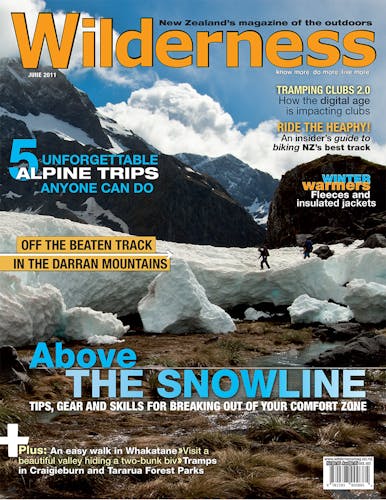
Valley cloud obscures the much-anticipated view of Milford Sound from Gertrude Saddle, so we plod on towards Barrier Knob. Phil promises a clearance, and at Barrier Knob his prediction becomes dramatically real. We lean over boulder jumbles staring down on Lake Adelaide, a long, black pendant of water seemingly directly below us. Everywhere rise dark, intimidating mountains softened only by the remaining puffy cloud, and – on the highest peaks – snowfields. The names of many peaks acknowledge Fiordland pioneers: Talbot, Lyttle, Grave and Gifford.
In the diorite and granite of Fiordland, Ice Age glaciers found a more resistant material than the greywacke and schists dominating the Southern Alps. The resulting topography is more starkly etched and less bludgeoned than ice-shattered mountains elsewhere. Brutally steep headwalls contrast with gentle valley floors. Waterfalls spill from half-carved valleys where once tributary glaciers fed into the main body of ice.
We debate briefly the merits of climbing nearby Barrier Peak before deciding to slip through the weather window and reach the lake before the promised rain. From Barrier Knob a moderately sloped ridge leads down snow then rock to Adelaide Saddle. On the saddle we contemplate the fearsome drop into the Gulliver River. Of it, explorer William Grave wrote: ‘It would be easy to reach the bottom in a quarter of a minute, but not all in one piece.’
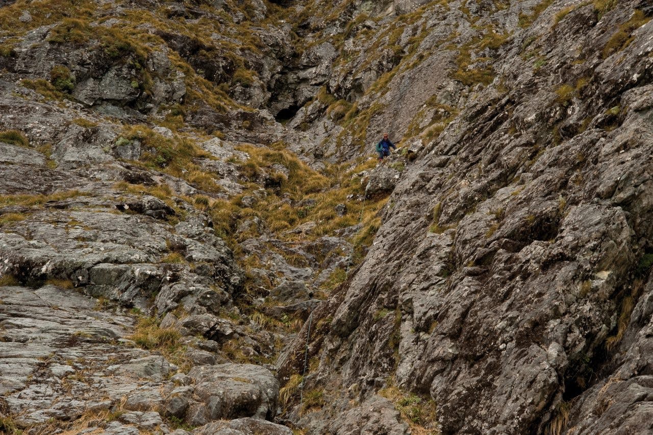
After a rest, we sidle a ledge to the start of the infamous Gifford’s Crack, a thin breach in a rock wall of otherwise foreboding defences. A C Gifford discovered it on William Grave’s Moraine Creek expedition of 1908-9, when he had stayed behind while the others, who were better climbers, attempted the wall head-on. In the revealing light of afternoon, Gifford saw the line of the crack highlighted by lengthening shadows. He recalled: ‘A quarter of an hour’s investigation showed that this route at all events presented nothing like such difficulties as the way the others were trying.
A coo-ee brought them back, and after a light lunch, we made for the narrow crack at the foot of the saddle, and in less than an hour, all four of us were on top of the saddle.’ It was a rare moment of quick triumph over Fiordland’s ramparts. We’re heading down the line of their ascent.
Crossing avalanche debris near Lake Adelaide. Photo: Shaun Barnett/Black Robin Photography
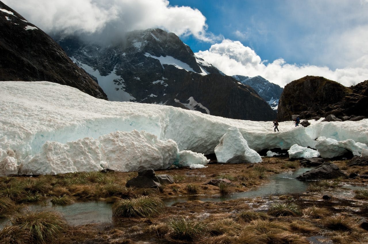
We take advantage of the recently installed bolt and anchor chain to safeguard our descent down the two pitches of the crack to where the terrain eases. Not as steep or desperate as imagined – plenty of climbers tackle it without a rope – but I was grateful enough for the rope’s slender assurance. Finally, we reach the head of Moraine Creek, which Grave considered to be ‘the largest and most beautiful branch of the Hollyford’.
The sun warms our lunch spot, but by the time we’ve tramped past Lake South America to Gill’s Biv, the next front looks imminent.
Gill’s Biv is the space beneath a massive erratic boulder, one that in eons past peeled off the rock walls behind and rolled to its present location, coming to rest at a fortuitous angle for climbers.
There’s ample room for the three of us, and climbers have spread tussock on the floor, even fashioned a cooking shelf and ledges for gear. It’s named after mountaineer Mike Gill, who during the 1950s and 60s climbed many routes in the Darran Mountains with Philip Houghton, including the west ridge of Sabre Peak. Gill recounts many of these climbs in Mountain Midsummer, one of the classic New Zealand mountaineering books.
There’s another rock biv about a kilometre away over an immense boulder field. It’s called Phil’s Biv, and is named after another Phil who climbed in the area: Phil Herron. Our Phil reckons Gill’s is better than Phil’s.
Sabre – what a name for a mountain! – is the peak in this valley that demands attention most keenly. Its great buttresses sweep up from the valley floor for hundred of metres before finally rounding off onto the helmet-like summit.
Lake Adelaide is at least a metre above its normal level, partially flooding the vegetation at its head. Giant alpine buttercups proliferate in the basin everywhere that sufficient soil exists. Elsewhere, clumps of bristly carrot and daisies protrude, and other patches contain prickly shield fern, snow totara, ribbonwood, flax and Astelia. Despite the abundance of alpine vegetation, everything has a temporary, almost scruffy appearance. In places, recent spring avalanches have wiped out swathes of vegetation, but already fern fronds protrude from the debris.
That afternoon, we sup chicken soup and watch sullen cloud sink low over the mountains. The rock walls get progressively blacker as rain licks them. It’s forbidding, big country, and I’m thrilled to be here at last.
There’s something quite exquisite about staying in a rock biv. It has the spaciousness, almost, of a hut, but with only one wall and a roof it has an exposure to the elements lacking in an enclosed space. There’s no barrier between you and the sounds, breezes and temperatures of the surrounding world – but at the same time you have a delicious sense of shelter when rain falls, and a sense too of solidness, which no tent can match. Phil says he’s been trapped here for days by storms, but stayed dry in almost any weather.
Later that night the rain turns to snow and we wake to see fresh falls gracing everything above the 1700m contour. Raincoats on, we head along rock ledges above Lake Adelaide in light drizzle, following cairns. Three rock wrens bob about in the sub-alpine scrub just as we begin to sidle around a large boulder field. This field, about two square kilometres in extent, is actually the moraine dam behind which Lake Adelaide formed after the glaciers melted. The lake’s outlet filters somewhere underground through this jumble of rocks to emerge lower down-valley as Moraine Creek.
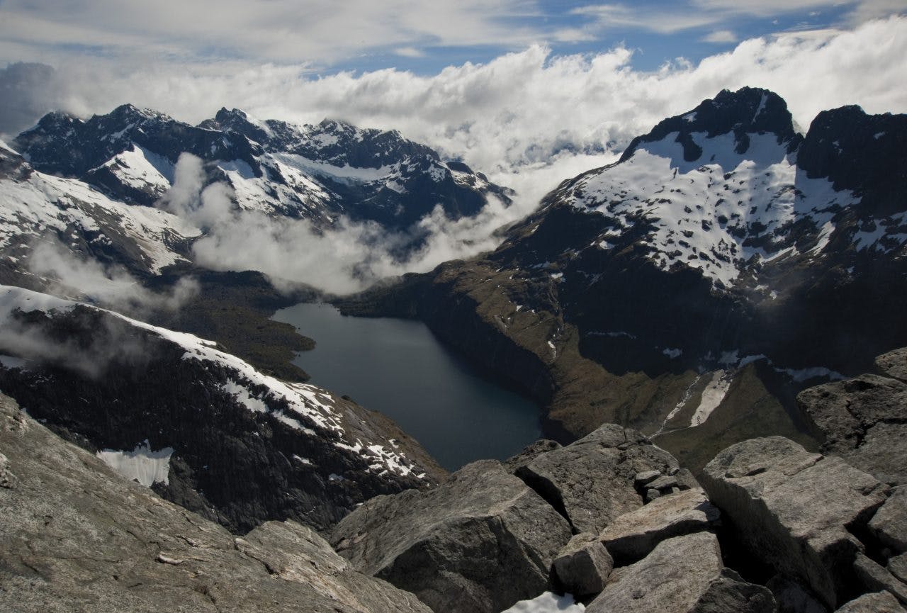
Phil has learnt from bitter experience not to cross the field, but to instead bypass it over a flat depression filled by a snow-fed tarn. We cross avalanche debris here, humbled by its extent.
Near the bushline we make the mistake of entering the bush too soon, and find ourselves negotiating windfall-ridden forest and huge moss-covered boulders. Real Fiordland bush; everything thick, wet and decaying.
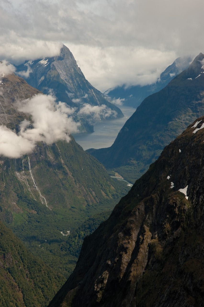
Dramatic view of Milford Sound from Adelaide Saddle. Photo: Shaun Barnett/Black Robin Photography
At Tent Flat we’re relieved, momentarily, to have escaped the claustrophobic bush. But typically for Fiordland, the nice gentle places are not quite solid: a sphagnum moss swamp covers most of the flats. As we squelch across them, the front seems to lose energy, and Revelation Peak reveals itself magnificently, its size amplified by the retreating mist. During the years 1954 and 1983, Moraine Creek Hut stood here until an avalanche wiped it out.
The rest of the day passes in a whorl of greenery. Prickly shield fern and mountain ribbonwood grow profusely beneath a tight canopy of beech. We follow the track, mostly, joining the dots between orange triangles. Finally, we’re at the long walk-wire over Moraine Creek, then soon after we’ve crossed the footbridge over the Hollyford River to reach the road.
We’re back at Homer Hut just as another front sweeps over Fiordland.
Homer Hut has had several pedigrees. The first, built by the Government Tourist Department in 1925, served as a base for hardy tourists attempting the Grave-Talbot route long before there was a road to Milford Sound. Dan MacKenzie and William McPherson did the hard yards, literally, lugging timber on foot from Howden Hut after the materials had arrived there on horseback up the Greenstone Valley from Elfin Bay.
In 1952, the NZAC relocated two Ministry of Works & Development houses used during construction of the Homer Tunnel to the present site to serve as climbing accommodation. In 1960, members of the Southland Section of the NZAC began building the present Homer Hut, which finally opened in 1965. Instrumental in the hut building process were Jim McFarlane, who’d climbed with Hillary, and Lindsay Stewart – who died just last year, aged 93. The Southland Section completed an extensive upgrade of the hut in 2006.
It’s McPherson’s namesake mountain that we’re headed for. A modest 1931m peak above Homer Saddle, it has stupendous views over the heart of the Darran Mountains. Phil tells us he once climbed it using a fire poker, as he found himself at Homer Hut on a gloriously fine day but with no gear. That rivals Allan Uren’s story of climbing Mt Taranaki with a garden hoe. Hoedown on Taranaki and a hand of poker with McPherson.
We’re away at the ungodly hour of 4:45am, the black sky and black peaks only made distinguishable by an outline of stars. After we leave the track at the Homer loop walk, a section of boulder-hopping leads to steeper scrambling to Homer Saddle. On the saddle, a cool breeze files through, threatening to make life unpleasant. We seek shelter on the lee of the saddle, which straddles either side of the Homer Tunnel: the Hollyford valley on one side, and the Cleddau on the other – both a stone’s throw apart.
The blocky ugliness of Mt Moir rears to the south, while northwards lies McPherson, up Talbot Ladder. It’s hard to believe that early in the 20th Century, this was part of a ‘tourist’ route between Milford Sound and the Hollyford Valley, pioneered by William Grave and Arthur Talbot in 1909-10. Prior to opening of the Homer Tunnel and road in 1954, trampers on the Milford Track had to depart Milford Sound by boat, or retrace their steps to Lake Te Anau.
Descending the two-pitch Gifford’s Crack. Photo: Shaun Barnett/Black Robin Photography
The Grave-Talbot route provided an adventurous alternative, but it was never popular. Occasional iron stakes still remain from when this route was secured by a wire cable.
By 8am we reach the snow apron of Mt McPherson and strap on crampons. Easy slopes lead to the summit, with a plethora of peaks rearing into view as we gain height. As the breeze has virtually died, we laze for a luxurious 30 minutes on the summit.
Even distant Aspiring is visible, a shapely anomaly beyond the regiments of Fiordland summits. Tutoko and Madeline stand out most as singular peaks, but Elliot and Castle Peak near the Milford Track rear distinctively too. Phil shows the line of an astonishing multi-week traverse he completed with Allen Uren along the ridge tops of all these mountains. It’s hard to imagine more spectacular peaks within the same height range anywhere else in the world.
After descending from the summit, we move together, roped up, headed for Traverse Pass, which is actually 56m higher than McPherson. Quite easy terrain, but not much run-out before we’d spill over bluffs. I’m piggy-in-the-middle today, a sometimes-testing position because of the need to move in unison with both ends of the rope. The ends of the rope don’t always move in perfect harmony, but piggy usually gets the blame. A steeper climb up the icy headwall leads onto the pass itself, where we can look down on familiar terrain: the tussock refuge of Gertrude Saddle.
Following an airy traverse on the corniced ridge crest, we discuss the option of climbing Talbot, but decide to descend.
Gertrude Saddle looks so close, but it’s two hours of slow descent on soft snow. My crampons ball up badly, but I’m not tempted to carry on regardless, and pause frequently to bash them free of snow with my ice-axe. It’s not a difficult descent, but the run-out is nil. Like McPherson, an apron of snow falls away to precipices. Fiordland mountaineering in a nutshell.
When we at last reach the sunny saddle, torpor overcomes us. A combination of eating and lazing too long means rigor mortis threatens. Finally the thought of liquid and lodging overcomes laziness, but the descent down Gertrude Valley seems harder than our ascent of just two days ago. The freshness has gone from my legs and we arrive at the hut ‘quite punched’ as Phil puts it.
At the Milford Sound pub, we consume celebratory beers, before driving back to Homer Hut for one last night. We leave Fiordland early, just as the sun catches McPherson. The fine weather won’t last, so we’re retreating east.
Later that day we stand on the summit of Single Cone, in the Remarkables, watching a front engulf the western Alps and Fiordland. We’ve danced between the fronts, in and out of windows, and left with some summits in our pocket.
