


- Time
- 4-5 days
- Grade
- Moderate
- Access
- From Rotoroa Village at the northern end of the lake. Take Gowan Valley Road off SH6 east of Murchison
- Map
- BS24, BT23
An alpine tarn with the purest water in New Zealand is just one attraction on this valley-hopping trip in Nelson Lakes National Park.
Nelson Lakes National Park undoubtedly provides a classical vision of the tramping landscape of New Zealand backcountry.
Yet although it is an archetype, it’s also unique in that it’s endowed with two large feature lakes, Rotoroa and Rotoiti, which both feed into the Buller River, as well as numerous alpine tarns and the remarkable Lake Constance, one of New Zealand’s highest and largest alpine lakes. With such attractions, I willingly embarked on a week-long trip with three long-time tramping mates to journey into the heartland of this inspiring national park. Our destination was Blue Lake and Lake Constance in the West Sabine Valley.
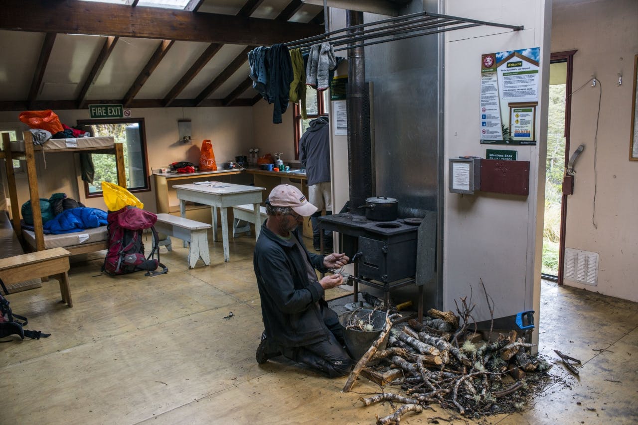
We began at Lake Rotoroa with the howl of a V6-powered water-taxi propelling us up the lake to Sabine Hut on a cool southerly day with intermittent showers and clagged-in tops. Suitably chastened by the cold and damp, we arrived at the empty chiller-like hut where we planned to spend our first night.
Barely 100m from the jetty, it is hardly a tramp-in, but we had already travelled from Christchurch and with nightfall not far off we chose an easy start with only the fire to light and dinner to cook.
Our planned route was almost the standard fare for this region; Moss Pass via the Sabine and D’Urville valleys, and one which I had first attempted as a novice tramper in my late teens one mid-winter. On that occasion we had faced extremely heavy snow, large avalanches, some of which roared down onto the valley floor prior to our arrival, and dangerous snow conditions, which ultimately forced a retreat, above the bushline. I subsequently crossed the pass some years later in the more benign conditions of autumn, and again one summer, but was still pleased to be back in this beautiful region and to visit my old haunts around Blue Lake.
None of my companions had ever ventured here and they were relishing the opportunity to explore it.
Our first full day’s tramp was a bit like a route march with cold, misty conditions, a good track to follow up the Sabine, but a long way to go to reach Blue Lake Hut. It was a case of head down, tail up and go for it. Not that we didn’t stop to enjoy the beauty of the region, take lunch at West Sabine Hut (and recover after Mike and Bryce were stung by wasps) before continuing into the dramatic upper canyon through which the West Sabine passes on its long journey to Rotoroa. The track here, bordered by waterfalls and huge bluffs, climbs steadily through forest, open meadows, and stunted beech to reach the large amphitheatre in which Blue Lake resides.
The nearby hut is set back among the trees west of the lake and after nine hours on the go, chilled and with darkness rapidly approaching, we were elated to reach its warmth and shelter.
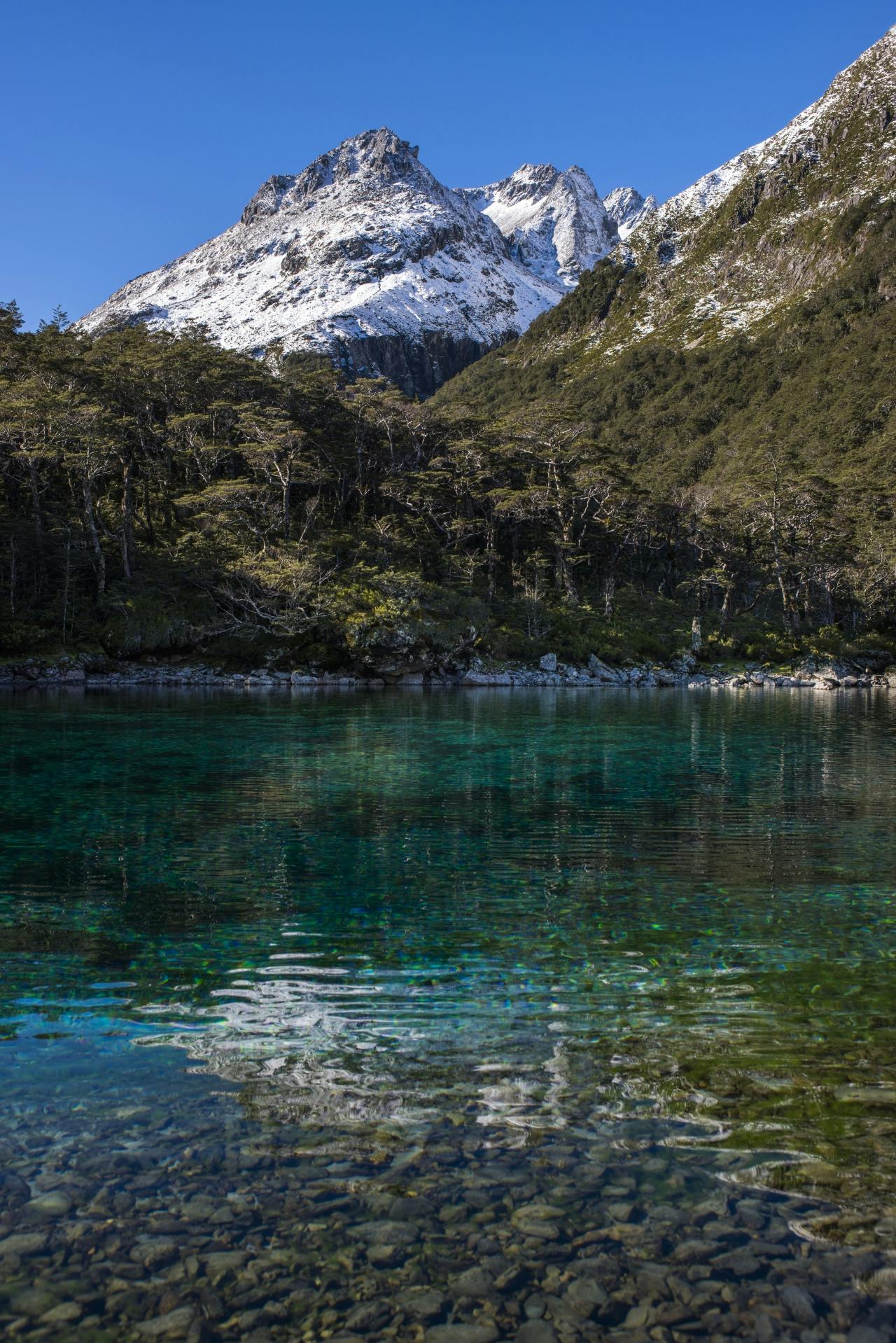
The crystal clear Blue Lake with Franklin Range beyond
The hut and lake are popular destinations, but no one was home when we arrived. We made short work of establishing our home for the night and heating dinner before rest as the cold night spread over the valley.
A moderately heavy snowfall in the past few days gave us pause to reconsider the route we were attempting over Waiau Pass and then Thompson Pass to reach the upper D’Urville Valley. Moss Pass had been the back-up option if time and weather didn’t allow the longer crossing, so despite the beautifully fine day which greeted us at Blue Lake Hut, we decided to take the shorter option and journey to the D’Urville via Moss Pass. Decision made, we were left with a day in hand to explore the environs of Blue Lake and Lake Constance.
On climbing to Lake Constance, our decision to tramp Moss Pass was vindicated when we encountered knee-deep snow at the bush edge and intermittently all the way to the lake with some thigh deep drifts to wade through.
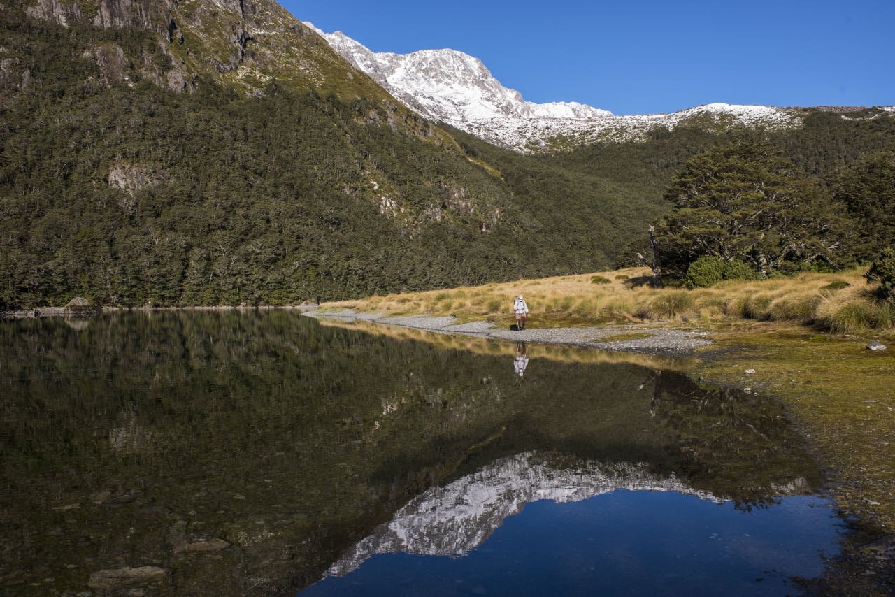
A faultless blue sky hung over the Mahanga Range and Main Divide when we reached the lip of the massive rock dam which impounds the lake. We gazed at its majesty and pristine setting amid bluffs and peaks; it’s a place I remembered well – for all the wrong reasons. Late one May I was forced to bivvy here with a party I was guiding over Waiau Pass on a five day trip from Lewis Pass to Lake Rotoroa. With deep powder snow on the pass slowing our progress, we had been forced to shelter beneath a tent fly. It wasn’t a pleasant night out, though we were kept entertained by a used car salesman who thought everything was a joke, including the camp and the complaints of his fellow trampers.
I am pleased to be back on such a magnificent day and with none of those complications, just three good mates to share it with and some exploring to do at lakeside to capture some images of the scene. It’s not hard with a gin-clear lake reflecting every mountain face in the vicinity, all newly decked with snow. We walked the shore and scrambled back up to the top of the dam through snowy blocks, teetering along a narrow rib to reach the crest.
We took a late lunch and returned to the Blue Lake area, 200m lower than Lake Constance and set directly beneath the western faces of Mt Franklin, the park’s highest summit. Blue Lake is a unique feature in a unique mountain landscape. Scientists have proven it to be almost optically perfect – approaching 80m visibility and thus some of the very purest water in the world, surpassing even the renowned Pupu Springs in Golden Bay. That’s quite a test, though when looking at the water on a superb afternoon it is not hard to attribute such absolute purity to it – it literally shines out of its 6m depths.
The lake is fed by the pure waters of Lake Constance which flows beneath the boulder dam, hence the pronounced filtering effect on the inflow waters. A rock tossed into the lake produces rippling iridescent waves which reflect off the bottom to bring about a pronounced shimmering in the water, added to which is my shadow etched right through onto the lake’s base gravels – a surprising effect.
We strolled around the lake to the hut for an easy afternoon before our assault on the pass the next day. The weather was holding so we were confident that it would go well.
We assembled outside the hut before dawn, on a dark and freezing morning, to begin the climb to the crest of the Mahanga Range where the narrow gut of Moss Pass, 1785m, lies. The 600m climb is relatively easy as the way is marked by poles, however, this does not lessen the angle which is steep to say the least and culminated in a 40-degree couloir packed with powder snow up which the route ascends to reach a small basin just 50m below the pass. The couloir was a challenge, as the snow was waist deep in places and required a great deal of effort, pushing up on the steep angle to overcome the terrain and powder. Still, the day was fine and clear with no wind so we made steady headway to the lip of the gully where we could haul out onto the sunlit pass.
It was amazing to be there with the length of the Sabine Valley stretched out below us like a long, green and gold alleyway, rimmed either flank with great bastions of snow and rock. Our perch was sublime and heightened further as we crossed the pass to view the wild, wide gulch of the D’Urville Valley spread out below the basins on the western side.
After a lengthy photo stop we began the trek, descending numerous snowed-up basins to the large bench below at 1500m. In such a setting on this day-of-days in the hills it was hard to leave the tops so we ate lunch and held a Mass near a tarn on a small knoll overlooking the chasm that drops to the D’Urville far below.
Later, we descended in full sun all the way to the bush edge where the twisting track dropped over and around small bluffs to enter the bush, crossing an idyllic mountain torrent which tumbled, vertically in many places, to the valley floor 800m below.
As we reached the valley, the angle eased and we could hike the last stretch to the valley floor at an easy stride until, suddenly, we were level with the river and traversing a wide terrace 50m above the flow. We crossed the swingbridge to the west bank and joined the main valley track to George Lyon Hut. There was a lift in our stride now as we hiked the last two kilometres to reach the hut by mid-afternoon. The pass was behind us and relatively easy valley walking over the next couple of days would take us back to Lake Rotoroa.
George Lyon Hut is named after the park ranger who constructed several huts in the region. It is one of the few surviving original two-room structures from the 1970s. It was originally named Ella Hut, as I remembered on my last visit, and has been preserved as a representative structure of this type of hut. It was a welcome sight and we clumped on inside, claiming bunks, and setting the fire and dinner.
The two-roomed ambience of the hut, with the log burner roaring well into the night, provided a cosy haven for the four of us as the night cold descended over the valley roofed with stars.
Thick frost covered every exposed surface the next morning, leaving us no option other than to move on quickly from George Lyon, down the valley through forest and glade until we reached Morgan Hut for lunch, thankfully in warming sunshine. Morgan Hut is a beauty: well sited, clean, modern, warm and with a great view of a large river flat catching all the sun that’s going.
We enjoyed the warmth of the interior, eating our lunch while eyeing the ominous entries in the hut book warning of major windfall damage in the lower valley after the massive storm event that hit the area and much of the West Coast earlier in the year. From the hut to the D’Urville Hut at the lake head, where we were headed for the night, is normally 3-4 hours walking time, but some parties had been taking 6-8 due to the windfall, so we approached it with care and a steady pace and at the first sign of damage escaped to the river flats and multiple fords of the D’Urville to avoid the worst.
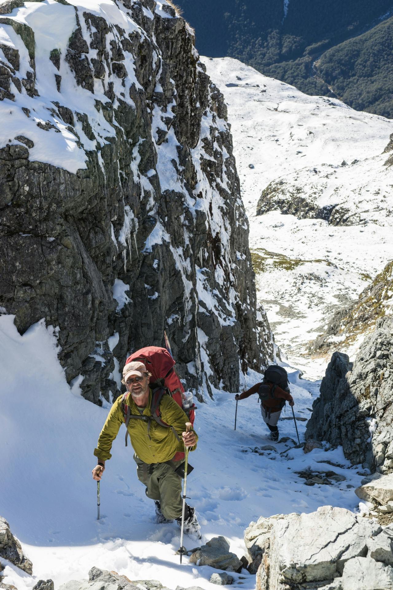
Climbing to Moss Pass.
The damage is plain to see from the river: whole hillsides had been laid waste, massive trees snapped at their base and thrown to the ground like so much matchwood. It was a sobering sight and I am pleased I was nowhere near the region when the storm struck, the sound and feel of such great trees falling and debris whirling through the air would have been frightful.
Despite a few minor setbacks with riverside windfall, we made excellent time and arrived at D’Urville Hut, which lies just across the bay from Sabine Hut where we began our journey five days earlier, in four hours.
The evening was calm and clear as we walked up to the hut. With the lake reflecting the beauty of the open tops, we enjoyed our last night out on this long route to the D’Urville.
