


It’s cold, wet, white, and dark. Now that you know the downsides to winter, you can begin to appreciate the good: it’s quiet, spectacular, spiritual, and white. These 21 trips – day, overnight and multi-day – are good for any time of the year, but really come into their own during winter. Prepare your pack, and go
7. A different perspective
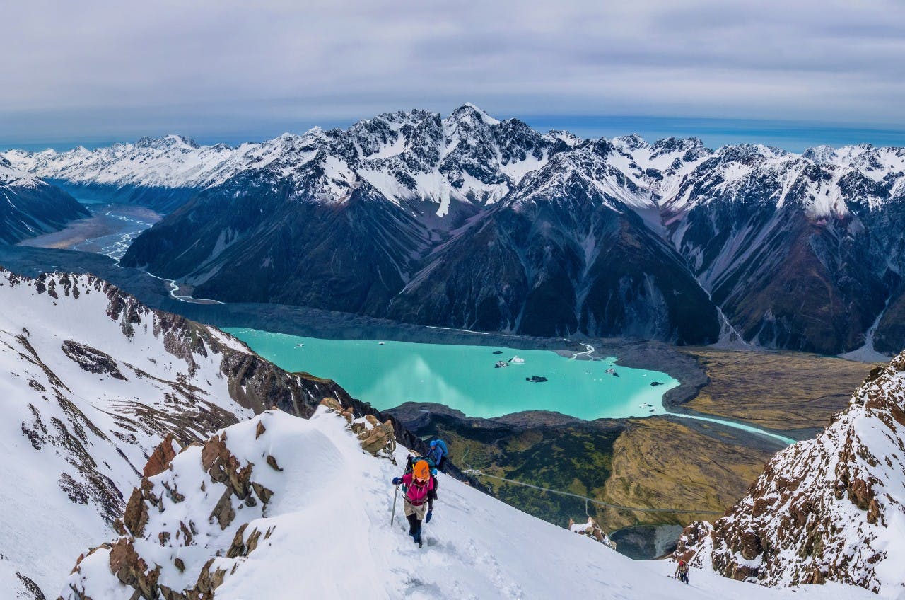
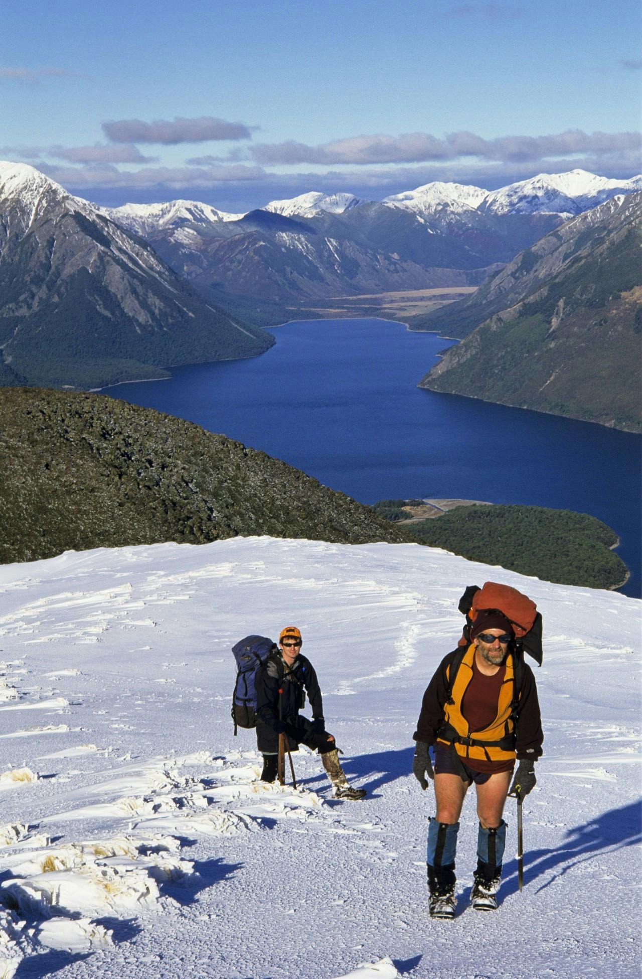
Mt Wakefield, Aoraki/Mt Cook National Park
DOWNLOAD THE MAP
If you’re willing to endure a short but more rugged scramble from the valley floor to the tree line than what’s required on the Mueller Hut route, then there’s another option, but without the crowds.
The route up Wakefield Ridge starts at Hooker Corner. A cairn signals where the rough trail heads directly upwards for about 200m until the bushline is reached and where the route becomes more obvious. This is alpine country and a winter trip requires crampons and an axe. Depending on conditions you may also need to use a rope further up. Awareness of avalanche risk is essential as you traverse snow slopes further up the ridge towards Mt Wakefield, 2058m.
Wakefield Ridge sits between the Hooker and Tasman glaciers, and allows expansive views of both valleys and the surrounding peaks. This location gives an even greater sense of being in the heart of the landscape than at Mueller Hut.
It’s also satisfying to reach the summit of Mt Wakefield – though Aoraki leaves no doubt from this vantage point as to which peak reigns supreme.
Grade Moderate-difficult Time 8-10hr return
8. An accessible winter summit
Mt Richmond and Mt Fell Hut, Mt Richmond Forest Park
DOWNLOAD THE MAP
Mt Richmond is an accessible winter summit, and a good choice if the mountains further south have high avalanche loading. From Te Rou Road, a track leads up the attractive Timms Creek to a prominent river fork, where a big ascent begins. This track reaches the tops just shy of Mt Fell Hut; recently relocated and renovated by the Nelson Tramping Club. It overlooks Mt Fishtail.
Mt Richmond, 1760m, is a solid but straightforward climb beyond the hut (although crampons and ice axe may be required, depending on conditions). For those who’ve made transport arrangements, a traverse is possible over the mountain to Richmond Saddle Hut, where a track leads to Top Valley.
Grade Moderate Time Te Rou Road to Mt Fell Hut, 6-8hr; To Mt Richmond, 2.5-3hr return
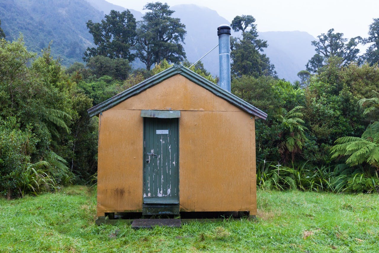
9. A warm bushline hut
Howletts Hut, Ruahine Forest Park
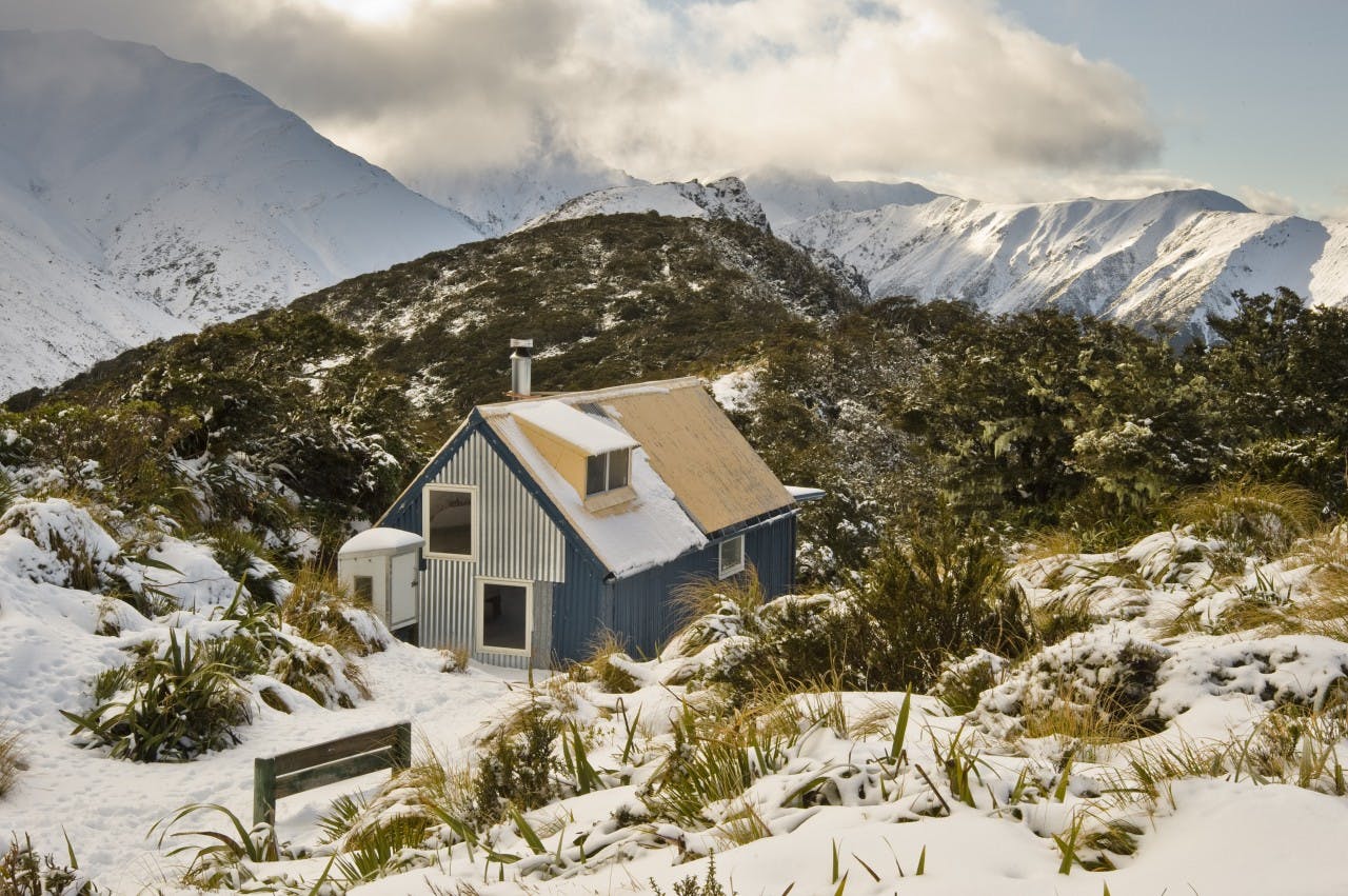
A winter wonderland at Howletts Hut. Photo: Shaun Barnett/Black Robin Photography
DOWNLOAD THE MAP
Howletts Hut is named after one of New Zealand’s pioneering trampers; William Howlett, who set up a ‘sort of alpine club’ in the 1890s, and spent innumerable summers botanising the local ranges. The club didn’t last long – Howlett was ahead of his time – but his name and influence did. So, when the Ruahine Tramping Club built a hut on Daphne Ridge in 1940, it was natural to name it after the man who had shown such interest in the Ruahine Range. When the Heretaunga Tramping Club took over the hut in the late 1970s, they undertook a major rebuild, and have steadily improved it ever since.
On the map, Howletts Hut looks not too far from the road end; but getting there can be quite arduous. The direct approach up the Tukituki River is slow bouldery travel. Far better, in winter, is to head in on a track from Kashmir Road via Daphne Hut. That leaves just a short spell in the river, and then the steep grunt up Daphne Spur. Even better still: climb to the tops near Longview Hut, summit Otumore, 1256m, then traverse north to Daphne Ridge and the hut.
Howletts lies right on the bush-edge; an attractive combination of orange and blue, with a steep gabled ridge and an effective potbelly stove inside. Grand views expand eastwards to Hawke’s Bay, but the best view is further along the ridge, where the Sawtooth Ridge appears in sharp profile. It’s a serrated bit of real estate in summer, but winter snow and ice lend it a grandeur as impressive as parts of the Southern Alps.
Grade: Moderate-difficult Time Via Daphne Hut track, 4.5-6hr, Via Longview Hut, 7-9hr
10. One hut, or two
Salisbury Lodge, Kahurangi National Park
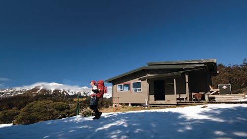
Salisbury Lodge. Photo: Ray Salisbury
DOWNLOAD THE MAP
With a maximum altitude of just over 1300m, hummocky tussock lands and a choice of huts and alternative tracks, this Cobb Valley route should be possible in most winter conditions. The access road up the Cobb is single track in places and winds up past the power station to an information shelter above the reservoir. It’s advisable to carry chains.
Climb gently onto Cobb Ridge. Below, the glacially-sculpted valley is now flooded by a reservoir, providing head to the power scheme. The Cobb area contains some of New Zealand’s oldest rocks and is a mosaic of geologically complex interactions.
At the junction with the Bullock Track, it’s decision time. If there is little snow it is possible to continue past Peat Flat to Peel Ridge, Lake Peel and Balloon Hut (14 bunks, serviced). There is avalanche danger on this section, so if in doubt, head left up the Bullock Track.
This then descends through forest to the Lower Junction. Heading up river, more options from the Upper Junction lead to the Flora area. A couple of rocky overhangs at Growler Shelter and Dry Rock Shelter are best suited to summer-time trips. Salisbury Lodge (22 bunks, serviced) is named in remembrance of Thomas Salisbury, who climbed from the Motueka Valley side in 1863. Gold prospectors followed from the 1870s, leaving some evocative names.
Returning to the Cobb, there is an option at Lower Junction to continue through the old mine near Asbestos Cottage – the haunt of legendary Henry Chaffey and his wife, Annie Fox. These recluses spent nearly 40 years living in the area and Henry developed a reputation for carrying loads of over 32kg, often including a case of whiskey. What better way to warm the cockles on a clear winter’s night.
Grade Moderate Time Road end to Lower Junction, 2hr; Lower Junction to Salisbury Lodge, 2.5-3hr; Lodge to Road end via Asbestos Cottage, 6-6.5hr
11. A wintertime standout
Macs Knob, Lake Sumner Forest Park
Climbing Macs Knob, resplendent in its winter coat. Lake Sumner beyond. Photo: Shaun Barnett/Black Robin Photography
DOWNLOAD THE MAP
An island-like mountain rising from the broad valleys of the Hurunui River, Macs Knob is not the sort of summit you might be drawn to in summer. But coated in winter’s residue, it stands out, and the top provides outstanding views of this part of the Southern Alps. The 1435m summit offers a direct line of sight up the Hurunui to Harper Pass, and the surrounding mountains.
Beyond the Hope-Kiwi Track, which skirts its base, there’s no track up Macs Knob, but the beech forest is relatively open and easy going, even when steep – and there are several spurs to choose from. Camping is possible on the gentle rolling tops, and there are multiple choices for the descent – perhaps directly to Three Mile Stream Hut.
Best access is from the Lake Sumner Road, where a 4WD route leads past Loch Katrine to Lake Sumner. Alternatively, tramp in via the Hope Valley, Hope-Kiwi Lodge, and then onto the Hope Kiwi Pack Track.
Grade Moderate (some off-track travel) Time 3-4 days. Permission for access from Lake Sumner Road required from Lakes Station
12. Flying high
Rapid Creek Hut, Westland
Four-bunk Rapid Creek Hut requires a bit of adventure to reach. Photo: Mark Watson
DOWNLOAD THE MAP
Get ready for a real ride on this trip. Rapid Creek Hut can only be accessed via a cage attached to a flying fox – one person and pack at a time.
The cage is suspended high above the roaring blue Hokitika River and it’s a nifty way to reach the small hut on the far side after tackling the rough track from the road end.
This is deepest, darkest Westland where big rivers, bold mountains, tall forest and plenty of rain are standard fare. Hopefully you won’t have too much of the latter, but going in winter, when there is often long fine, but cold, spells of weather, will up your chances of a successful trip.
The four-bunk hut is small and a bit damp at times, so don’t bring a crowd.
Keep a sharp lookout around Rapid Creek for pairs of blue duck – the birds are often seen here.
Grade Easy Time 2-3hr
13. Bush bash adventuring
Kaitarakihi, Coromandel Forest Park
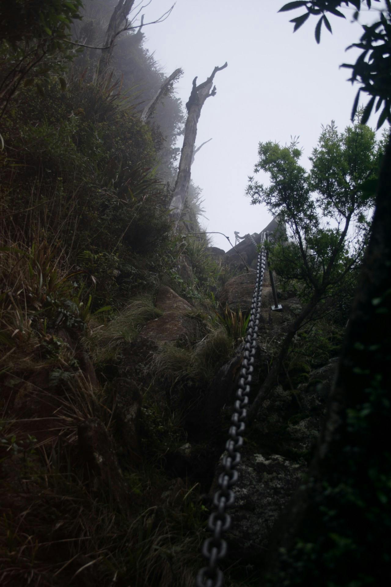
One steep climb requires use of this chain. Photo: Alistair Hall
DOWNLOAD THE MAP
At the crest of the Kopu-Hikuai Road is a parking area and track to Kaitarakihi, 852m.
The track is on a three-year maintenance cycle, so depending when you go – just before or after it has been re-cut, you could be in for a bit of bush bashing.
Don’t be deterred, this is an adventurous day walk through dense native forest, over slippery tree roots and even includes a chain to haul yourself up a near vertical rock face.
The track climbs from the get-go and the first 500m is a good warm up to access the ridgeline. The route then undulates as it follows the ridge towards Kaitarakihi. From the road, the ridge and peak look impressive, but confined to the bush vantage points are few and far between.
Supplejack grows in abundance on all sides making any off-track excursions to the side of the ridge a battle.
An hour in is the junction with a track leading east to the Devcich Kauri – an ancient hollow kauri. The track to Kaitarakihi then alternates between steep downhill and steep uphill, often clambering down near vertical ledges.
Emerging from the forest, a steep rock face appears. DOC has installed a large chain to aid the scramble up. This is the highlight of the tramp: exposed scrambling with great opportunities to take photos. The track then continues its merciless rise to the summit of Kaitarakihi.
The summit has a small clearing that should just about fit a tent – something to consider if you wish to carry on over the range to the Kauaeranga Valley or to Broken Hills.
