


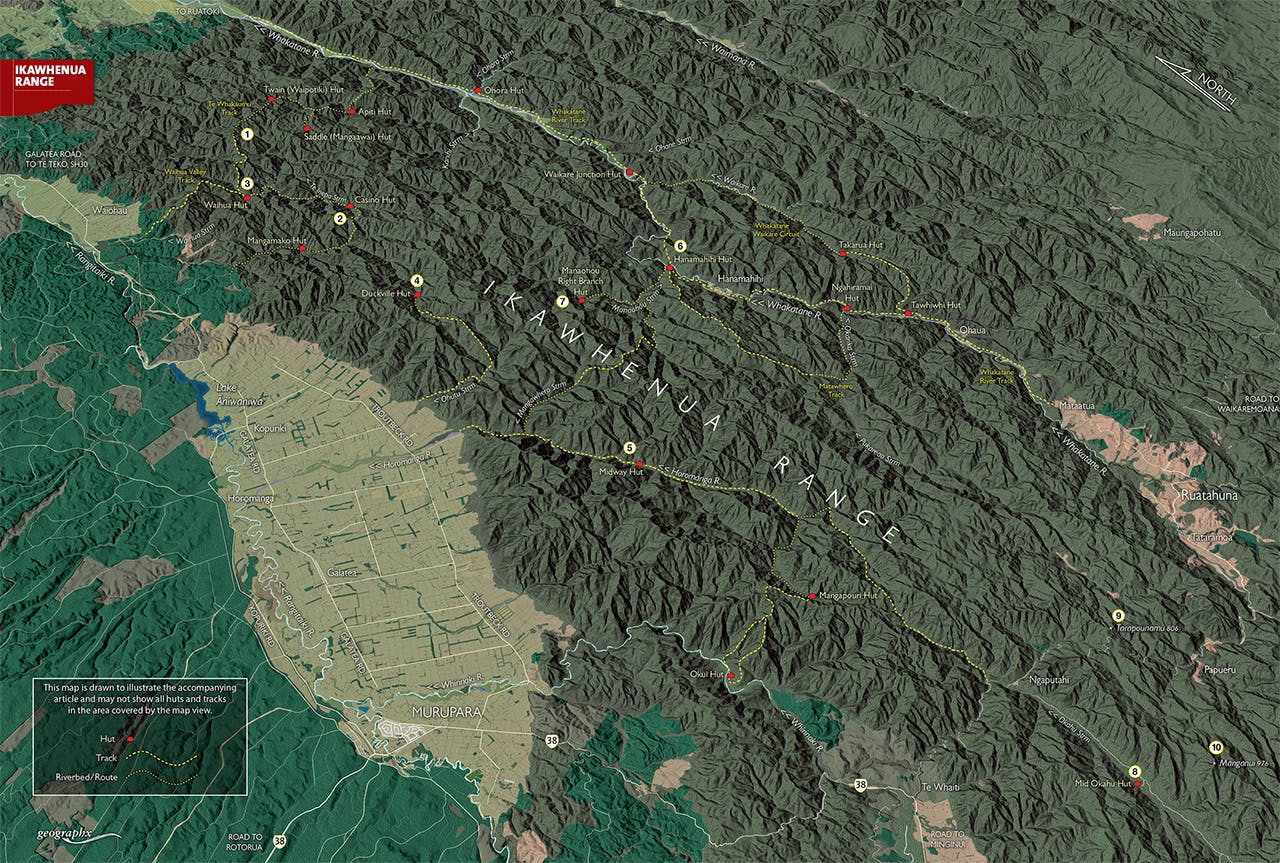

With more bends in it than an anaconda, the Ikawhenua Range snakes through the western side of Te Urewera. The range is almost entirely forest covered, with most peaks rising no more than 900m. Dividing the Rangitaiki and Whakatane Valleys, it stretches for some 85km to end at the north-eastern edge of Whirinaki Forest Park. Near where it joins the Huiarau Range, the other major spine of Te Urewera, is the Ikawhenua’s highest peak, Manganui. According to Te Ara, the full name of the range is Te Ikawhenua o Tamatea, meaning ‘the land of Tamatea’s fish’, linking the area to Tamatea of the Takitimu canoe.
Curiously enough for New Zealand, where westerly rainfall dominates, this part of Te Urewera gets less rainfall than the eastern part. Most of the range is un-tracked dense bush, dominated by red beech near the range crest. A lack of clearings or other identifiable landforms makes for challenging tramping and hunting. However, a smattering of huts exist on or near the range, and it’s crossed by a few tracks and also SH38.
Soon after the Urewera National Park was established in 1954, the Forest Service built a large number of deer culling huts, which to this day remain the dominant type of hut in the range. Indeed, the Urewera boasts more huts than any other area in the North Island except Ruahine Forest Park.
1. Te Whakaumu Track
This track links Waihua and Twain (Waipotiki) huts, the latter being the northernmost hut of the Ikawhenua Range. It’s also the only section of track that follows the range crest for any distance.
2. Casino Hut
This basic but well-maintained three-bunk hut lies above a prominent fork in the Te Inepa Stream, at a remote location west of the main Ikawhenua Range. It’s reached either from Mangamako Hut or Waihua Hut; both routes involve considerable tramping in creek beds. Beware you don’t overshoot the hut, as its location is not obvious.
3. Waihua Hut
Waihua Hut (four bunks) lies deep in the forest, above Waihua Stream, and is reached either by the Waihua Valley Track from the west, or the Te Whakaumu Track from the north-east.
4. Duckville Hut
This four-bunker is reached by following the Ohutu Stream, near Galatea, then picking up the track at the farm-bush boundary. Allow about 4-5hr.
5. Midway Hut and Horomanga Valley
Hunters have long known of the fine scenery of the Horomanga Valley, but trampers have been slower to discover it. Since the old Red Hut was removed, Midway has been the valley’s sole shelter. Like others in nearby Whirinaki Forest Park, it’s a design curious to the Urewera region; a long rectangle with capacity for nine: three bunks, each stacked three high.
6. Hanamahihi Hut
Hanamahihi Hut is one of several larger huts on the Whakatane River Track. With 10 bunks, a wood stove and a veranda, it boasts good views over the nearby river. It’s one of several huts on the 4-5 day Whakatane-Waikare tramping circuit.
7. Manaohou Right Branch Hut
This six-bunk hut is set in a small clearing in the mid-reaches of the Manaohou Stream, a major tributary of the Whakatane that has its junction near Hanamahihi Hut. There’s no track as such to the hut, but like many Urewera routes, trampers or hunters just walk up the creek bed.
8. Mid Okahu Hut
This hut is that rarest of things: a road-end hut that has survived. It’s most often used by hunters, but could make a late-night shelter for trampers en route to the tracks of Whirinaki.
9. Tarapounamu 806m
Tarapounamu marks the nearest named point to SH38, one of the most scenic forest drives in the country, where it crosses the Ikawhenua Range.
10. Maunganui 976m
This isolated, bush-clad summit rises above Okahu Stream and is the highest point of the Ikawhenua Range. A few kilometres south of here, the range intersects the longer and larger Huiarau Range. There’s no track to the range crest here, and very few people probably make the effort to reach the summit.
