


- Area
- Oteake Conservation Park
- Distance
- 68.4km
- Total Ascent
- 4856m
- Time
- 4-6 days
- Grade
- Moderate
- Accom.
- Boundary Creek Hut, 8 bunks; Camping
- Access
- Off SH8, just south of Omarama, onto Broken Hut Road. Follow this to the signposted public car park. Between Labour Weekend and April 30, 4WD vehicles can be taken to Little Omarama Saddle or Omarama Saddle
- Map
- CA14, CA15, CB14, CB15
To mark Wilderness magazine’s 30th anniversary, current and past editors and contributors scoured the archives for the 30 best trips we’ve published over the decades. This story, original published in November 2015, was included. You can find all 30 of the greatest Wilderness trips in the October 2021 issue.
The immense Oteake Conservation Park provides tops tramping unlike anything you’ve experienced before
‘Somewhere different’ was the call for our annual week-long trip to the hills. Completely different.
Standing on the Hawkdun Range, the sun was setting behind Mts Aspiring and Earnslaw. With a view of almost every high peak of the Southern Alps, from Earnslaw to D’Archiac, and the truly vast and empty landscape of the Oteake highlands all around, I realised we had beaten all expectations.
At 65,000ha, Otago’s Oteake Conservation Park is immense. So much so that the barren, treeless, inhospitable landscape both appeals and repels. It appeals in that it’s relatively easily traversed and offers big views of big country. But the distances covered and exposure to the weather can be daunting.
Our tight-knit team of four made landfall at the summit of Little Omarama Saddle, 1357m, with the aid of a 4WD – cruising up the hill from the Mackenzie Basin flats to reach the park boundary and the start of our grand traverse of the ranges. We planned to circumnavigate the tops of both the Hawkdun and St Bathans ranges and return via a high track that links Little Omarama and Omarama saddles.
Surveying the distant tops of the St Bathans Range, some 20km away beyond the 1200m-deep gulch of the Manuherikia River, I had a moment’s cause for concern – was it doable? It’s not often you can see your entire route laid out before you at the start of a trip. More often it is mercifully hidden behind grand mountains and hidden valleys. To have it displayed like a virtual map was a little disconcerting.
Our first day went exceptionally well – from the easy climb to the base of the Hawkdun Range from Little Omarama Saddle, followed by a steep pull up the eastern face of the Hawkdun to reach the crest where we were surprised to see a fence. It was a fully rusted relic of the mustering days from which Oteake had emerged into a second life as a conservation park. And that was just five years ago. Such relics of this era litter the landscape where fences doggedly follow the ridge for kilometre after kilometre, coils of ruddy coloured wire appearing at random, and converted musterer’s huts providing shelter for all comers on the valley floors. These features, on flat ridges at over 1800m, would be a blessing in misty weather.
After topping out on the range, we scrambled over a couple of easy summits, all the time admiring the massive views granted of Aoraki/Mt Cook National Park and its attendant ranges away to the north before descending into the headwater basin of one of the unnamed large creeks draining the eastern flanks of the Hawkdun into the head of Otamatapaio River. These basins are also relics – this time of the intense glaciation which covered the peaks and valleys just a few thousand years ago. They also contain mountain tarns, the jewels of the Oteake. For such a barren, desiccated landscape you would expect water to be a problem. However, in almost every headwater basin on both ranges large tarns can be found about 100m below the range top and in some cases, as the ridges are often so flat, wetlands and streams are present even at ridge top level.
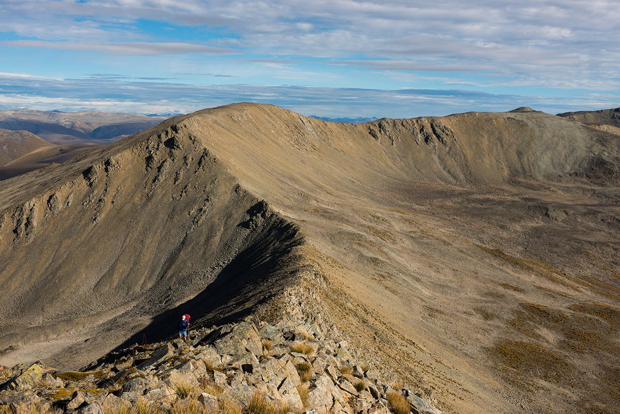
Oteake is full of surprises, as we soon discovered. Our campsite was a delight and quite alpine in nature with a view of outlandish proportions down the Otamatapaio River to Lake Benmore and its ranges.
Early light at camp on Hawkdun Range. Photo: Pat Barett
Our second day was a long one, yet not without numerous highlights, beginning with more of that big-time view; I just couldn’t get enough of it and could’ve stayed on the Hawkdun tops for days just drinking it all in.
We traversed an uncharacteristically steep-sided watershed, and made steady progress south of our campsite staying at or just below 1800m – the ubiquitous fenceline came and went, lakelets glittered in hollows and hectares of ‘flat’ dominated the range top as we headed further south. It was predictable but also energising, a real journey of discovery.
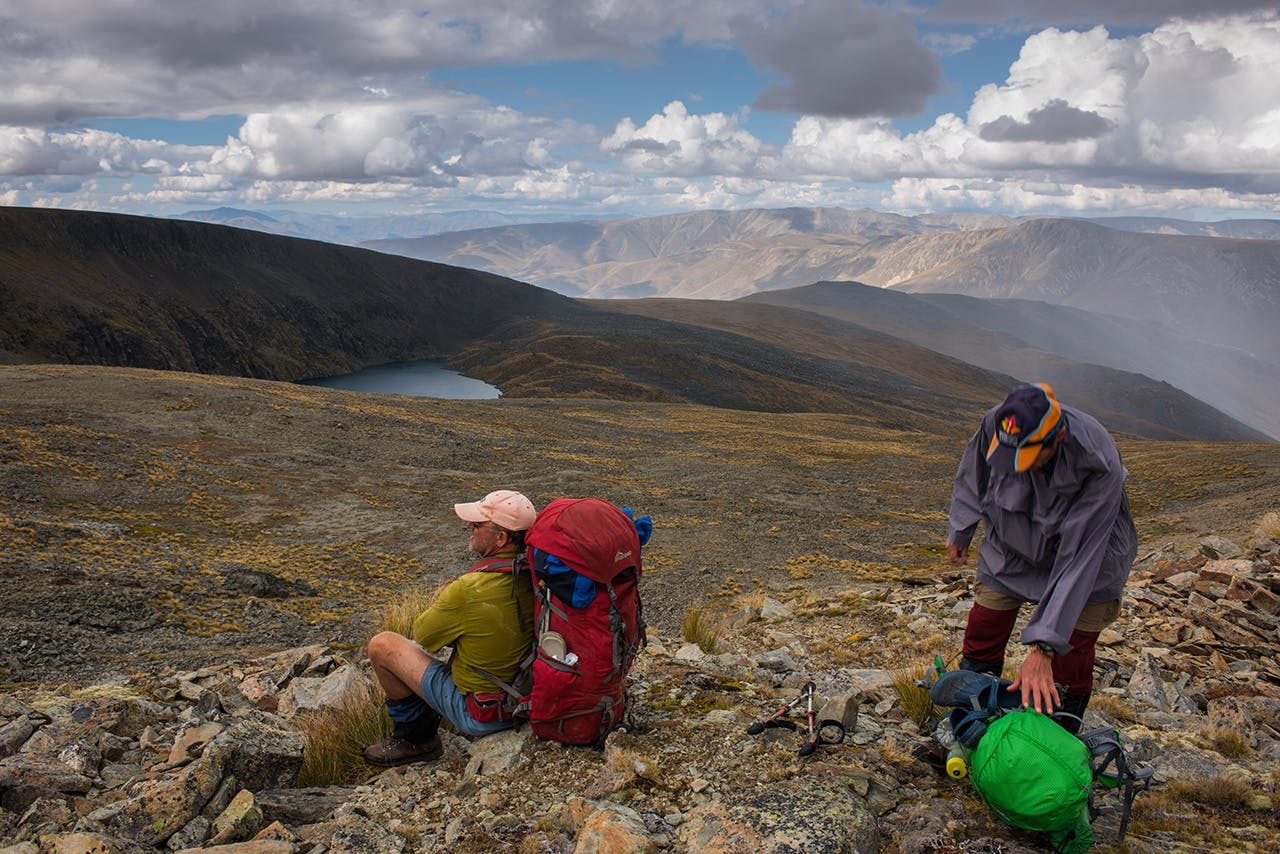
Around midday, we took a turn to the west and dropped precipitously off the high top into the head of Johnstons Creek, a tributary of the Manuherikia River East Branch. I picked it for a fast and easy descent to the valley floor, but it was nothing of the kind. Extra steep, loose, riddled with Spaniard grass, large hidden rocks under the tussock, and a jarring, slip-sliding descent, it took over two hours to reach easy going and a late lunch break in the valley. Looking back, I ruefully noted that the next spur along looked considerably easier and would have deposited us in the same spot without so much hardship.
We made quicker progress following Berwen Track, a 4WD trail, to the East Manuherikia and a suggested impromptu camp beside an old musterer’s hut. That was our plan, but en-route we met a large mob of sheep and later the runholder in his Landcruiser. Assuming we were heading to Boundary Hut in the next catchment, he offered us the full use of his new musterer’s hut, which we had passed just five minutes ago.
“Just clean it up for me, and do the dishes will you boys,” he said. “And by the way, there’s extra food in the locker, milk on the table, and beer under the bunk. Help yourself.”
He was gone quick smart and so we settled in by cracking open a Speights – what else? – to celebrate our good fortune.
We took the Mutton Creek Track, which connects the east west branches of the Manuherikia. It was a relatively easy trip, gaining 300m before descending again, and we marched it out in just two-and-a-half hours. Low cloud and drizzle clung to the ridge tops and a cool southerly wafted along the valleys on the descent. The west branch was considerably more attractive than the east and had a hinterland-feel. It also boasted two shelters – Boundary Creek Hut and Top Hut. We headed for the former and spent a long afternoon enjoying the tussock-filled valley and planning our next day’s climb onto the St Bathans Range.
The landscape around the hut was sublime, with high, rounded tussock-covered spurs rising from the valley floor into the far distance of the headwater creeks. I could not wait to get up there.
Climbs in Oteake are long and arduous. Ours was 1300m of ascent and over 11km of high ridgeline to cover to reach the St Bathans at 2100m, followed by an equally long traverse north to gain our campsite at Hidden Lake.
Invariably, big days mean an early start. Pre-dawn found us with headlamps on and following the 4WD trail high onto the ridge north of Boundary Creek – where it provides a steady incline for the ascent.
As we climbed, with the dawn glowing behind us, the view expanded to eventually cover the entire Oteake Conservation Park, much of the MacKenzie Basin with Aoraki/Mt Cook resplendent and, later, we clambered onto the St Bathans Range, the Lindis, Ahuriri, and Hawea regions.
Preparing for the descent to Hidden Lake. Photo: Pat Barett
Though I would normally eschew a route that lies mostly on a 4WD trail, the magnitude of the country, its unique position and sweeping panoramas, were just too dramatic to ignore. A pancake-flat section of ridge top at 1792m running for 1.6km surprised us – it was like a wide valley flat thrust up and placed on top of the ridge, and above this in a broad saddle beyond Pt1900m, was a wetland and streamlet in a small saddle at 1800m. Oteake is full of the unexpected.
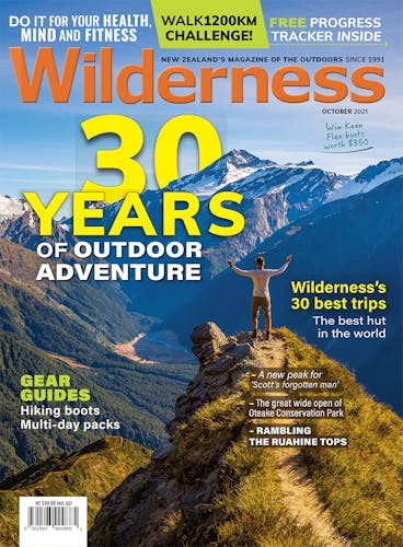
Near the crest of the St Bathans Range, the spur narrowed and climbed over a sub-summit of loose blocks to finally top out at 2098m. What a view! Immense doesn’t even come close: the scale, distance and depth of vision from here into the park and the adjoining regions is so big as to be almost incomprehensible. We ate lunch slowly, savouring the views, then headed on as clouds began to gather around the high peaks. There was still 10km of ridgetop plodding to go to reach the lake.
The afternoon wore on and the clouds continued to thicken and darken around us. We were at 1800m and had walked almost seven clicks since lunch. The walking was easy but there was another infuriating fence, running off into the distance for as far as we could see. Trudging on, we lurched into a saddle where salvation was at hand – an interesting diversion from the interminable tabletop range to reach Hidden Lake via a steep traverse around the mountain into the lake cirque. It was a blessed relief to leave the ridge and travel on our own, cutting across a face and descending into the basin, a deep cirque, looking much like a crater from a distance.
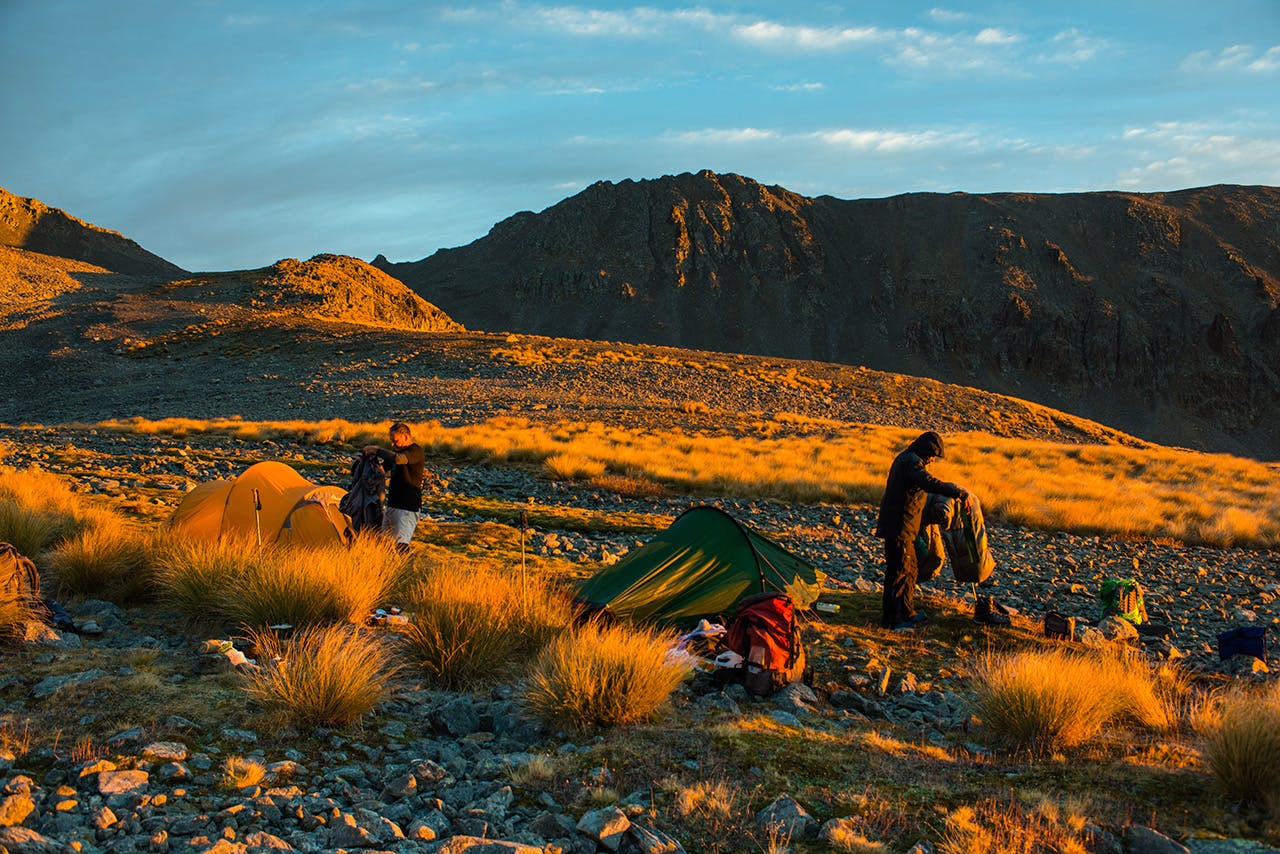
Bordered by cliffs to the north and a moraine dam to the south and east, Hidden Lake is large, deep and still. We had just pitched our tents when seemingly out of nowhere a swirling rainstorm cleared the range and descended into the basin, unleashing a torrent of water. We scurried inside our tents but within 15 minutes, the clouds rolled back and large blue rents appeared above the St Bathans Range. Down valley though, the heavy showers persisted until nightfall. Our camp turned out to be in a stunning location, with warm afternoon light filling the basin and washing over the tussock faces around us. A slight breeze and a sombre, brooding lake at our backdoor. We could see the complete route of the past few days and where we needed to go tomorrow, so it was a special place to reflect on the journey and enjoy the landscape.
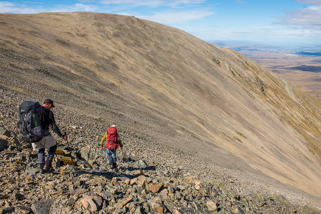
The loose, steep descent to Johnstons Creek. photo: Pat Barrett
The wind got up during the night, a nor’wester that was predicted to bring heavy rain to the divide but only moderate gales where we were. We were up and packed early, ready to go, and exited the basin over the moraine dam to reach the long gentle ridge that descends to Omarama Saddle.
We took a brief rest there, in the strengthening wind, before the last climb of the trip along Saddle Ridge Track, climbing 500m to an 1800m summit and then another undulating descent over easy terrain to our ute parked at Little Omarama Saddle.
We’d been over the tops of two ranges, through oases of beauty and valleys of golden tussock – the mountain desert – high and bleak, yet littered with gems.
