


A compact park featuring high mountains, massive glaciers, lakes, huts and a wonderful night sky
Driving SH8 between Tekapo and Twizel on a clear day, a panorama of ice-capped mountains unfolds as you round the bend above Lake Pukaki. Sun-baked grasslands give way to an impossibly azure lake crowned with a jagged horizon: the Southern Alps.
If you take a right turn, just after the control gates at the toe of the lake, you’ll be on a road that delivers some of New Zealand’s most iconic views – none less than Aoraki, the ‘Cloud Piercer’, straight ahead. Driving this road is in some ways a quintessential New Zealand experience; the drive passes alongside classic high country station runs and a landscape hewn by glaciers.
At the end of the road lies Mt Cook Village – a gateway to not only a huge variety of mountaineering, but also to some surprisingly accessible mountain experiences. The Hooker Valley Track is a world class alpine walk and like the Red Tarn Track, is perfect for a weekend wander, while the more adventurous can view the Caroline Face of Aoraki/Mt Cook and Ball Glacier up close, or tramp to the oldest hut in the national park.
Visit New Zealand’s longest glacier
The road leading to Mt Cook National Park parallels Lake Pukaki. This body of impossibly turquoise water fills a trench left behind by a glacier that once spanned the entire valley and extended into the Mackenzie Basin. Its legacy is carved into nearby mountain slopes, and telltale terraces high on the valley’s sides give a hint of its extent. This great glacier’s terminal moraines can be explored at the toe of Lake Pukaki.
Further up this same valley, the 27km-long Tasman Glacier still flows, fed by high névés tucked out of sight. Declining, like all of New Zealand’s glaciers, the lower reaches of the Tasman are not the ‘white ice’ that visitors might expect: here the glacier is covered with a burden of shattered rock and caravan-sized boulders. At the time of the first European visitors to this area, the glacier was more than 100m thicker and the terminal lake did not exist.
A 15-minute walk from the Blue Lakes and Tasman Glacier View car park provides a view like no other in New Zealand: the moraine-bearing glacier terminates at a wide vertical ice cliff that rises from a large lake. This ice cliff calves regularly into the lake. If your trip coincides with numerous icebergs, another good viewing spot is where they cluster at the lake outlet – the source of the Tasman River.
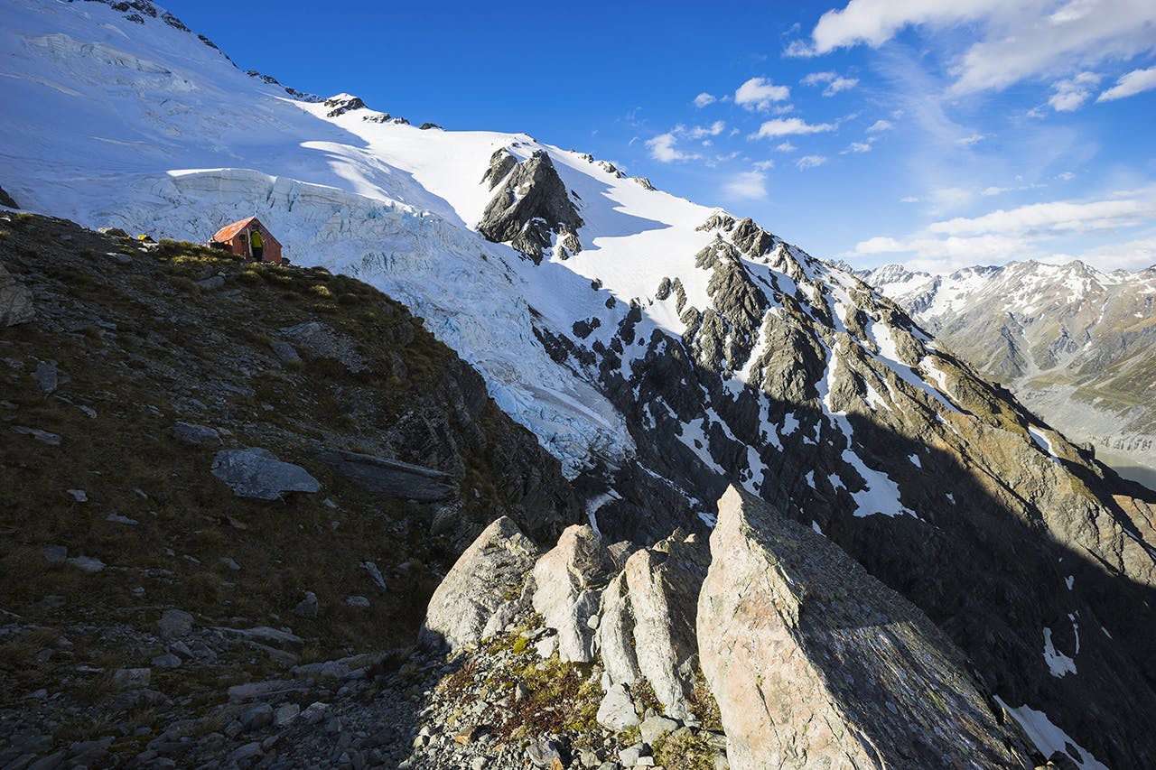
Spend a night in one of New Zealand’s highest huts
Plateau Hut makes for a special location to experience the high mountain environment. Photo: Mark Watson
A more singular location than Aoraki/Mt Cook’s Grand Plateau is hard to find. This great mountain shelf divides the Mt Cook Range and Main Divide in two, separating the permanently ice-capped upper reaches of Aoraki, Mt Tasman and nearby peaks from the broken rock ridges and moraine-strewn walls below. These slopes – particularly Haast Ridge – were traditional access routes for the technical climbing that lay above. These days, access to Grand Plateau is most commonly by helicopter, although some climbers still walk out (and sometimes in) via Cinerama Col.
The icefields of the Grand Plateau drain into the Hochstetter Icefall, a steep flow of towering ice and massive crevasses. The Hochstetter in turn flows to the Tasman Glacier. It was down this channel that the debris from Aoraki’s famous 1991 summit collapse flowed – smothering the icefall – before crossing the entire width of the lower Tasman Glacier.
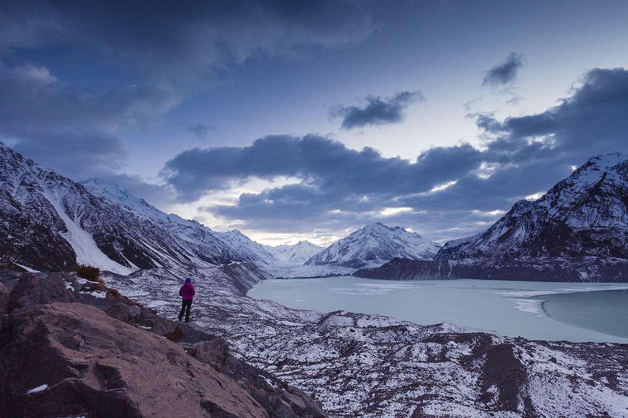
The 33-bunk Plateau Hut is bolted to a rock outcrop on the edge of the plateau. Cantilevered into space, the hut seems to hang over the Hochstetter and makes a very special location for enjoying the light, sights and sounds of the high mountain environment. Ice avalanches from the many active ice cliffs that hang from the mountain faces are a common sight.
Without glacier travel experience, there is limited opportunity to explore Plateau Hut’s surrounds, however, in all but late summer conditions, you can helicopter practically to the door.
Gaze upon New Zealand’s tallest mountain face
Although this spectacular location can be reached in just a few hours from the road end, its panoramic position makes you feel just a stone’s throw from the icy slopes of Aoraki/Mt Cook itself, and has you surrounded by New Zealand’s highest ranges.
The Caroline Face was the last major face on the mountain to be climbed and was a sought after prize until its 1970 ascent by Peter Gough and John Glasgow. These days, glacial recession and the quest for more technical climbing has seen the face fall out of fashion, but it is no less impressive when viewed from Ball Ridge.
Ball Ridge can be accessed as part of a Ball Pass crossing, or as a destination for a day or overnight trip. It is most easily reached from the parking area for the Tasman Glacier View on Ball Road. It’s 8km up the road and track to Ball Hut, on the moraine terrace above the vast rocky stretch of the Tasman Glacier. During the 1960s and 70s a much larger Ball Hut – the nerve centre of the New Zealand mountaineering scene – served this site until it was destroyed by fire.
From the terrace, Ball Ridge can be accessed via a light ground trail. While views are possible as soon as the ridge is reached, tramping to the point where the ridge flattens out at 1760m offers the most stunning views and makes a good campsite. Looking at the broken crevasses of the Ball Glacier far below, it’s hard to believe that in 1933 this was the site of New Zealand’s first Skiing Championships. But look up, and perhaps you can imagine climbers deftly picking their way up this giant face.
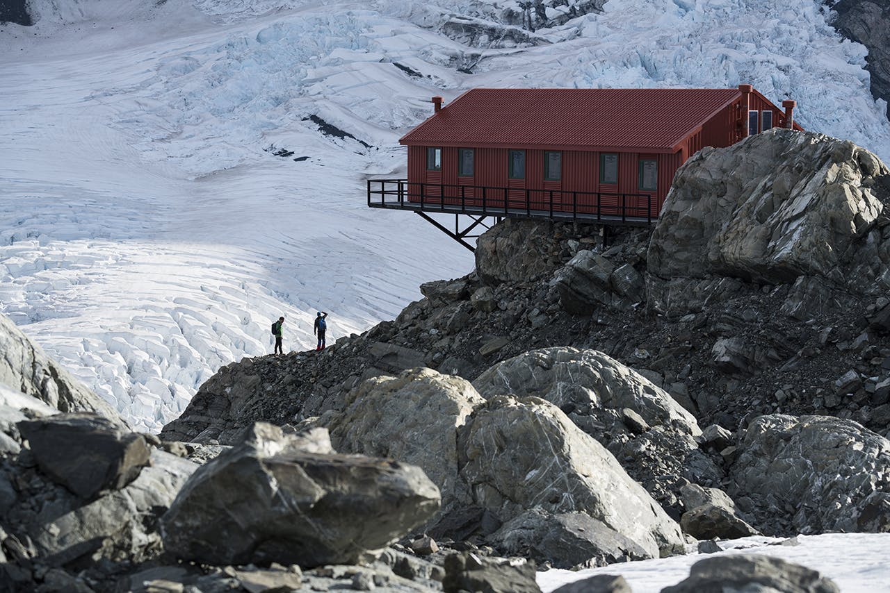
View the night sky from above Mt Cook Village
The track to Red Tarns provides excellent views of the village below and the night sky above. Photo: Mark Watson
One of the most accessible highpoints above Mt Cook Village is reached on the Red Tarn Track. While the Red Tarns themselves are home to some unique alpine plants – particularly the low-lying sticky insect-catching drosera – they are fairly unremarkable. The view from here on a clear day though is well worth the 30-45 minute walk.
From the village, a formed trail climbs through beech forest and mixed alpine scrubland to a viewpoint and seat at the edge of the Red Tarn Terrace. A little further back, a plane table and seat sit at a slightly more sheltered spot.
This site takes in excellent views of the Sealy Range, Mt Sefton, Aoraki/Mt Cook and Mt Wakefield.
You might be lucky and encounter kea here.
The track is easy to descend in the dark (bring a torch) so makes a good site to watch the progression of sunset, through the alpenglow (the beautiful diffused mountain light present after sunset) and into darkness and starlight.
Gain an eagle’s eye view of the park
Sefton Bivouac is the oldest hut in the park and provides excellent views. Photo: Mark Watson
Sat like an eagle’s eyrie at the top of a narrow rock spur, Sefton Bivouac is a fantastic spot for views into the Hooker Valley, Lower Tasman and Mueller Glacier. The Footstool and the 2000m East Face of Mt Sefton form a backdrop to this spectacularly sited hut.
Sefton Bivouac is the oldest hut in the park and has been a resting point for climbers since the early 1900s.
A tramp to the bivouac is not for the faint of heart; the route is exposed and steep in places and it is only lightly marked. However, the ground trail is well trodden by generations of visitors, and is easy to follow. Depending on snow cover, an ice axe and crampons might be required for the final slopes approaching the bivouac. Check with DOC on current conditions and access details.
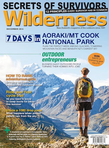
Those making the steep trek to the bivouac will be rewarded with an amazing view over the ever-growing Mueller Glacier terminal lake. During the early 1900s, this lake was a bridge of easily crossed glacial ice – over 100m higher – that was used to drive sheep to the lower Hooker Valley for grazing.
The canyon-like lower reaches of the glacier, below Sefton’s East Face, are a great sight. Fine views of Mueller Hut, the Sealy Range and Mt Wakefield make this a location well worth the walk for confident trampers.
Wander up New Zealand’s most famous alpine valley
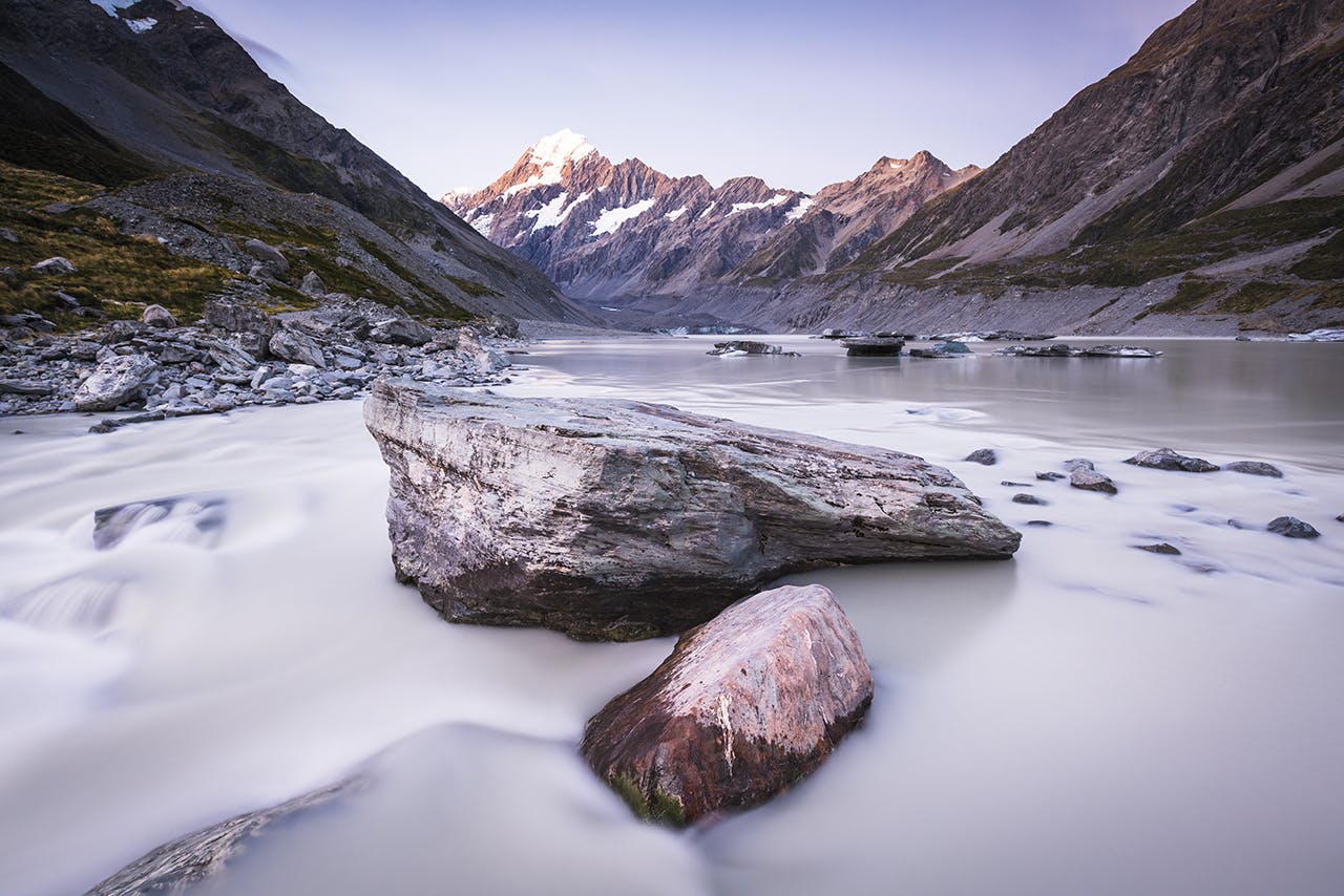
The Hooker Track leads trampers to this remarkable scene of New Zealand’s highest mountain. Photo: Mark Watson
There is no more accessible location for high mountain immersion than Hooker Valley.
At the icy head of the valley, just out of sight, great ranges separate: the Main Divide kinks west at Mt Dampier before curving south, while the Mt Cook Range (and Aoraki’s summit) is a southerly jutting outlier, between the two lies the Hooker Glacier, fed by the icefalls and névés which drape these peaks.
The terminal lake at the toe of the Hooker Glacier can be reached in a three-hour (return) walk from the White Horse Hill car park. This is an easy wander along a well-formed track, taking in three bridged crossings of the Hooker River, each with its own spectacular views. During spring and early summer, it will be a walk through blooming alpine plants, notably the Mount Cook buttercup as well as daisies and spaniards, while a winter wander brings a different flavour to the valley, with iced boulders, frosted snow tussock and sometimes a freeze on the Hooker Lake.
To walk up this valley is to witness change wrought on the landscape by glacial advance and recession, and the weathering impact of high rainfall. You’ll cross old terminal moraines, see ice falls and massive scree slopes but most notably, witness a lake that has existed in the valley since only the early 1980s.
