


- Notes & Map
- Adams Wilderness Area (pdf, 8 MB)
The Adams Wilderness Area straddles the Main Divide of the central Southern Alps. It’s a place of dense rainforests, fearsome gorges, high glaciated plateaus and some of the country’s most formidable mountains.
I always think of the Adams Wilderness Area as John Pascoe country. During the 1930s, the Canterbury mountaineer made his name by leading expeditions to the area and ascending some of its most testing peaks. In 1934, he, Gavin Malcolmson and Priestley Thomson claimed the first ascent of Mt Evans, then the highest unclimbed peak in the Southern Alps.
Pascoe and his companions also bestowed the names ‘Garden of Eden’ and ‘Garden of Allah’ on the two most significant ice plateaus, and the biblical theme continued with other names like the Devils Backbone, Satan Saddle, Eves Rib and Beelzebub Glacier. In turn, the ridge separating the two ice plateaus was later named after Pascoe. In his book Great days in New Zealand mountaineering, Pascoe wrote: ‘In wrestling with the obstacles met by the early explorers, the parties of today can experience some of their trials. This understanding brings the benefit of humility. If some wilderness areas are left for future generations they will be able to share this knowledge.’
Federated Mountain Clubs proposed a wilderness area for the Adams after its landmark 1981 conference, but it wasn’t until more than 20 years later, after DOC reignited the flame, that the Adams Wilderness Area was finally gazetted in 2003.
Westland’s Perth, Whitcombe and Wanganui rivers, all of which provide access routes, bound the 46,600ha wilderness. From the Canterbury side, the Rakaia and Rangitata Rivers offer the most direct access.
In February 2008, Geoff Spearpoint and Phil Novis completed an astonishing dash over the entire width of the wilderness area in a single 24-hour period, crossing both the Gardens in one push. Pascoe would have been gobsmacked – and impressed.
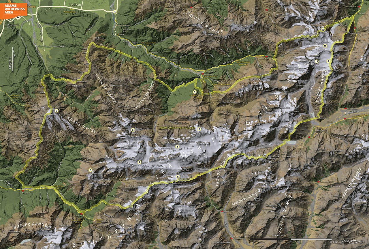
1. Lambert Spur and tops
Access to the wilderness area is possible via the Wanganui River track, Hunters Hut, and the Lambert Tops Route. The marked route ascends a spur commonly known as Lambert Spur, between the Adams and Lambert Rivers (the latter tantalisingly marked on the map with ‘impossible gorge’). The track emerges onto wonderful, open tussock tops, with plenty of tarns. From here, it’s possible to reach the Garden of Allah via a difficult and circuitous route on the north-eastern flanks of Mt Lambert.
2. Mt Lambert
This significant peak (2430m) stands sentinel over the Gardens; a high glacier-strewn mountain guarded by steep approaches.
3. Garden of Allah
The Garden of Allah straddles two branches of the Wanganui catchment; the Adams and Lambert, and seeds glaciers into both valleys. It provides access to the Garden of Eden by way of Adams Col or the slopes of Mt Tyndall.
4. Garden of Eden Ice Plateau
What tramper isn’t mesmerised by this aptly chosen Pascoe name? Don’t be fooled though; this is no tropical paradise; instead it’s a garden of ice – vast and glittering; a magnet for trans-alpine adventurers. Tributary glaciers flow from it into the Perth, Adams and Barlow.
5. Perth Col
Perth Col provides the usual route onto the Garden of Eden from the Canterbury side. After a long slog up the Clyde and the Frances rivers, a route leads up the Colin Campbell Glacier, then Wee McGregor Glacier, to finally reach Perth Col. From the saddle, an easy sidle leads beneath Baker Peak onto the Garden of Eden Ice Plateau.
6. Mt Kensington
The isolated Mt Kensington (2444m) spawns the Arethusa Icefall, from which relatively moderate slopes lead to the summit. North, however, the peak drops away abruptly into horrendous bluffs. It’s climbed very rarely.
7. Mt Adams
Although exposed, and high, Mt Adams (2208m) is probably the most accessible and approachable of all the significant peaks of the Adams Wilderness Area. It lords over a huge chunk of exceptionally difficult, forested catchments in the Poerua, Wilberg and Barlow, which form the western block of the wilderness. The peak itself is reached on a relatively easy trampers’ route up Dry Creek that begins from SH6 near Whataroa.
8. The Great Unknown
The Great Unknown (2196m) is a high outlier in the south-west of the Adams Wilderness Area. It’s sometimes traversed as a route off the Gardens into the Perth Valley, but it’s a traverse that demands respect.
9. Bracken Snowfield and Sale Glacier
As if all the terrain of the Gardens wasn’t enough for the mountaineer or trans-alpine tramper, the north-eastern part of the wilderness offers more wondrous trips. Large glaciers spill from the flanks of Mt Evans and Whitcombe, making alluring routes for those travelling between the headwaters of Canterbury’s Rakaia and Westland’s Wanganui Valley. The easiest way to access the Bracken Snowfield is by way of the Whitcombe Pass and Sale Glacier, beneath Lauper Peak.
10. Mt Evans
Mt Evans (2620m) is an impressive mountain, no matter where you view it from – although perhaps no more so than from Cave Camp in the Whitcombe Valley, where the mountains fall in a great series of hanging glaciers and black bluffs, laced with waterfalls. It was from this side that Pascoe’s party first ascended the mountain.
11. Mt Whitcombe
Mt Whitcombe (2650m) tops Evans by 30m, and is no less impressive for its remoteness, difficulty of access and formidable faces. Indeed, the Ramsay Face of the mountain is considered one of the great faces of the Southern Alps, and is very rarely climbed. Those who ascend the mountain usually do so by way of the Bracken Snowfield and Snow Dome. Trampers without alpine skills can get a great view of the Ramsay Face from Meins Knob, lying a short distance south-east of the wilderness area.
Download the Adams Wilderness Area map.
