


A trip to the West Coast’s Stafford Hut and Carmichael Plateau is a journey through time and untamed wilderness.
The West Coast has a strange power of attraction. Its wild coast, untamed rivers and dominating rainforests have attracted curious and determined visitors since Aotearoa was first settled. Māori visited the coast from at least the 1300s to gather pounamu, mainly from the waters of the Arahura River. By the 1840s, pākehā explorers such as Charles Heaphy and Thomas Brunner were venturing there searching for land to open up for farming. Yet, in spite of the draw the region has on people, it wasn’t until 1960 that the road linking Haast and Wānaka was finally completed.
As with many before me, it was curiosity that drew me to the Coast, especially to the area south of Jackson Bay, near Haast.
Our plan was to tramp to Stafford Bay before continuing down the coast and looping back through Teer Creek and the Carmichael Plateau. With the sun shining, we headed into the dense forest.
The first part of the route to Stafford Hut was easy going as we followed an old pack track beside Saddle Creek. This track was constructed in the 1870s to supply a short-lived settlement of German Poles who had taken up 20ha blocks of land near the mouth of the Smoothwater River. The settlement didn’t last long and it wasn’t hard to see why; the valley that the Smoothwater River runs through is heavily forested and isolated, even from the nearest settlement of Jackson Bay.
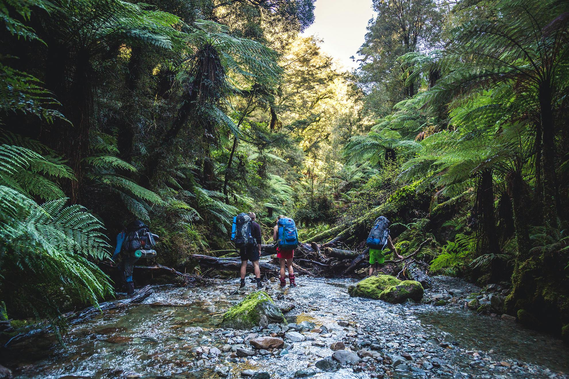
The pack track ends at the river, where a right-branching trail leads to Smoothwater Bay. A sign for the inland track to Stafford Hut seemingly points straight into the river and soon we were splashing our way through the Smoothwater, pleased it was living up to its name. One of our party commented that the last time he had visited, the water had been up to his chest in parts.
Half a kilometre from the junction, we rejoined a marked track on the other side of Kakapo Stream, a tributary of the Smoothwater. The track crisscrossed the stream, gradually making its way towards Stafford Saddle. Without much warning, it suddenly launched us into a spirited ascent of 150 vertical metres to the saddle. The far side of the saddle was equally steep and it took some good spacing (social-distancing in the post-COVID world) to avoid becoming a human domino line.
At the bottom, we were spat out unceremoniously at the confluence of two small streams and a marked route led us down the creek, over slippery rocks and fallen trees. The creek eventually joins the Stafford River at a wide flood plain.
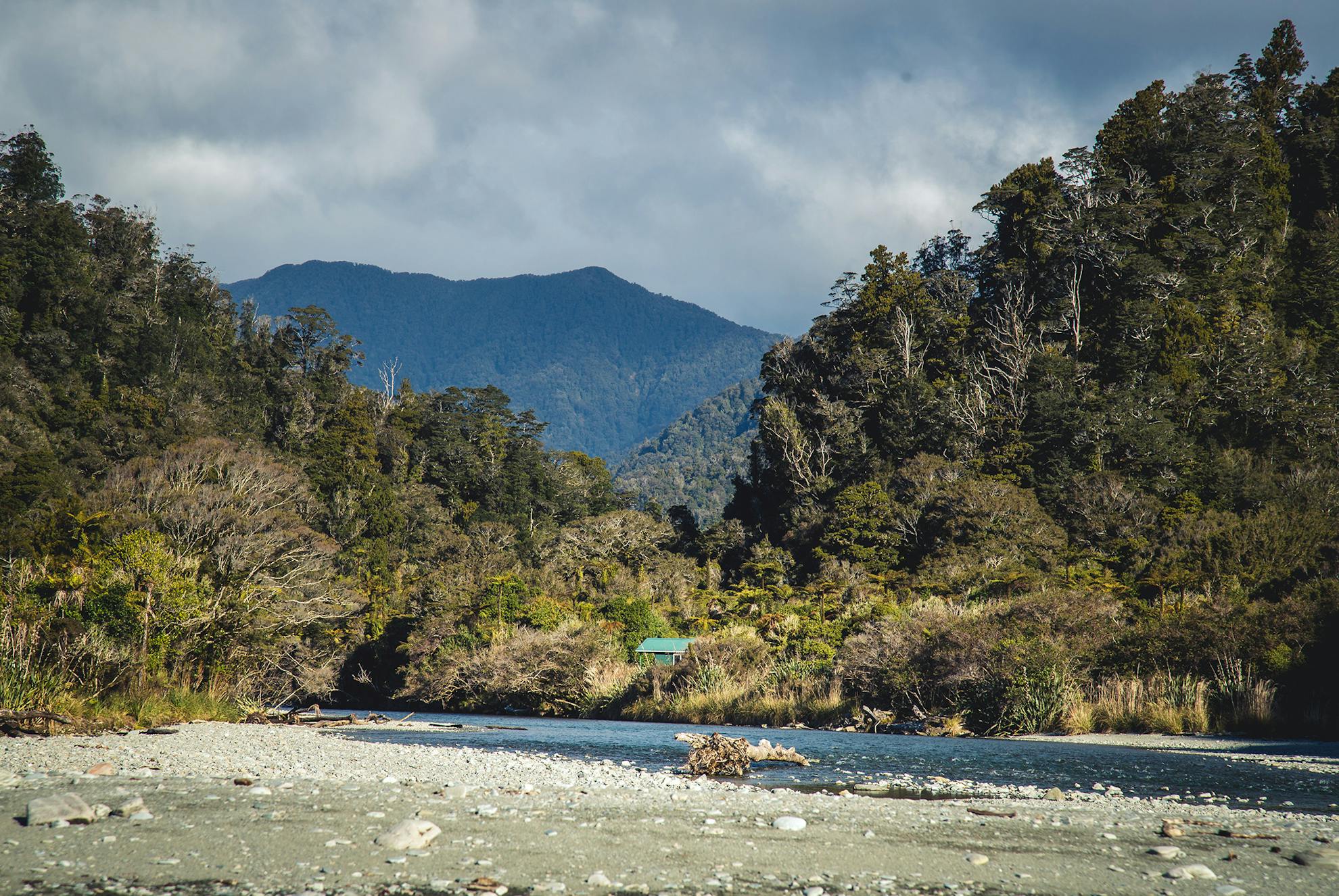
When we left the bush, there was a heavy salty smell accompanied by the sound of the heaving sea. However, we needed to cross the Stafford River again and re-enter the bush for a short distance before reaching the handsome Stafford Hut, a six-bunker situated 100m from the bay.
There are rocky headlands at each end of Stafford Bay, impassable except at low tide or when the sea is calm. Waves crashed spectacularly against the rocks. It was a shame the tide was high as we knew the area has good rock pools for gathering kaimoana.
That night, we cooked a calzone pizza on a homemade pizza pan propped up by empty beer cans in the stove.
The next day, we had to wait for the tide to retreat before carefully making our way around the headland. From then on, the coast was relatively easy-going and we made good time past Stafford Rocks. Castaway fishing buoys would occasionally catch our eye. At one bouy, we startled a Fiordland crested penguin that let its displeasure at our intrusion be known. Further along the coast, we stopped for lunch at Seal Rock, which we shared at a distance with a number of blubbery friends.
Further down the coast, we could see Cascade Plateau jutting aggressively into the Tasman Sea, just past the mouth of Teer Creek. We passed a towering island of rock topped by a few trees, standing lonely against the breaking waves.
We reached Teer Creek in the early afternoon. At its mouth, there was a nice flat area suitable for pitching tents but our plans didn’t allow us to stop here, so we pressed on upstream and into the unknown.
The creek was a collection of emerald green pools and dazzling white water. Upriver progress was slower than we’d hoped, with giant boulders and deep pools. We reached a broad bend in the river and pitched our tents.
With a couple of hours of daylight left, three of us climbed 200m to the northern-most edge of Cascade Plateau. Our steep bush bash was rewarded with spectacular golden hour views across the plateau and to the Tasman Sea.
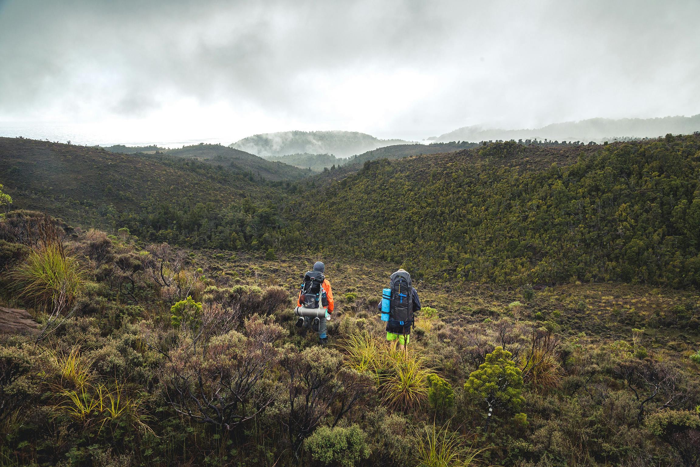
We split into two groups the next day, with two of us retracing the coastal route and three opting to climb north out of Teer Creek to tramp across Carmichael Plateau and then traverse McArthur Tops to reach Stafford Hut.
Before leaving Stafford Hut the previous day, we had noticed the red scar of a landslip that ran to a swampy flat above the river. Those of us crossing the Carmichael Plateau set our sights on this, guessing it would be easier than pushing our way through the dense bush.
At the Carmichael Plateau, the weather worsened but crossing these tussock tops was simple and before long we were skipping across the various tributaries of Carmichael Creek.
As the afternoon wore on, we negotiated the last tributary of the creek, through steep terrain, and made our way up a spur to the north of Pt500 to gain McArthur Tops. There were faint traces of a trail near the ridge, although, as Stafford Hut owes its existence to large-scale deer control in the 1970s, this was most likely made by deer. With the hut as a base, deer were shot, stored in a freezer and helicoptered out.
A perplexing sight confronted us on the far side of the ridge: nothing. The hill seemed to end suddenly in a basin of mist and low hanging cloud. As we got closer, it became clear we were atop a colossal slip that stretched hundreds of metres to the Stafford River.
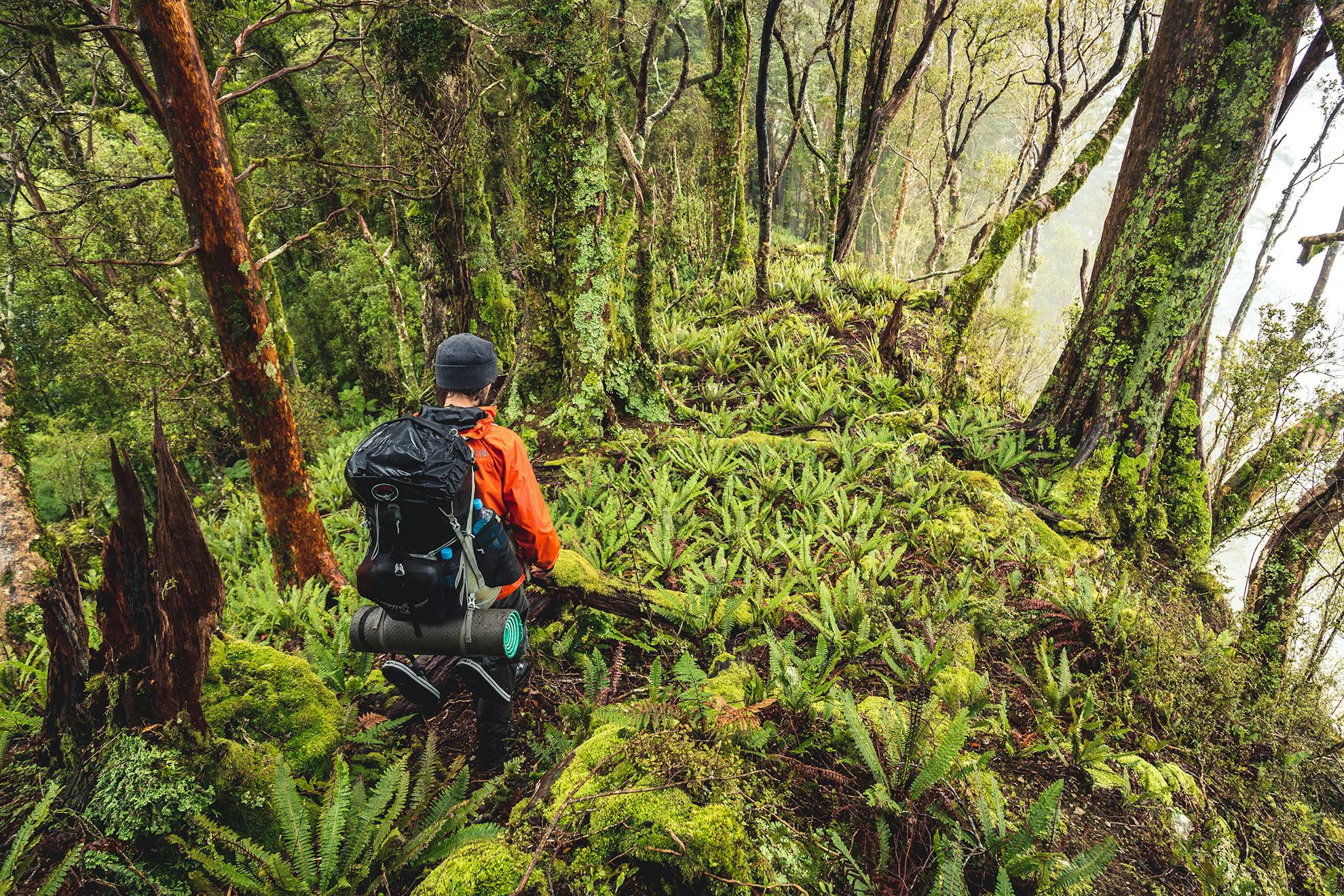
The McArthur ridge was interesting; some stretches were a breeze, other sections put up more of a fight. Interspersed along the way was the occasional marker, perhaps the remnants of deer culling activities. Navigation was awkward, with a maze of ridges shooting off in multiple directions at times accompanied by tall fern and monkey scrub. As we neared the hut, we began dropping off the range on a spur through rough country, at times needing both hands and feet. Soon, smoke could be smelled wafting through the canopy, suggesting the hut was near and our friends had reached it first
During the night, rain pounded the hut and we were worried the river would come up. In the morning, a fresh shower was beginning, soon accompanied by ominous booms of thunder. This intensified into a full-blown thunderstorm. Fortunately, the river didn’t rise too much and we made it back over the hill to Jackson Bay.
As the trip came to an end, we felt Stafford Hut had left a big impression for such a small place. The surrounding countryside harbours curious geological features and stories of human endeavour. Our journey was another addition to a long tradition of adventure-seeking along the length of that untamed shore.
- Distance
- 33km
- Total Ascent
- 1932m
- Grade
- Difficult
- Time
- Four days. To Stafford Hut, 3-4hr; To Teer Creek campsite, 6-7hr; To Stafford Hut via Caarmichael Plateau, 8-9hr
- Accom.
- Stafford Hut ($5, six bunks).
- Access
- Haast Jackson Bay Road
- Map
- BY10, BZ10
GPX File
- Carmichael Plateau (gpx, 27 KB)
GPX File
- Your device does not support GPX files. Please try a different device.
