


A long weekend trip in Arthur’s Pass National Park that includes four-bunk bivvies, tarns and open tops.
Wild Westland on a fine day, or two or three, is just too hard to pass up. It was just such fine weather that tempted three of us over the divide one fine weekend to sample an array of the treats that only the west can offer to keen trampers. Treats like magnificent valley scenery, lush bush, high huts, and open trackless tops where the mind and body can wander at will, seeking routes between the ridges.
The Taramakau River was our entry point, at Aickens just north of Otira. The river offers a broad easy avenue of bouldery riverbed, interspersed with grassy river terraces and tongues of forest descending in an unbroken green wave from high steep ridge tops.
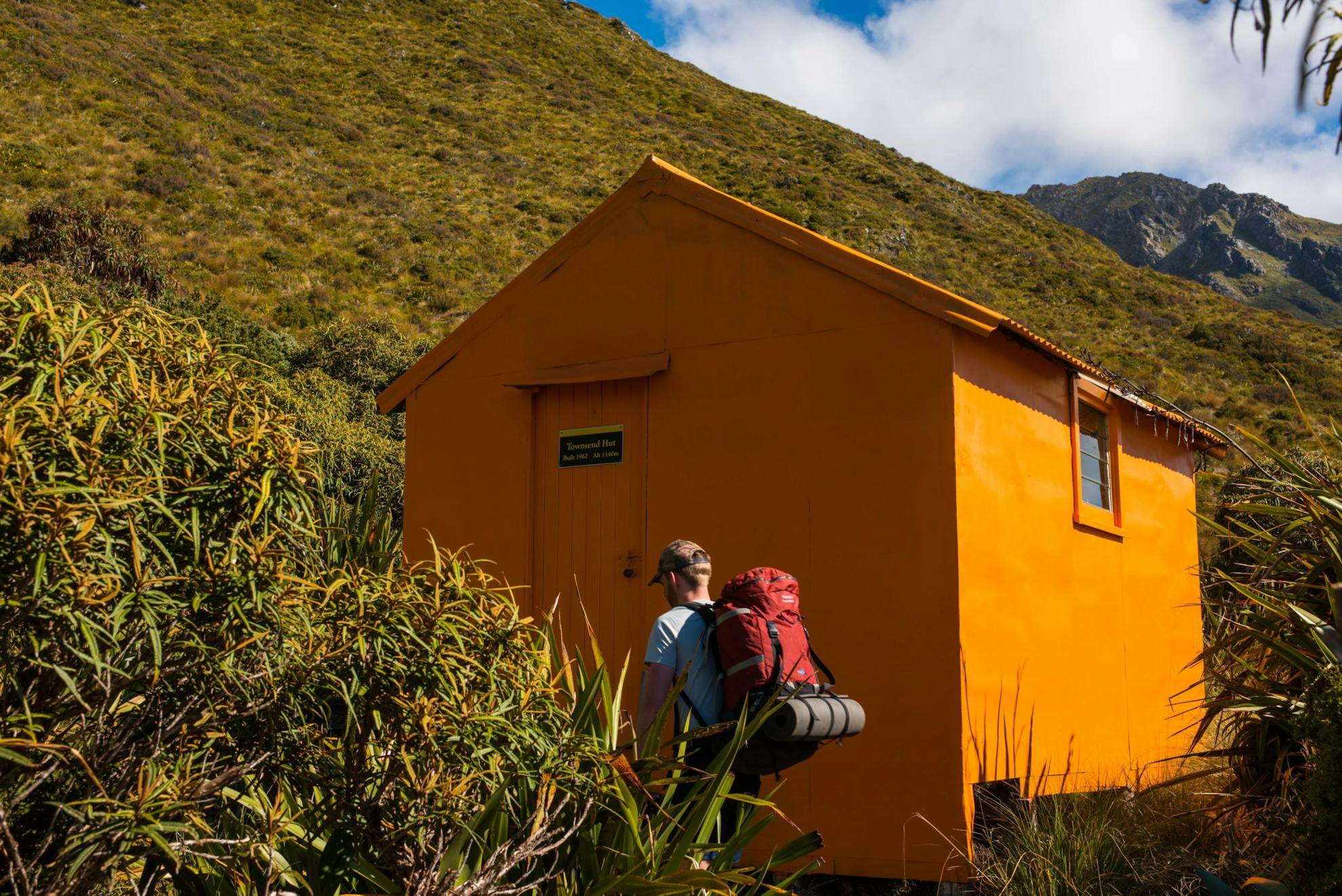
As the weather had been dry for a week or more prior to our visit, the rivers were predictably low, clear and easy to ford which was a bonus as the Otira and Otehake or Taramakau rivers must be forded to gain entry to the upper valley. Our route lay a few hours up-valley, where an ultra-steep track heads skywards to Townsend Hut, which sits on a fault scarp at around 1140m on the northern faces of Kā Tiritiri o te Moana – the Southern Alps.
First though was a pleasant valley wander as the sun slowly broke through a deep blanket of cloud to warm the trail and river terraces.
The terraces were easy fare for us, most cut with vehicle tracks leading to several private huts and one DOC hut – Kiwi Hut – baking in the midday sun by the time we arrived. Kiwi Hut, like most on the West Coast, is an ex-Forest Service hut offering standard accommodation, a pleasing panorama of bush and mountain from its louvre windows and fixed panes, and history aplenty contained in the hut book.
But tramping is forever onwards – to the hut, the camp, the tops, the peak; just onwards. The climb to Townsend is not extreme in terms of height gain, just 750m, but it is steep, and approaches 70-degrees or more on some pitches through the bush. Those pitches are sustained and dumped us on short steps followed by another steep pitch, and then another. Work hard, play hard as the saying goes. Though this ‘play hard’ was more like grip hard and climb hard or fall hard into the bush below.
“Bit of a grunt,” I puffed to Nick who was following close behind. “Yep,” was all he could manage in reply.
After some serious thoughts on how much we were not enjoying this tangle in the trees with a heavy load, we popped out into the sub-alpine zone and a short while later open tussock and the high bench where the hut lies. It was mid-afternoon and the prospect of a long rest at the hut before nightfall was very agreeable, particularly when the view on offer was stupendous.
From its 1140m vantage, Townsend’s northerly view encompasses all the Kaimata Range, crowned by the massive bulk of Mt Alexander (1958m), and the great trench of the Taramakau Valley fading in the afternoon haze away towards the Tasman Sea. Grand location, awesome scenery, good company, a hot afternoon at a cool hut – it was bliss.
Tea’s up, was the call for the afternoon, plus check the hut book, wander the little tracks at hut-side to overlook the valley depths, and take a nap on the bunk.
I spent time checking the next day’s route which was through some fairly steep country to the head of Koropuku Creek and its resident hut. It looked good, a few challenges maybe, but that was for tomorrow.
Just on dusk, a French tramper turned up. Jacques was planning to head into Minchin Stream and Poulter Valley the next day. We swapped notes before retiring, sharing dinner and the amazing sunset.
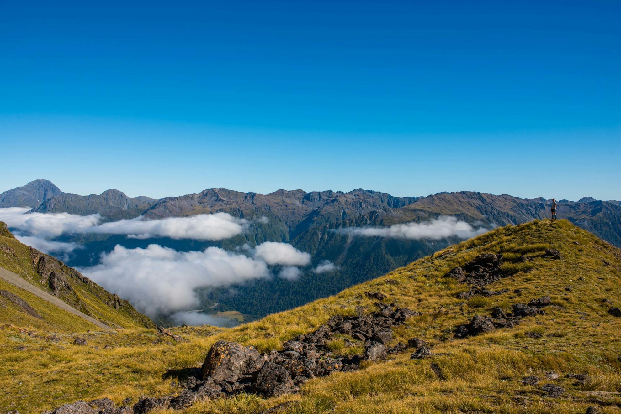
Though thick cloud had gathered round the hut the previous night, there was no sign of it come early morning as we headed off towards the first basin to the west, directly beneath Mt Koeti. Some wispy clumps of cloud hung suspended on sheltered ridges but soon the sun was out illuminating the tops and our progress through a bluff section between the first and second basins.
A short steep climb led to the narrow pass between Pt1681 and Pt1686, leading into Koropuku Creek at just over 1600m. We paused to rest and breathed in the amazing view into Arthur’s Pass National Park, before descending carefully through more bluffs and scarps into the basin below the pass.
This delightful spot was filled with alpine plants, gin-clear streamlets and was the perfect lunch stop. The day was a blue-sky wonder, and warm, so we made the most of an ample break before heading out of the basin and into a moderately tricky descent down a steep rib and bluffs. Later we threaded thick scrub to reach Koropuku Creek.
From this point, mostly easy walking with the occasional diversion through monkey scrub, led to the first streamside track marker indicating the short trail to Koropuku Hut.
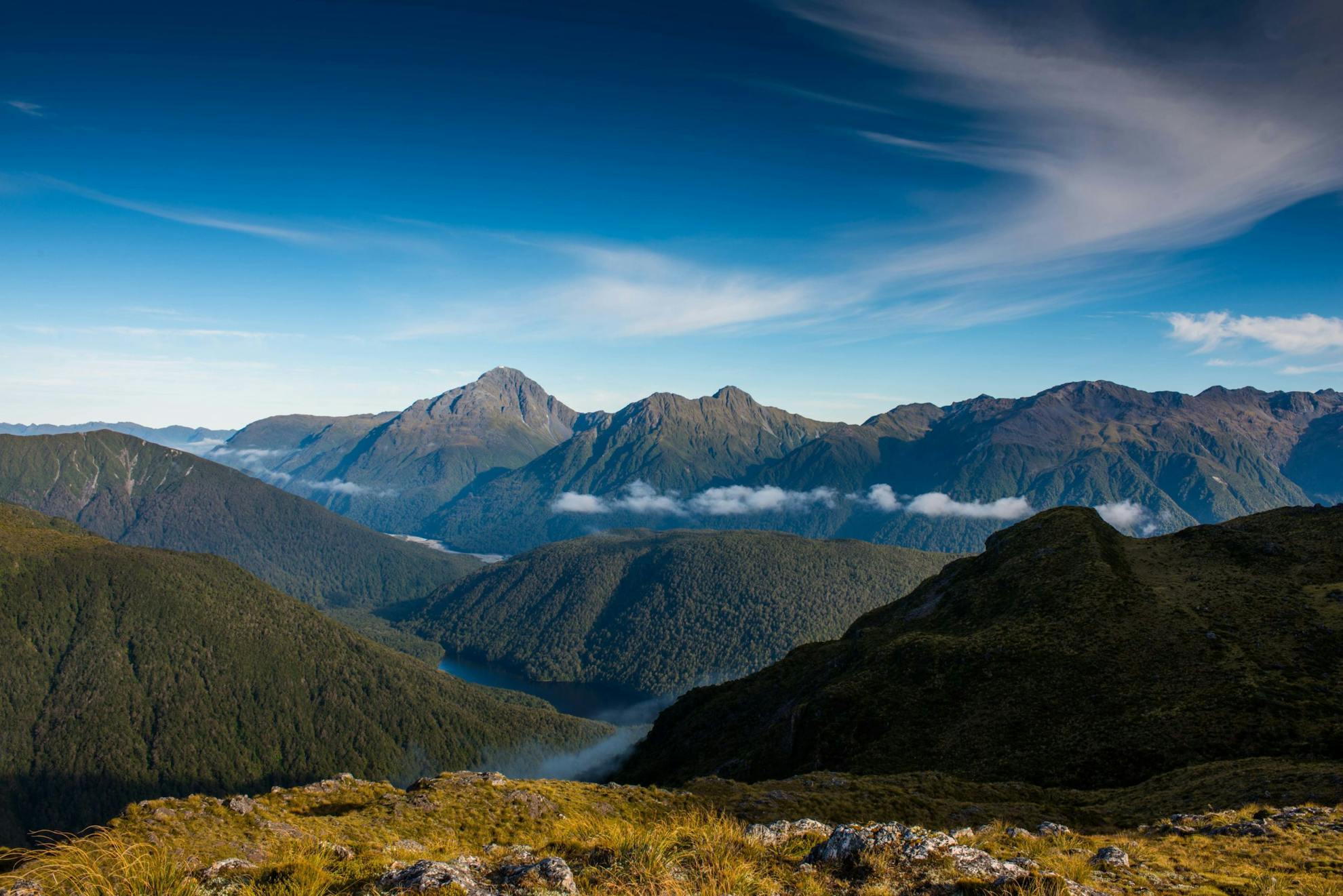
The hut was steaming in the mid-afternoon sun when we arrived. We threw open the windows, cleared gear from our packs and prepared for another long lazy afternoon admiring the great wall of mountains directly opposite. Koropuku has an incredible setting and is now a sought after destination as it sits just at the edge of the bush below the massive bluffed face of Mt McCrae, 1753m. It has superb views all the way up the Otehake River to Falling Mountain as well as up Koropuku Creek from where we’d come. It was the spot to relax and enjoy the accomplishment of the crossing from Townsend – and we made the most of it.
Just on dusk, another lone tramper turned up. Micheal had stashed his gear on one of the hut bunks while he was away climbing Mt McRae. He was a true loner and chose to camp down the track rather than spend another night at the hut.
With a long walk out to Aickens ahead of us, we left before dawn as stars glittered from the slash of sky above the creek.
Climbing out of Koropuku is not easy. There’s a track, but it climbs in and out of a 400m deep jagged defile that follows the line of a creek bed, complete with waterfalls which the track bypasses on several steep sections. It’s an unrelenting ascent, which gets even steeper near the top despite the map showing an easing gradient.
As we rose above the streambed scramble and into the tussock, the cloud melted away to leave a beautiful morning spectacle of high, eroded mountains and deep valleys filled with voluminous cloud banks. It was mesmerising.
We then topped out at a series of small tarns near Pt1259 which led us over two high shoulders to the track descending to the Otehake Valley.
Another spectacle awaited here; this time the seductive Lake Kaurapataka, hidden beneath the bushy hills and pushed up between the Otehake and Taramakau valleys, beyond which stood the great buttressed summit of Mt Alexander.
We had a long, tiring descent ahead – 800m to the valley floor – and then a ford of the Otehake and a brief climb to the large basin and Lake Kaurapataka.
We ate lunch on the shores of the lake, while Peter took a boots-and-all dip in the lake’s sultry depths. The still beauty and deep bush immersion of the setting around the lake is always a special part of trips into this section of the valley; that and the easy walking out from here. It’s down the red beech terraces of Pfeifer Creek to the Taramakau and its open flats and riverbed.
The car was not far off now, the trip was done, the memories banked, the scenery superb.
- Distance
- 31.9km
- Total Ascent
- 2090m
- Grade
- Moderate
- Time
- Three days. To Townsend Hut, 5-6hr; To Koropuku Hut, 6hr; To SH73, 8-10hr
- Accom.
- Townsend Hut (free, four bunks), Koropuku Hut (free, four bunks)
- Access
- Off SH73, 9.5km north of Otira at marked car park by the road. Take care with fording the Otira and never attempt after heavy rain.
- Map
- BU20, BU21, BV21
GPX File
- Townsend and Koropuku huts (gpx, 20 KB)
GPX File
- Your device does not support GPX files. Please try a different device.
