


Inspired by first-hand accounts of Fiordland’s early explorers, Tarsh Turner sets out to cross Marshall Pass, a journey that proved to be as rewarding as it was challenging.
I kicked my boots into the soft gravel slope and searched for a solid handhold, feeling acutely aware of the weight of my pack and the band of cliffs below. Above was a steep pinched gut, which looked climable, but I was battling with my nerves, as was my mate. I turned back to see his eyes wide. He didn’t look keen to follow me.
We were attempting to follow a route described in Moir’s Guide that hadn’t changed since my dog-eared 1986 copy was published. The intervening years had seen rockfall make things much more… interesting. We were climbing alongside Flower Fall, en route to Marshall Pass, in the hinterland of the Milford Track. As we kept reminding each other: this was just meant to be tramping.
I had learned of this route while reading about the Fiordland explorations of W. G. Grave, whose party was the first to cross and name Marshall Pass in January 1906. The original party of five men set out from the head of Lake Te Anau along the Milford Track in December 1905. Mackinnon Pass had only been discovered nine years earlier, and little was known about the surrounding valleys.
‘The rough nature of the ground, the heavy bush consisting of trees matted together with deep undergrowth and interlacing climbers, rendered progress with heavy swags extremely slow. The undergrowth is constantly saturated, the ground is often swampy, and from time to time the foaming rapids of the stream offer the only available path. An explorer is saturated throughout the day,’ Peter Marshall wrote of the expedition in the New Zealand Geographical Journal, 1908.
I’m not sure what, in those words, inspired our desire to retrace their footsteps. Perhaps it was that I read them during the lockdown in April 2020, when anything seemed better than being indoors. But who would join me? I mentioned the idea to a friend, who surprised me by replying that he had been looking at that area for a trip and so things were set in motion.
Aided by modern maps and knowledge of the area, we began our journey in brilliant sunshine with a crossing of Dore Pass to access the Milford Track by foot. We called in at Clinton Hut to say hello to warden Ross Harraway. He had just pulled two huge loaves of banana bread out of the oven and proceeded to smother them in chocolate icing before suggesting we help ourselves. Not too much suffering going on here yet.
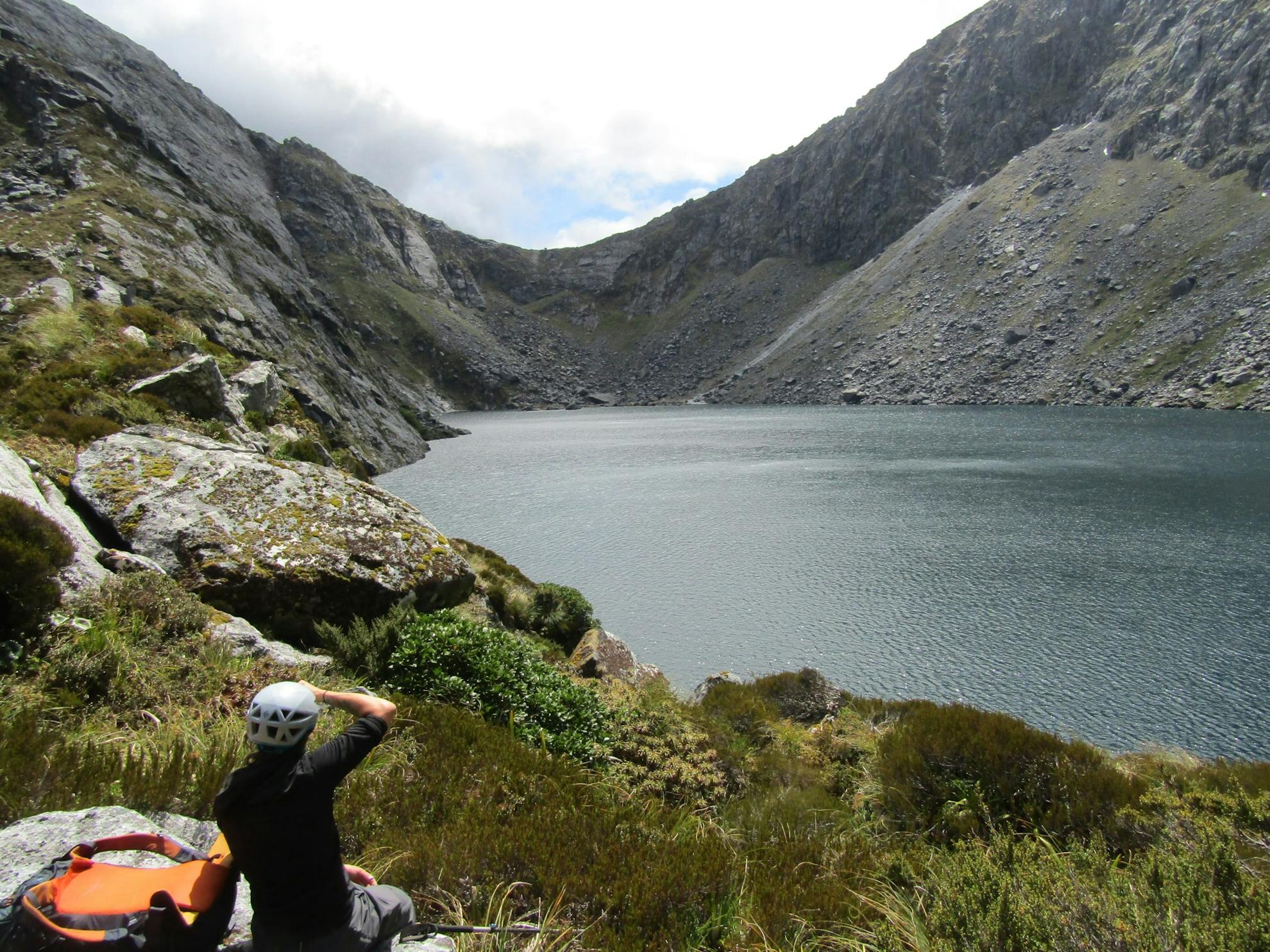
Soon though, we were heading to our valley of choice; the Clinton River North Branch.
It must be said that the travel we experienced in the North Branch was a far cry from the experience of Grave and co. There are now cut traplines providing good travel, which allowed us to reach a camp about four kilometres up valley. While Grave wrote that they rejoiced at the lightness of their swags, being ‘only’ 25kg per man, ours were a mere 16kg each, with dehydrated food, a light rope and modern camping gear. All in all, we had things pretty good.
Grave’s party had hoped to find a pass at the head of the North Branch, but a difficult journey upstream saw their hopes dashed by an impassable cirque. They backtracked and decided to try a hanging valley to the east, with an impressive cataract descending from it. They named this Epidote Cataract for the abundance of epidote crystals in the rock.
We began our ascent alongside the cataract in the cool of early morning. We looked across at the unnamed chain of mountains to the west of the North Branch, which seemed to grow ever taller as we escaped the foreshortening effect of looking up from the valley floor. A magnificent expanse of granite, just begging to be climbed.
‘Of all the hanging valleys I have seen, this is by far the most interesting,’ Grave wrote in his diary. ‘About a mile from the top of Epidote Cataract the valley seemed to end in a sloping, scrub-covered wall, about 1000 feet high. Toward the centre of this wall, ‘Flower Fall’, as we named it, descended with a drop of two or three hundred feet.’
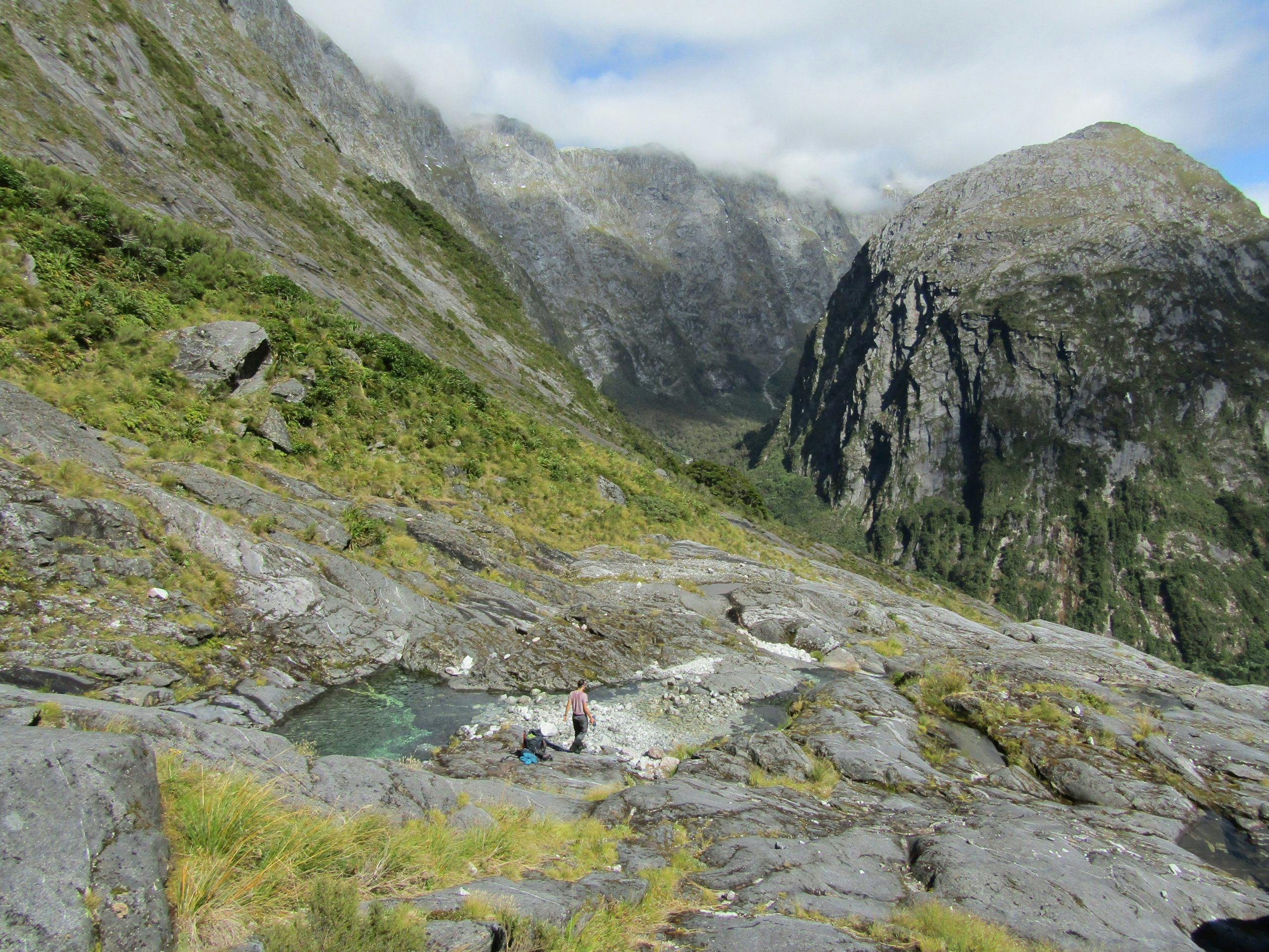
I couldn’t help but agree with Grave, the valley did seem to end with this imposing wall. A route alongside Flower Fall looked improbable from afar, and in fact we found that a slip had ripped away a section of the route described in Moir’s Guide, where I found myself battling with my nerves. After a good deal of investigation and discussion, we found a devious line that sidled through the bluffs with plenty of scrubby subalpine dracophyllum for handholds. It offered easy travel but I found it hard to relax while above those cliffs. It was with a good measure of relief that we topped out near the outlet of Lake Iceberg, so named in 1905 for the icebergs calving from the snow slope above. Today there is little snow around and no sign of icebergs, just circling seagulls and the sound of periodic rockfall.
Beyond the lake, we spied our first view of Marshall Pass, which Grave wrote they reached ‘after some difficult climbing’. If only I had taken that on board.
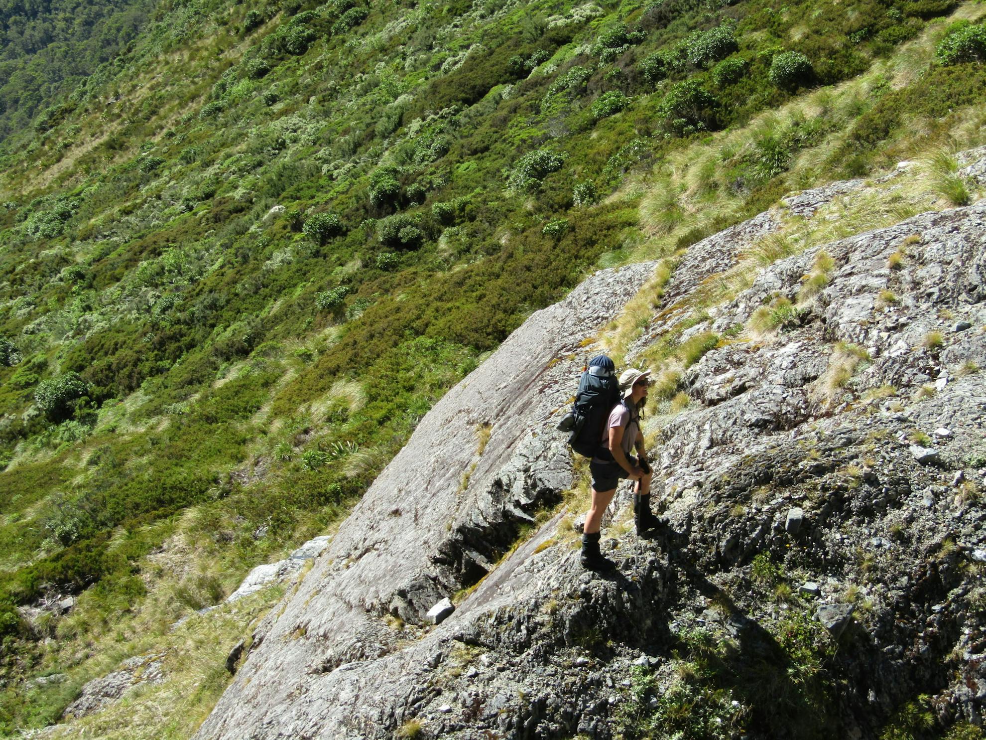
This first view was intimidating. The ‘pass’ seemed merely to be the low point in the ridge, presiding over a band of bluffs that looked impassable. We spent considerable time discussing possible lines, linking grassy or vegetated sections between the sheer rock faces, and took reference photos before going around the lake. At its head, we admired good flat camping options, then set off up the talus slope. A grassy ramp led to the base of the bluffs, from where there were narrow ledges filled with dracophyllum scrub. While on the earlier climb my awareness was consumed with the cliffs below, this climb had me trying my best not to notice our height. I couldn’t let myself look down, focussing my attention on finding good foot and handholds. We were both pointing out cracks that would take rock climbing protection if we had to downclimb or abseil our route. When the terrain finally mellowed out to steep tussock slopes, I grabbed fistfuls of the stuff, breathing in great gulps of air as my fear receded.
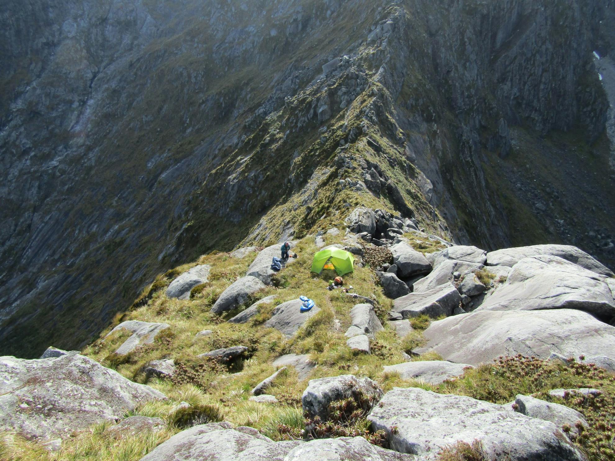
We were profoundly rewarded as we stepped onto the narrow ridge. The bright lush green of the Joes Valley below contrasted with the imperial grey of towering Fiordland granite walls. Grave also enjoyed this spot, writing: ‘We were refreshed by the magnificent view of snow-clad mountains and deep valleys.’ The scale of these mountains defies description.
We scouted up the ridge until we found a space to camp. This had to rank as one of the best campsites of my life, even if the only water available came from a dubious looking puddle, which we filtered through a beanie. The way the topography dropped away on either side of the ridge, giving unobstructed views, and the way the light played on the mountains around us, was unforgettable.
Descending into Joes River provided a playful morning of pure joy. Hundreds of metres of descent on warm granite slabs. Virgin streams fed tranquil pools of turquoise water, becoming increasingly large and impressive. All set against a backdrop of mountain Goliaths. I couldn’t stop grinning. Then we hit the bushline and everything I had read came back to haunt me. Moir’s promised a ‘wealth of rock and ribbonwood’. I would add a frustration of fuschia and fern. The bush bashing was unbelievable, through scrubby vegetation and hidden rocky crevasses. There followed several sweaty, sweary hours which put our friendship to the test. Eventually, I spotted with glee the first pink triangle marking a trapline. I cannot fathom the patience of men like Grave, who spent weeks picking their way through untracked Fiordland bush in all weather. The suffering they endured and that they chose to return time and again, speaks to a profound curiosity, love and admiration for this area.
The Joes Valley is certainly worthy of that admiration. It is just gorgeous – the surrounding peaks are majestic and the river is clear and blue. Even Grave noted, ‘here the scenery is exceptionally fine’.
The sandflies did their best to diminish our enthusiasm, but in our tent with the fly removed we could luxuriate in peace, lapping up the views. All that was left for our final day was to battle our way through the swamp upstream of Lake Ada, and re-join the Milford Track.
Our destination was a shallow section of the Arthur River that can be crossed on foot in low flow. To get there we pushed through head-high ongaonga nettle, vines and blackberry thorns on both shores. By the time we reached the Track, we felt like survivors of some sort of battle, filthy and bloodied. I could empathise with one member of Grave’s party who chose to sit down mid-crossing so that the pure waters of the Arthur might wash away the filth of the bog.
It was surreal to bump into the same cohort of Milford Track walkers we had seen at Clinton Hut two days earlier. What different experiences we had each had. At times I had been intimidated, frustrated, exhausted and scared, but I had also tasted that euphoria and deep love of place that must have motivated Grave and his friends.
Even as I boarded the boat to Milford Sound, I hungrily anticipated my next trip into Fiordland.
- Distance
- 51.3km
- Total Ascent
- 2937m
- Grade
- Difficult
- Time
- 4-5 days
- Access
- From the Dore Pass Track on the Milford Highway. Alternatively, take the boat from Te Anau to Glade Wharf
- Map
- CB08
