


There’s never been a better time to explore Aotearoa and these nine destinations look particularly good in 2021.
Kiwis are a funny bunch. We’re desperate to explore the far-flung reaches of Nepal or Europe on an OE, but when it comes to seeing our own backyard, we stick to the familiar: the Hooker Valley Track, Roy’s Peak or the Tongariro Alpine Crossing.
Here at Wilderness, we reckon there’s great satisfaction in stumbling upon hidden gems like these nine destinations.
1. Adventure island
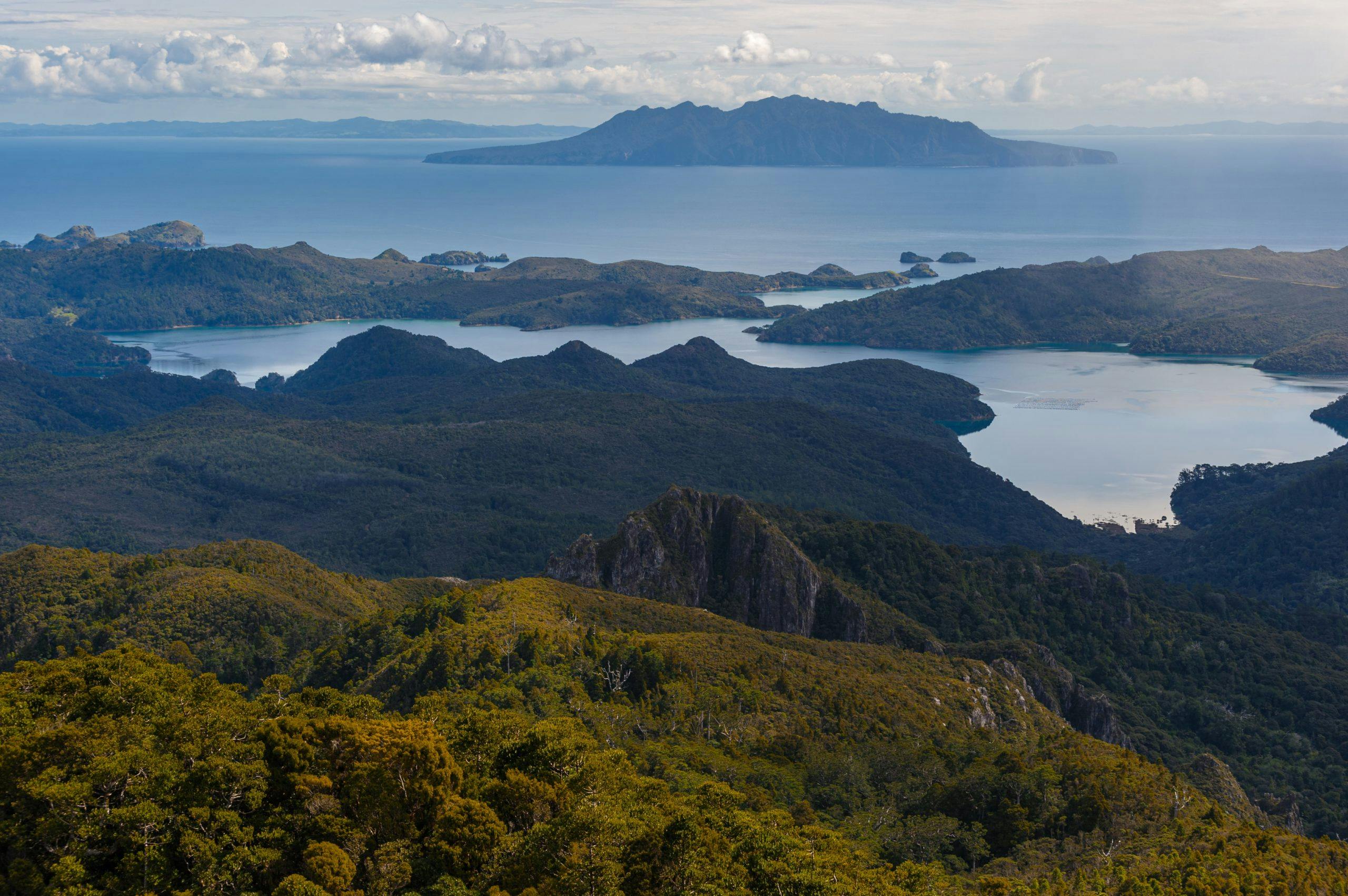
Aotea/Great Barrier Island, Auckland
Kākā wheel overhead, croaking as they alight in the pōhutukawa. Ablaze with crimson flowers, the tree’s gnarled limbs overhang the sea. White-sand beaches with wild surf in the east; rocky, forest-fringed harbours in the west. Inland rise monolithic rock faces, the eroded stubs of an ancient volcano, surrounded by vast forest swathes, including kauri. These are just some of the delights I’ve experienced on Great Barrier Island during my three visits.
Free of mustelids, Aotea hosts impressive birdlife including rare species such as pāteke (brown teal), kākā and black petrels. Some 12,300ha of the island is protected as Aotea Conservation Park, established in 2015.
Great Barrier is just a 30-minute flight from Auckland, yet it seems few Aucklanders go there to tramp – despite a range of tracks – plus two large huts. The largest settlement is Tryphena, where the Auckland ferry docks, while the airport is at Claris. Once there, you can hire a car, or book a shuttle, and choose your adventure.
Akapoua, Medlands Beach, Whangapoua, Whangaparara and the exquisite Harataonga Beach all have camping areas, and among dozens of day walks, perhaps the best options are the Dolphin Bay Track (3hr return), the Old Mill Track (2hr return), the Harataonga Coastal Walkway (4-5hr each way) and Coopers Castle Track (2.5-3hr).
For longer tramps, try a three day variant of the Aotea Track which begins from Aotea Road, climbs through Windy Gully to the 621m summit of Hirakimata/Mt Hobson which has views overlooking the western harbours, Te Hauturu-o-Toi/Little Barrier Island and the Auckland isthmus. A descent leads down to Mt Heale Hut (20 bunks), perched beneath the spire of its namesake mountain. By spending two nights, trampers can enjoy the lush forests and cascading streams on a circuit of the South Fork and Kaiaraara Tracks. On the final day, take the Peach Tree Track to Whangaparapara Road, with a soak at the Kaitoke Hot Springs en route.
The western harbours of Port Fitzroy and Whangaparapara make excellent sea-kayaking destinations, while the exposed eastern shoreline offers a lot less shelter and requires a lot more experience.
For mountain-biking, try the Forest Road Track between Port Fitzroy and Whangaparapara.
– Shaun Barnett
2. An under-appreciated underground
Waitomo, King Country
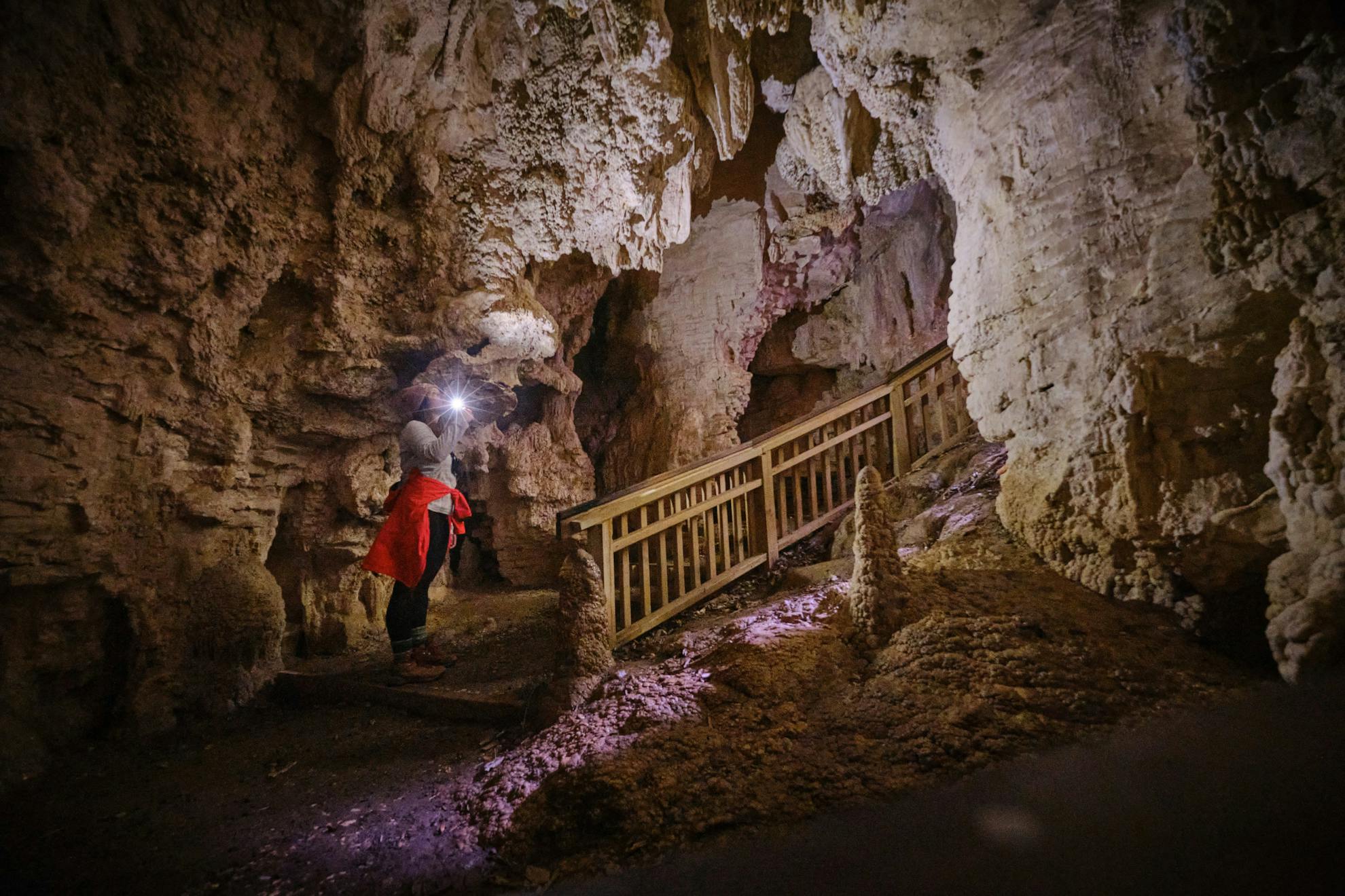
Along with Hobbiton and the Coromandel Peninsula’s Cathedral Cove, Waitomo is a rite of passage for international tourists before they cross Cook Strait. Though its caves are absolutely worth the hype, the region has earned a reputation as a sinkhole for tourist dollars, which pre-COVID would stream in by the busload.
These days, the village is as quiet as the caves that put it on the map, and there has never been a better time to explore its hidden gems.
On a recent trip, I enjoyed a quiet tour through two incredible cave systems, taking in the toothy stalactites, ancient moa bones and glowworms bright enough to read by. But you don’t have to spend any money to have an underground adventure here.
The Ruakuri Walkway is an excellent place to start. Before walking the 45min track, I spoke to an excited Australian visitor who’d just completed it. “Mate, it was amazing – just like Avatar,” he gushed. With Punakaiki-like pancake rocks, caves, tunnels and rugged bush, he wasn’t far wrong. Combine it with the 75min Waitomo Walkway for an excellent half-day experience from the village.
For family-friendly short walks, head west towards Marokopa and explore the Mangapohue Natural Bridge (a dramatic 17m limestone arch) Piripiri Cave and the beautiful Marokopa Falls – the most scenic in the region.
For longer adventures off the beaten path, trampers would do well to tackle the Tawarau Forest tracks, around half an hour west of Waitomo Village. The Tawarau Falls Loop Track, when combined with the walk to Double Falls, creates a challenging day walk including river crossings and limestone bluffs. The Gorge Track, meanwhile, could easily be confused for the Pororari River section of the Paparoa Great Walk, with its dramatic karst landscape, ferns and river.
– Matthew Cattin
3 Humble giants
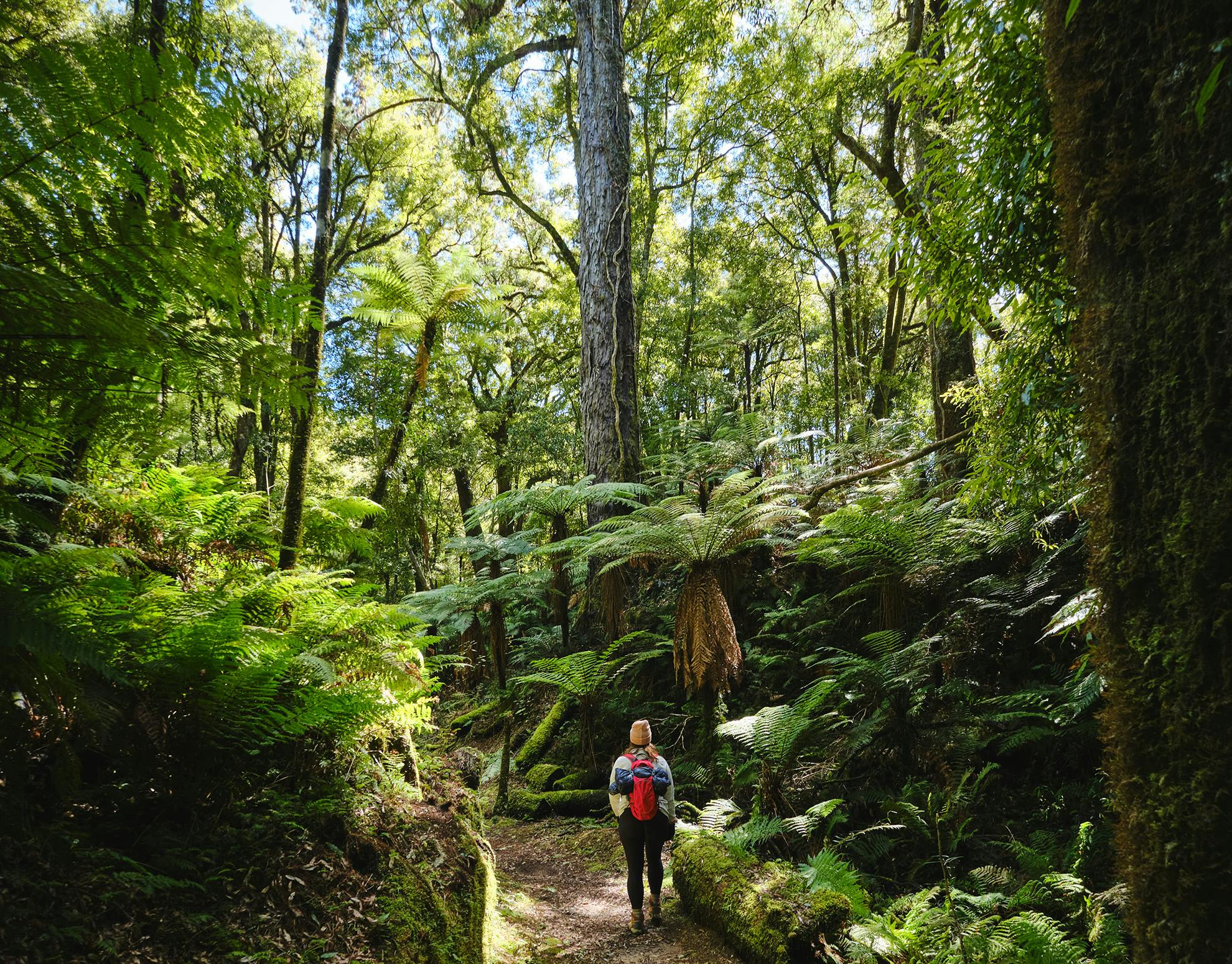
Whirinaki Te Pua-a-Tāne Conservation Park
My introduction to Whirinaki Te Pua-a-Tāne was unforgettable. Beneath prehistoric podocarps, my partner and I set off from River Road car park on a pale blue spring morning – already in awe of the humbling forest as we stumbled down the track, eyes fixed on the canopy instead of our toes. We arrived exhilarated at Te Whāiti-Nui-a-Toi Canyon – its columned walls alive with a stubble of moss. Approaching whistles echoed through the canyon, and in a scene straight from a BBC documentary, three low-flying whio rounded a bend in the canyon and skidded into the water below. Jostling about like boisterous teens, they dove and tousled in the current, before leaving us to digest our good fortune. Simply magic.
No matter where you are in Whirinaki Forest, it’s very difficult to watch your feet. Its podocarps – saved from logging by a famous conservation effort – can only be compared to the kauri giants of Northland, staggeringly tall and needle straight.
Whether visiting for a weekend or longer, there are walking options for every age and ability. Day walkers can do little better than the Whirinaki Waterfall Loop Track, a 3.5hr loop following the banks of the Whirinaki River, home to many whio which can be spotted from the banks. Shorter trips to the Arohaki Lagoon – a stunning wetland clearing – and Waiatiu Falls also impress, and a nightwalk on Sanctuary Track offers a chance to see kiwi, ruru and glowworms.
Regarded as the park’s premier tramp, the two day Whirinaki Track is a brilliant tramping option for most abilities, taking in the most popular features of the forest on a gentle track – though it will require transport or a car shuffle (Whirinaki Forest Holidays provide transport from $20pp). Longer options include the three day Mangamate Loop Track, or the epic five day Te Pua-a-Tāne Circuit, suitable for experienced trampers.
– Matthew Cattin
4 Unlikely jewel of the Manawatū
Palmerston North
When I moved to Palmerston North a few years ago, I realised there’s a catchphrase people use to justify why they live there: ‘It’s a great place to get to other places from.’ Damning with faint praise, but also thoroughly true; Palmy is generally less than three hours from most destinations in the lower North Island – Wellington, Ohakune, Napier, New Plymouth. It’s accessible to the Tararuas, Ruahines, Kawekas, Kaimanawas, and even Taranaki and Ruapehu.
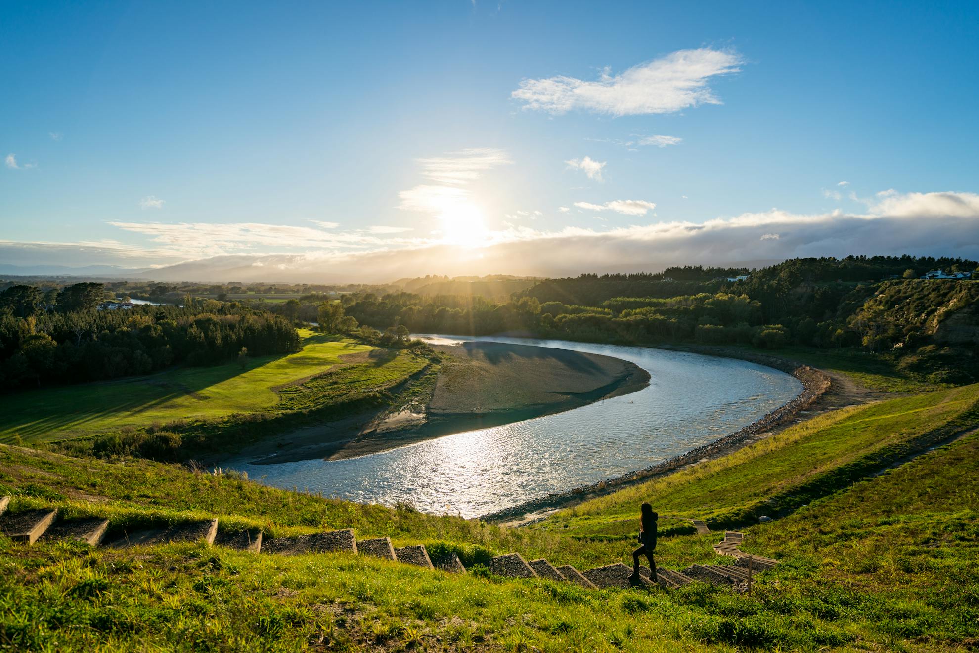
Palmy’s major attraction for the intrepid tramper is the Esplanade and Riverside Walkway, which runs along the Manawatū River. Join the whole thing up and you can do a 32km loop around the whole city – I recommend doing it on a bike.
A new attraction is He Ara Kotahi, a bike and footbridge across the Manawatū River. From here it’s 12km return on a newly hewn dirt path to the Linton Military Camp.
A short distance out of town there’s the spectacularly-shattered Manawatū Gorge, which won’t be restored to its former glory but a 12km track still runs high above it on the southern side. You’ll see a wind farm and scenic lookouts en route. A car shuttle is still possible via the Saddle Road between Ashurst and Woodville.
Te Araroa runs right through Palmy, so watch out for long-distance trampers walking through at pace. Shorter walks can be had on the Bledisloe tracks at Summerhill – and the nearby historic buildings of the Massey University campus are worth a visit, especially when the cherry blossoms are in bloom. Finally, the Stairway of Tāne is a top destination for those wanting to get their heart racing.
Finish off with a coffee from Mouthwater Coffee on Main Street – a little red coffee cart known for its dad jokes.
For a town known for being a good place to get to other places from, it’s not bad if you actually stick around.
– Hazel Phillips

5 Where sea and mountains meet
Kāpiti Coast, Wellington
The Kāpiti Coast forms a narrow strip of land sandwiched between the Tasman Sea and the Tararua Ranges and takes its name from the dominant feature on the horizon: Kāpiti Island.
The island has a fascinating history from being a fortress for Te Rauparaha, a whaling station, and a native bird sanctuary, and no visit to the Kāpiti Coast would be complete without a trip there. As one of the country’s first wildlife sanctuaries, it is home to many rare bird species, as well as a number of native reptiles. Two companies offer day trips (Kāpiti Island Eco and Kāpiti Island Nature Tours) or you can stay overnight for a good chance of seeing little spotted kiwi in the wild.
On the mainland, walkers and trampers have plenty of options, including Te Araroa, which passes through the region – notably the Paekākāriki Escarpment Track. When it opened in 2016, the track exceeded all expectations, and has since drawn tens of thousands of walkers. Perhaps it’s no wonder; the track offers expansive views of the coastline, an airy sense of height, and enough steps (over 400) to provide a decent cardio workout as it traverses steep slopes between the towns of Paekākāriki and Pukerua Bay. Train stations at both ends make it super-accessible. Allow 2.5-4hr each way.
Rising behind the township of Waikanae, Kapakapanui (1102m) is an outlier peak with an exceptional viewpoint of the Tararua Range. The summit makes for a demanding day walk (allow 7-8hr) or more leisurely overnight trip, with a stay at Kapakapanui Hut (six bunks).
Further inland, Ōtaki Forks is the main western gateway for Tararua Forest Park and a great place to take the family camping. Several rivers converge, all of them boasting swimming holes and opportunities for tubing. For trampers, Ōtaki Forks is the start of many multi-day trips, including the famous Southern Crossing and Tararua Peaks.
– Shaun Barnett
6 The end of the road
Karamea, West Coast
In a literal sense, Karamea is a true destination. By road, there is only one way to get there – a 90 minute drive from Westport, sidling around the gnarly Radiant Range and up the rugged coast. It’s a quiet cul-de-sac of a town that nobody passes through – if you’re there, you’re there for a reason.
Karamea will be familiar to trampers as the southern end of the Heaphy Track, and I couldn’t imagine a more suitable place to ease trampers back into civilisation. At its back, Kahurangi National Park rises out of the sea mist, and to the west, the Tasman Sea drives a barrage of driftwood onto the shores. The last census put the population below 400 residents and the locals are about as removed from the rat race as it’s possible to be.
Getting there is half the fun. A visit to the abandoned remains of Denniston – a depressing and dangerous coal mining settlement – gives an insight to the hardy folk who called the area home, and the easy Charming Creek Walkway, accessible via Ngakawau or Seddonville, is worth a nosey.
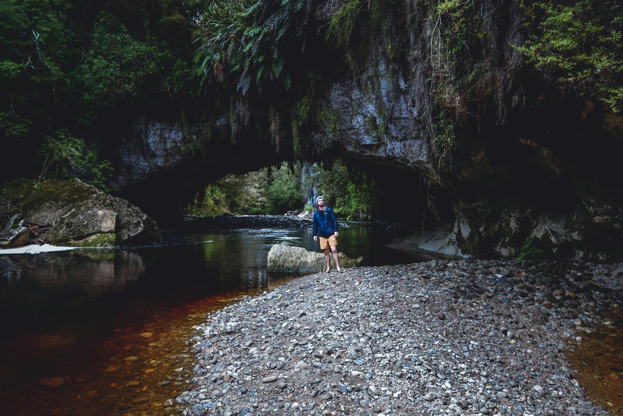
From Karamea, a trip to the Ōpārara Basin is essential. The Ōpārara Arch is the largest limestone arch in Australasia, and quite unlike anything else in New Zealand. With hanging flora, moss and stalactites, the nearby Moria Gate is equally impressive, though much smaller. Watch out for cave wētā and the endangered Nelson cave spider, New Zealand’s largest.
Longer walking options include the 5hr Fenian Track, which links the Fenian Road car park with the Ōpārara Basin via impressive caves, or sections of the Heaphy Track to the north.
Pro tip – check the hours of Karamea’s gas station before your petrol light comes on to avoid a white knuckle drive back to Westport.
– Matthew Cattin
7 Day trippers paradise
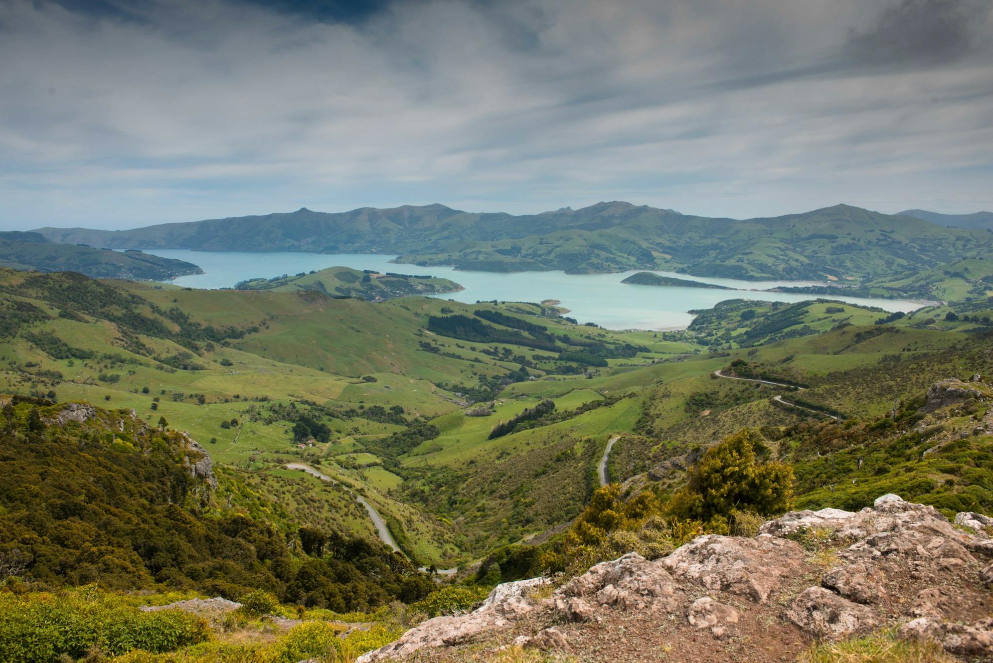
Banks Peninsula, Canterbury
On a fine, clear day, especially in spring or summer, the view from the Summit Road is supreme. How could it not be? With those rolling green meadows swooping down through bushy gullies to the tantalising sparkle of the ocean, Akaroa Harbour is rimmed with bluffs and headlands, seabirds soaring above on coastal breezes, and a limitless horizon curving toward the sky beyond the hills.
Banks Peninsula and its many bays and harbours are the day-trip-capital for Cantabrians, Most of the walks accessible from the road are doable within 30 to 90min, particularly those that scurry to the top of the many volcanic tors that jut from the landscape.
Along the Summit Road from Hilltop, you can climb through native forest in Montgomery Park Reserve, then drive down to beautiful Pigeon Bay, visit Hay Reserve, historic Annadale Homestead (booking required), and head out on the Pigeon Bay Walkway to Wakaroa Point.
Continuing along the Summit Road there’s a side road at nearly every saddle dropping seawards to visit a remote bay and settlement like lovely Little Akaloa or historic Okains Bay and its excellent museum. Akaroa Harbour is named with the charming French-themed town of Akaroa where the French landed and almost claimed New Zealand for France.
A half day could be spent here sampling its mixture of cafes, shops, historic landmarks and easy walks or taking the famed Black Cat harbour cruise out to the heads.
With time and planning you could also do the three-day Banks Track which begins just out of Akaroa and heads up and over the hilltop to the ocean bays to the east. It’s popular, spectacular, has varied wildlife, and visits many remote bays and farms. At the head of Akaroa Harbour is Onawe Peninsula – a pā site – plus beautiful French Farm and Wainui Bay and the wild Bossu Road back to Little River.
– Pat Barrett
8 Lakeside and mountaintops
Lake Hāwea, Otago
Lake Hāwea is often overlooked as a destination because spectacular Lake Wanaka is so close by.
However, this deep and strikingly beautiful lake is notable not just for the serried ranks of schist mountains that dominate its shores but also for the many isolated and memorable walks and mountain biking trips that can be enjoyed around the shore and along the Haast Pass Highway.
I especially like this part of Otago as it begins to feel much more like wilderness New Zealand, away from the main towns and highways, where the journeys into the hills contain a palpable sense of isolation and endeavour. Take the Hunter Valley, a major feeder of the lake running for 40km into the mountains within which is a plethora of tramps and pass-hopping adventures. You’ll need time for this one, at least 4-5 days, with the best access being off the Haast Highway.
Closer to Lake Hawea township is the Te Araroa Trail which heads over Breast Hill past Pakituhi Hut to the Timaru River. Farther up the lake on the eastern side is the beautiful Dingle Burn Valley and huts, and a mountain bike trail all the way to the lakehead.
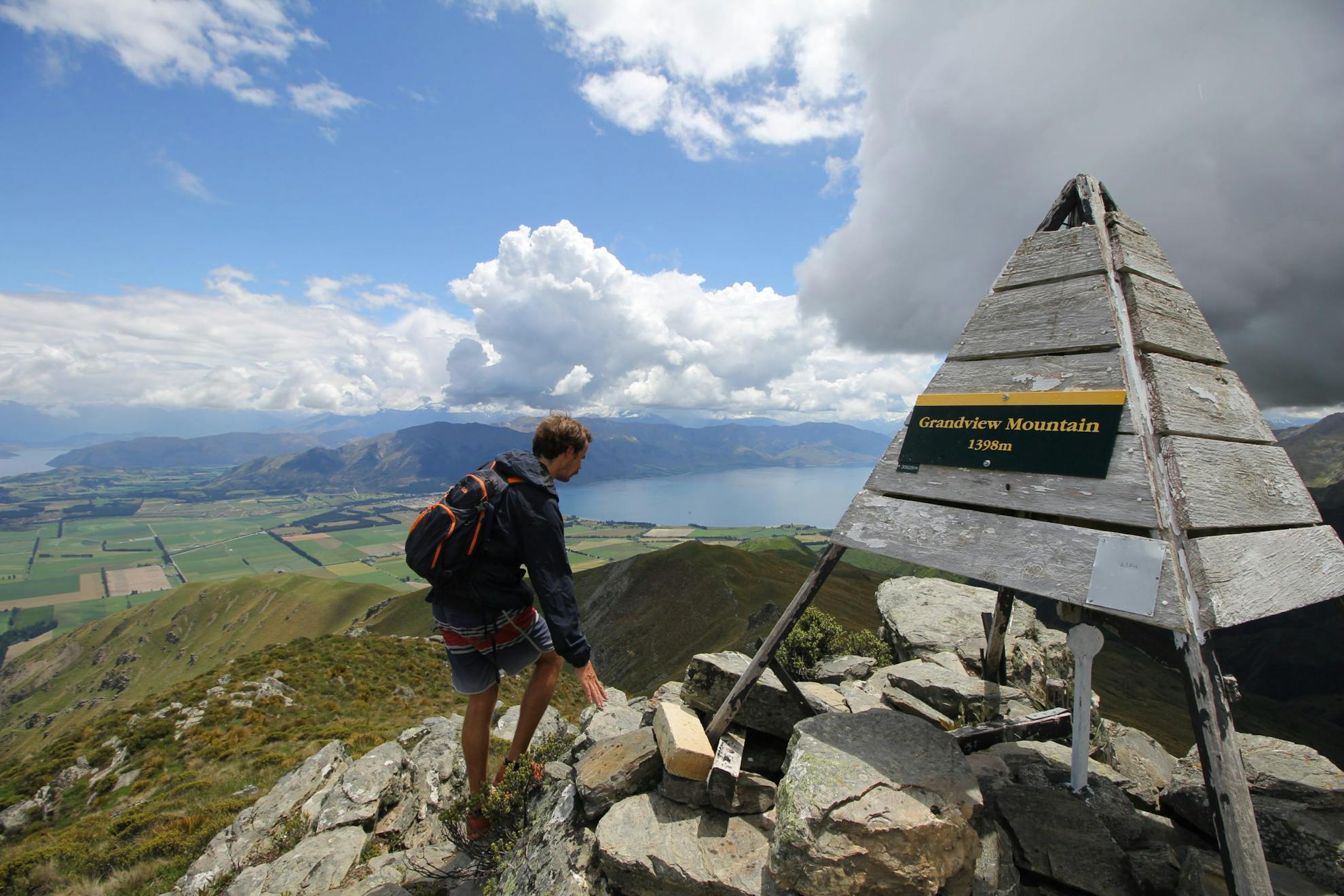
South of town is the short, steep hike to Grandview Mountain – an excellent viewpoint – while on the western shore is the hike to Isthmus Peak, 1386m, and the skyline traverse to Lake Wanaka – a fantastic trip that can also be done by bike.
At The Neck is road access to Kidds Bush camping area and the track into Sawyer Burn and Sentinel Peak.
The wilderness experience at Lake Hawea has endless opportunities.
– Pat Barrett
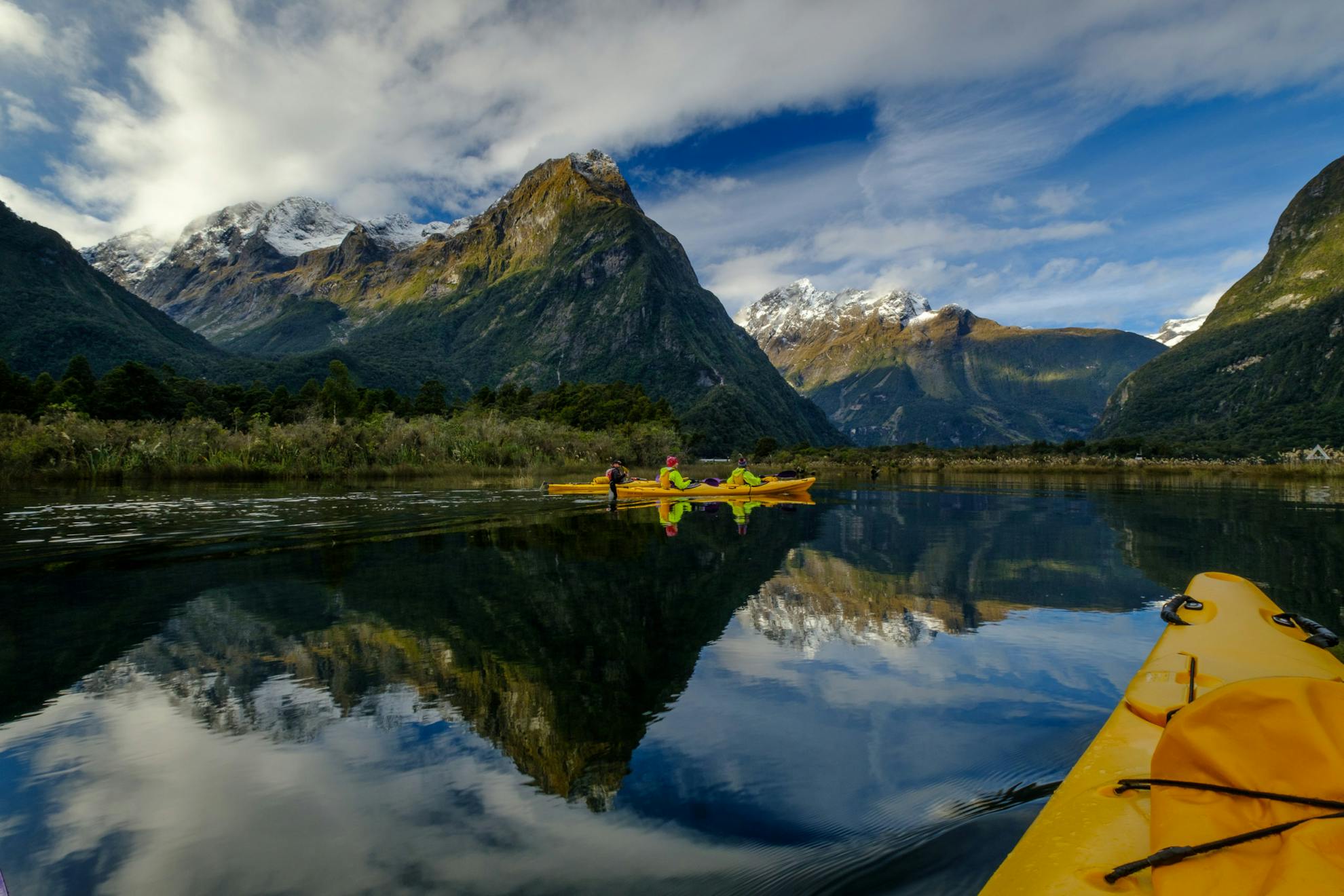
9 From forest to granite and sea
Piopiotahi/Milford Sound, Fiordland National Park
The journey to Piopiotahi/Milford Sound is as memorable as the destination. My first experience left such an impression that it cinched my desire to one day live and work in Fiordland. Perhaps it was along the Avenue of the Disappearing Mountain that I left my heart or perhaps it slipped out beneath the waterfalls of the Homer Cirque. Whatever the case, it is a place worth visiting time and time again – and more so now that tourist hordes and associated bus traffic are absent.
The two-hour drive from Te Anau to Piopiotahi/Milford Sound provides many opportunities for long and short adventures, whatever the weather. Like any good theatre, the experience is improved by a bit of suspense. Top tip – if it’s raining don’t fight it; embrace it! Thundering waterfalls at every turn or fresh snow on the peaks is like chocolate on top of already delicious ice cream.
With a few hours up your sleeve, you can enjoy sweeping mountain views in fine conditions or the power of Fiordland in a storm on a short walk. If the weather allows, consider reaching Lake Marian (3hr return) for a grand setting that feels a world away. Or, if walking steeply uphill isn’t your thing, go for a stroll along Gertrude Valley to marvel at the sheer granite walls that make Fiordland famous.
Ultimately, when Mitre Peak comes into view as you round the bend into Piopiotahi/Milford Sound, you are transported into a scene that graces many postcards yet has a beating heart that can only be felt in the flesh. If you want to feel smaller than ever, hop into a kayak and paddle beneath the 1600m walls of the fiord or simply go for a walk along the Milford foreshore (especially good at low tide).
Spending the night in Milford enables you to begin the day like no other. Wake up on a cruise vessel anchored in the fiord and savour the quiet of the expanse before dawn. Or sleep in the forest-surrounded Milford Sound Lodge and hop on a boat the next morning for a short trip to the base of Lady Bowen Falls for a singular up-close experience of the falls.
– Crystal Brindle
