


- Area
- Fiordland National Park
- Time
- 8-10 days
- Grade
- Difficult
- Accom.
- Upper Spey Hut ($5, 12 bunks); Kintail Hut ($5, 12 bunks); Loch Maree Hut ($5, 12 bunks); Supper Cove Hut ($5, 12 bunks); Lake Roe Hut ($5, 12 bunks); Halfway Hut ($5, 12 bunks); Hauroko Burn Hut ($5, 10 bunks)
- Access
- Most people walk in the opposite direction to that described in this story. Both ends of the track are only accessible by boat. Some parties fly into Supper Cove by float plane or helicopter, then walk out
- Map
- CD06, CE05, CE06
Ray Salisbury survives New Zealand’s hardest hike – Fiordland’s Dusky Track
Our meticulous planning had us book the bus, boats and backpacker beds months in advance. Alas, we couldn’t book the weather. Doing the Dusky, New Zealand’s most difficult track, is not straightforward. The 84km route is about the same length as the Heaphy, but takes twice as long due to the rugged terrain. It’s similar to the Milford Track, in that both track ends are only accessible by boat. But all similarities with Great Walks end there.
Mention the Dusky to those in the know and you will hear tales of knee-deep mud, voracious sandflies and non-stop rain. It’s a true classic, a rite of passage. It has a splendidly nasty reputation.
Our trio embark on a Real Journeys vessel at Pearl Harbour, a stone’s throw from Manapouri. Surrounded by a horde of camera-toting tourists, we cross the 414m deep lake renowned for its fickle and furious winds. Today, however, all is calm as we slide past such landmarks as The Monument and The Beehive.
Gazing at the view, I recall that a pioneering family first opened up this region to tourists. In 1900, Robert Murrell built huts at West Arm and Deep Cove. Later, his son Les repaired them and ran a guided tramp to Doubtful Sound, rivalling the Milford Track. In 1954, a different Les – Hutchins – purchased the Murrell’s boats and operations; these eventually evolved into the present-day Real Journeys operation. Sadly, the walking track was destroyed to make way for the road over Wilmot Pass.
An hour’s sailing to West Arm brings us to New Zealand’s largest hydro-electric power station. We board the busses headed for Deep Cove – at the head of Doubtful Sound – but after 10 minutes, the driver drops us off at the trailhead.
We heft heavy 10-day packs and disappear into the ribbonwood and dense beech. An hour of strolling along the mid-reaches of the Spey River, and our brisk pace is brusquely halted at the first bog. My new gaiters are baptised in knee-deep mud; I am being swallowed by the track. Fighting to stay upright, it takes a huge effort to manoeuvre onto solid ground.
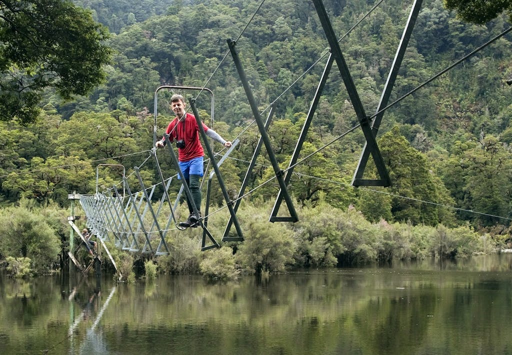
The afternoon slips by and we encounter the first of 21 walk-wires – three cables strung taut between tree trunks. We climb on to the structure, then cautiously traverse the lower wire like a tightrope, holding onto the high wires with both hands.
We play a game of ‘I Spey with my little eye’ to amuse ourselves, before a boardwalk betrays the location of Upper Spey Hut. A black cloud of sandflies enshrouds the cabin, so we dive inside, boots ’n all.
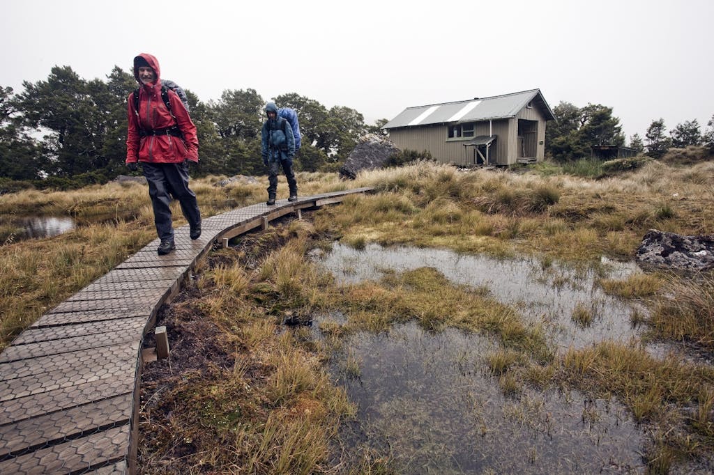
Trampers depart Lake Roe Hut for drier and warmer climes. Photo: Ray Salisbury
We are not alone. Honeymooners from Auckland are doing their first South Island tramp. A mature German couple arrive later, looking worse for wear.
The good weather is holding – just – as we dance along boardwalks that give a false sense of security. The track abruptly hits the valley wall and climbs mercilessly upward, with no switchbacks. A 60-degree rock step requires careful footwork to ascend. Eventually, we top out into a hanging valley; a subalpine world of tussock and beautiful wild flowers.
The track meanders up and over Centre Pass; the sheer face of Mt Memphis, 1405m, looms large to our left, luring my companions up the hill in search of a higher viewpoint. I am content to eat lunch, and chase a lone kea with my camera.
A chill southerly funnels through the saddle and ominous clouds are building. I wrap myself in polarfleece, sheltering behind a wall of packs. After an age, Malcolm and David return jubilant from the summit of Memphis. I lead off downhill where the trail cuts a silver thread through a tussock basin, skirting a smattering of tiny tarns. But below the bushline, we strike an impasse: a three-metre drop that needs some nerve to negotiate. Beyond this hazard, the terrain is rooted and rough underfoot; a relentless full-body workout that saps our energy.
As we pass through the cloud layer, the distant outline of Gair Loch is revealed, with the impossibly angled pyramid of Tripod Hill towering above. We are nearly at the bottom of the hill, but the Dusky isn’t finished with us. A couple of cliffs fall away below. Malcolm free-climbs out of view, while David and I abseil down using the long lengths of chain.
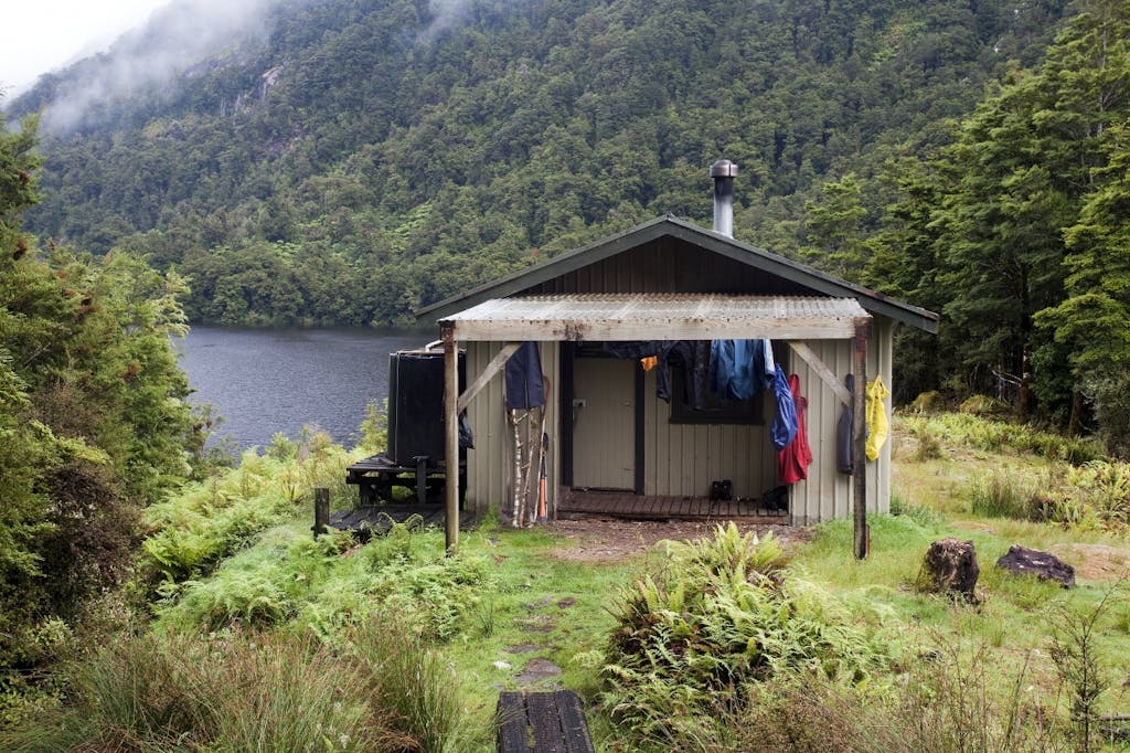
Striding out beside Kintail Stream, we encounter impassable tree-fall. We follow a marked detour and cross a pair of walk-wires to finally reach the safety of Kintail Hut, which has squatted near the Seaforth River since 1975. We have been on our aching feet for nine hours and feel exhausted.
Next morning, David boils the billy. Rain hammers the hut roof and I want a pit day. My mates urge me into action. Wrapped in raincoats, we stroll past the restful reaches of Gair Loch. We march across river flats, searching for elusive markers in the scrub. Side-streams are forded, wet boots are ‘the new normal’. Sweating in the humidity, we strip down to tee-shirts and shorts.
At our riverside lunch spot, a lone whio glides across the river. It is a touch of serendipity that lifts our flagging spirits. Later, we find ourselves hanging onto a handrail chain above the river, trusting tiny footholds to support our weight.
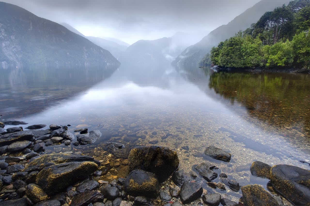
The entire valley has widened; the Seaforth River has slowed to a snail’s pace, snaking from bank to bank, before merging into Loch Maree. Here, rotting stumps punctuate the moody waters; remnants of a drowned forest.
Loch Maree Hut follows the 12-bunk design of Chief Ranger Murray Schofield who, in 1967, supervised borstal inmates to develop the Dusky Track. Not much has changed since. Ducks quack, pigeons preen their fat bellies. Malcolm reads the pile of ancient Nat Geos while David prepares supper – but only after implementing his search-and-destroy policy on every sandfly trapped inside the hut.
In the morning, David coaxes the cooker to life and we drink tea before returning to the track, skirting the misty shores of the loch, traipsing over three-wires, which are now so familiar we no longer fear falling from them.
Under an oppressive layer of cumulonimbus, the sunlight seems exhausted. By the time it reaches the forest floor, it’s but a memory. Then the rain comes down – in bucket loads. But we’re wearing yesterday’s wet gear so we don’t care.
The Seaforth seems lethargic, like me, slowly moving toward the Tasman. The only sound is the unremitting rain and our boots trudging through the sludge. Occasionally, we hear birdsong or pass a magnificent cascade which interrupts the eerie silence.
This section of trail to Dusky Sound was cut in 1903 by 50 gold miners, under orders from the government. They were paid $1.25 a day. But the miners quit not far beyond Loch Maree. I could only assume the wet, mud and vicious sandflies drove them out. But they weren’t the first white men in these parts. That honour belongs to Sir Thomas Mackenzie, who mapped an overland route to Dusky Sound between 1894 and 1896. He was to become New Zealand’s 18th prime minister.
Loch Maree Hut was home to tramping troubadours from around the world. Photo: Ray Salisbury
We strike a regular rhythm along pleasant river flats and I begin to enjoy myself at last. We are travelling through our own private worlds, singing hymns, or tunes recalled from our childhood… ‘Mud, mud, glorious mud!’
After five hours, there is the roar of a tumultuous waterfall plummeting through foliage into a frothing pool and we emerge from the suffocating forest into the open, north-eastern corner of Dusky Sound. This fiord was named by Captain James Cook in 1770 and explored on his second voyage in 1773 by longboat as far as the Seaforth River.
Standing on the shores of Supper Cove, our elation is short-lived; the tide had not dropped sufficiently for us to cross the mudflats directly to Hilda Burn Hut. A painstaking detour is undertaken, scrambling through moss-covered wind-throw and over arthritic roots.
In 1910, an ambitious attempt was made to introduce Canadian Moose into Fiordland. Hand-reared in Canada, four bulls and six cows were quarantined on Somes Island and shipped in crates to the remote reaches of Dusky Sound. The last moose was shot in 1971. However, the hut book tells tales of catching rig shark, groper and blue cod in these murky waters. So Malcolm tries his luck with a land-line using salami bait. Thunder resonates, then the full force of a front hits, sending us scurrying like drowned rats to the shelter.
Fog cloaks the sheer walls of the fiord in the morning. Supper Cove is in a sombre mood, like me. Assuming the exposed tidal flats will provide a quicker exit, we splash into the freshwater outflow, but my friends soon turn back. I stubbornly push on, cautiously fording the Hilda Burn at the mouth, aware that if I stumble, the current could send me seaward.
Inching around a peninsula, I clamber around sunken trees at a snail’s pace, chest-deep in the dark, brooding waters. Then the rain begins to fall. With the incoming tide and the threat of sharks, I revoke my foolish decision and return to the hut. As Shackleton once said to his wife: ‘Better a live donkey, than a dead lion.’ Soaked to the skin, some 40 minutes behind, I am subdued. On the treacherous high-water route I lose the track markers, but manage to keep calm, and carry on.
Reunited with my mates, we head up the brown Seaforth River, now boiling over its banks, convulsing like an electrically stimulated muscle. I keep moving to maintain my body heat, splashing through tannin-stained streams and muddy bogs with a contempt I didn’t have yesterday.
It takes six hours to return to Loch Maree Hut. Two Aussies are in residence and we indulge in good-natured banter about World Cup rugby. Soon, the hut gets busy as a Frenchman, Englishman and a Cantabrian arrive.
Waking to heavy rain, Malcolm and David visit the long walk-wire spanning the Seaforth. Our escape route is flooded; the surging torrent has risen nearly two metres, cutting off access to the Lake Roe route. I secretly smile: rest days are the best days.
By late afternoon the rain has abated, so we return to the bridge. The water has dropped and a Czech hiker appears. He wades across, chest-deep, to the ladder, and joins us on the walkwire. By early evening, more trampers arrive and the 12-bunker is chocka, wet clothing hangs everywhere.
It’s midnight when the rain returns with a vengeance. I can’t sleep with worry. Will we be trapped for another day? An entire week?
At 5.30am, David disappears into darkness. He’s back at 6am, white-faced and imploring us to depart immediately – it could be our only opportunity. We stash sweaty sleeping bags into our damp packs and creep outside.
In the gloomy half-light, we tiptoe along the steel cable and descend the access ladder to discover the water has dropped a whole metre. Splashing to the security of the far bank, we pause to brew tea at the emergency shelter and scoff a hasty breakfast by torchlight.
The arduous ascent onto the Pleasant Range begins immediately. According to local deer-culler Val MacKay, he was asked to mark this route for the Park Board in the early 1960s. He assumed the track cutters would add in zigzags, but they didn’t. As we crawl up, it becomes a rushing waterway and we climb a vertical rock face, using a chain for support.
Eventually the treeline is reached and snow poles beckon us upward, climbing over the knobs and unnamed peaks of the Pleasant Range, a total misnomer: the land is sodden, the rain relentless, and I am soaked through. I feel the onset of hypothermia, my thighs are burning and I’m short of breath. We head further into the fog, then sidle around Lake Horizon.
Finally, our roller coaster ride drops to Furket Pass and Lake Roe Hut. The deluge worsens once we’re safely inside. I stoke the woodstove in a feeble attempt to heat the hut.
While sorting through our dwindling rations, we debate the difference between mist, drizzle, light rain and a real storm. Will our sketchy assortment of pita bread and muesli bars be enough? At least the sandflies can’t touch us, here in the clouds.
Malcolm tiptoes along the three wire bridge over the swollen Seaforth River. Photo: Ray Salisbury
After a deserved sleep-in, we emerge from our soft world of down and fleece and stumble into the mist. The wind is gusting; the rain steady. We haven’t seen the sun for an entire week.
Days of perspiration has dried on my clothes; my chin is prickly from a week without shaving. But this rough living has awakened something deeper inside my soul. A slow realisation occurs and the suffering becomes almost enjoyable, as if all the rain, the wilderness itself, were an acid dissolving the superficial shell of urban existence.
We descend into the headwaters of Hauroko Burn. Skirting Lake Laffy to drop into the saturated bush we are soon on level ground and our pace lengthens over the easiest section of the trail.
In just 3.5hr we burst through a clearing, break the sandfly barrier and enter Halfway Hut. David soon has a fire roaring in the open hearth.
Long after dawn, we peer outside to see streaks of pale blue between the puffy clouds. Easy flats along Hauroko Burn lull us into a sleepwalk.
We spot a flock of excited mohua, another touch of magic that lifts our mood. The final leg is delightfully cruisey, parallel to the Hauroko, which is now a spent force, sluggishly seeping into the lake. There’s just one last walkwire before a forest of crown ferns and horopito to the Lake Hauroko shoreline. Malcolm and I strip to our shorts and bathe in the country’s deepest lake – 462m.
Two hunters arrive in their boat. Inside Hauroko Burn Hut, they feed us beef sausages and we chat by candlelight. Their dogs are content to sleep on the floor, beneath the bottom bunks.
After 10 days, all that is left to do is wait for our scheduled boat ride. The appropriately named Namu (Maori for sandfly) arrive mid-morning.
The Dusky Track deserves its rugged reputation. If soft living kills the soul, then doing the Dusky brings a deep awareness of feeling alive; a long-lasting sense of satisfaction.
It was so far, yet so good.
