


- Time
- 3-4 days
- Grade
- Moderate/Difficult
- Accom.
- Tin Hut (private), Top Timaru Hut, Stodys Hut, Pakituhi Hut
- Access
- Birchwood Rd car park, Gladstone Reserve, Timaru River Rd Grade: Tramping track
Ignoring the physio’s advice and continuing with a sprained ankle isn’t the best idea when heading deep into the Otago high country, discovers Jonathan Carson
I didn’t know it yet, but I shouldn’t have been here, standing on the roadside in Lake Tekapo with my thumb out for a ride south.
I had limped into town the day before to rejoin Ben, a great friend who I had been hiking the length of the country with for three months, loosely following the Te Araroa Trail. It was a return from injury following two weeks of resting and restlessness with a sprained ankle.
“Take it easy for four to six weeks,” the physiotherapist had said.
No way, man, I thought. I’d been off the trail too long already. Besides, the worst of Te Araroa was behind us now – or so I thought.
It didn’t take long to catch a ride. Garrick, who runs the famous Cinema Paradiso in Wanaka, pulled up in his old truck and told us to hop in.
It was a 90 minute drive on State Highway 8, through South Canterbury’s golden hills that once moved with rabbits, and past Lake Pukaki and Lake Ohau, giant bowls of electric blue that reflected newly snow-dusted mountains.
Garrick said he had hiked to Breast Hill and back from the southern end in a day. “How was it?” we asked. “She’s pretty bloody steep,” he warned. “You boys’ll be alright, though.”
Garrick dropped us at Birchwood Rd, a gravel farm track that leads to I-don’t-know-where. The start of the track is about 11km along it. After trudging for a half hour or so two cars, spitting dust and stones, came rumbling behind us.
“Should we?” I asked Ben. “Yeah, alright.” We chucked our thumbs out and flashed smiles. The occupants were cautious folk and sized us up good and proper. “There’s not much room,” one said. “We can squeeze in,” we assured them. They fumbled for another excuse before settling on “oh, okay then”.
It was mid-afternoon by the time we got started on the track and we knew we wouldn’t cover the 23km to the first hut, Top Timaru Hut, before dark. We’d be sleeping in our tent, we thought.
The trail begins across Longslip Station and follows a fence from behind which trophy deer gawk curiously at visitors. My ankle felt good on the gentle farm track and tussock grasses, but occasionally a wrong footing would send a sharp jolt through my body. I had to watch every step. But it felt good to be walking again, breathing real air on a cloudless afternoon.
Without the promise of a roaring fire to dry our gear that evening, we took our boots off to ford Avon Burn, a thigh-high catchment that was flowing swiftly after a week of rain and snow. Soon after we encountered a tramper who told us she and a group of friends, who were lagging behind, had walked to the hut for lunch. “The hut?” we asked. “Yeah, there’s an old private hut about five k’s back,” she said. “The door’s unlocked, I think it’s okay to stay there.”
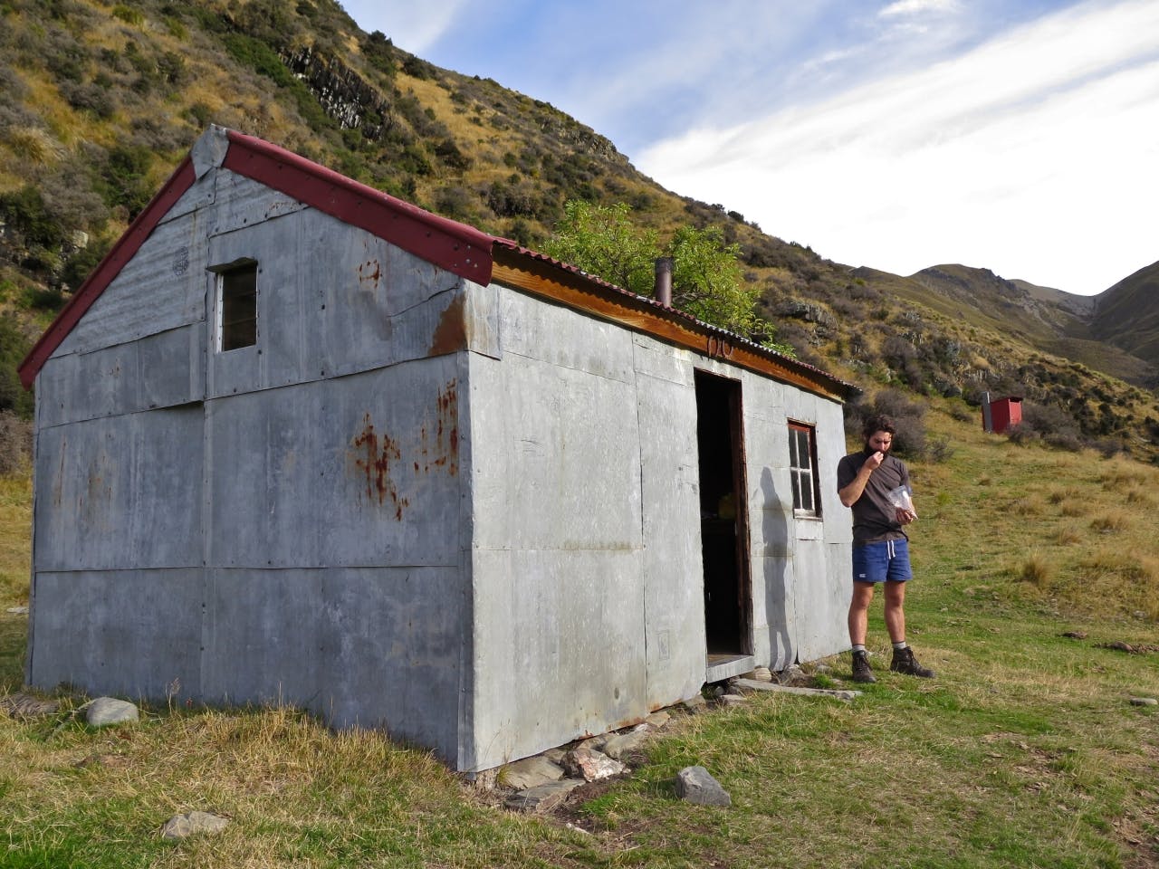
The inconspicuous Tin Hut. Photo: Jonathan Carson
This was news to us, so we thanked her and pressed on.
The aptly named Tin Hut sits inconspicuously at the foot of a hill above Avon Burn. Its exterior is constructed entirely of weathered grey steel, with the exception of the wooden door, two tiny windows, and a tree that seems to be growing out of one corner. I nudged the door open and there, at the entranceway, was something I have never seen in a hut before – an upholstered lounge chair with wooden arm rests.
“This doesn’t look too bad,” was my first reaction.
I shuffled in to the homely wooden box. There was wood and a sack of coal for the old stove, five wooden slat bunks, a few dirty mattresses and blankets that I wouldn’t let a dog sleep on. It must have been built by the landowners as a musterers hut some years ago, we thought. It was beat-up, but had plenty of charm.
We weren’t sure of the rules about staying in a private hut and considered walking further and setting up the tent someplace before Mt Martha Saddle, but then we saw the tattered red notebook in a sealed plastic bag on the bench. It was Tin Hut’s unofficial intentions book filled with pages of scribbled notes from hikers who had stayed the night, many raving about its ruggedness and, of course, the cushioned chair. It was settled. Tin Hut would be home for the night.
Ben got a small fire going and we huddled around with our usual pasta, tuna, cheese and garlic salt concoction. It was delicious the way any meal is when it’s all you’ve got. We read books, not talking much, before settling in for an early night.
It was a restless sleep, broken and uncomfortable. Our polyester tent was warmer than this old shed. We brewed a pot of tea and watched the sun throw light on the mist that was moving through the valley. The cold was crippling and we wanted to get moving early, both to warm up and to give us plenty of time to walk the 25km to Stodys Hut. I did the stretches my physiotherapist told me to do, massaged some cream into my ankle, pulled on my compression bandage and set off.
Snow was scattered like bones across the rocky slopes ahead of us. It was the first time I had encountered snow on Te Araroa so, naturally, I was excited. The bulldozed track up to Mt Martha Saddle was paved with the white stuff, knee-high in parts, and I stomped through it with childlike glee.
The ascent to 1680m was slow and steady and at a gradient that was just right for my ankle, but I had to skip and hop my way down. Whenever I slipped behind, which was often, Ben would holler something like, “How’s it going, Skippy?” and I would tell him I was okay. But by this time I was beginning to realise that I wasn’t.
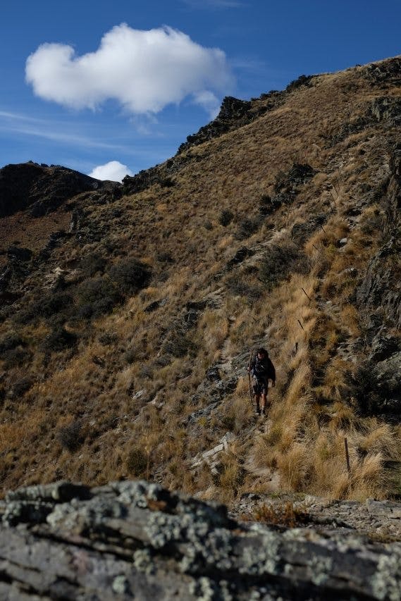
Final Descent, 950m, to Timaru River Road. Photo: Ben Curran
We arrived at Top Timaru Hut, a cosy six-bunk cabin on the Timaru River, right on midday for what we thought would just be a lunch break. That was until I saw a map on the wall that said we had another 7-8 hours of hard tramping to Stodys Hut. Usually we would look at a suggested track time and divide it by two, but in my current physical condition I was far less optimistic.
“I don’t know if it’s a good idea,” I told Ben. Of course it’s a good idea, he said. The conversation went back and forth like this until our voices betrayed the faintest traces of anger. It was the closest thing to an argument that we’d had on the trail and we ate lunch without speaking.
When we’d done eating Ben agreed to stay and I felt guilty as hell. We had half a day to kill in this poky hut and it was my fault. It was the longest afternoon of drinking tea, reading books and lamenting the library left behind by others. People should heed DOC’s advice and take their trash with them, Ben said of the paperback collection. The intentions book made for better reading.
At the end of the bulldozed track, which follows the river downstream to the tree line, is the entrance to hell. The forest trail, a balancing beam of loose dirt and tree roots, climbs, descends and sidles through the steep-sided river valley. It should only be moderately challenging for a healthy hiker, but it was sheer agony for my ankle and, to make it worse, I had strained a ligament behind my right knee the day before which had seized up overnight. I was forced to adopt a zombie-like shuffle while Ben powered ahead, stopping every 10 minutes or so to let me catch up.
I used a tree branch for a walking stick to heave myself uphill and to absorb some of the impact going down. It crushed me to know that I was capable of walking faster but I just couldn’t will my body to cooperate. I shouldn’t be here, I thought. But there was nothing I could do about that now.
A few days earlier, a couple of northbound Te Araroa trekkers had warned us that the Timaru River was flooded and impassable. They said it had looked like a gushing torrent of cement and they were forced to turn back. When we arrived at the first of a dozen river crossings, the flow was quick but only reached our knees.
I waded in slowly, using my stick to balance and when I felt the ice cold water pour over the top of my boots I stopped. The cold felt so good on my ankle; the all natural substitute for a packet of frozen peas. I let my boots fill with water, let it soothe my pain, and let myself forget about the bother of hiking with soggy socks.
The route follows the valley for about 12km – ducking in and out of the forest, over rocky banks and scree slopes, with river crossings every 20 minutes or so. As I battled through the shadowy bush I saw Ben waiting up ahead again.
“Check it out,” he said, pointing at a sign that read, ‘Stodys Hut – 2km’. I melted with relief, dumped my pack and slumped against a dirt bank to rest.
This was Timaru River Junction where you can either continue along the river 11km to a car park or climb straight up towards Breast Hill. As I sat in the dirt munching on a nut bar I was blissfully unaware of the nightmarish ascent ahead of us.
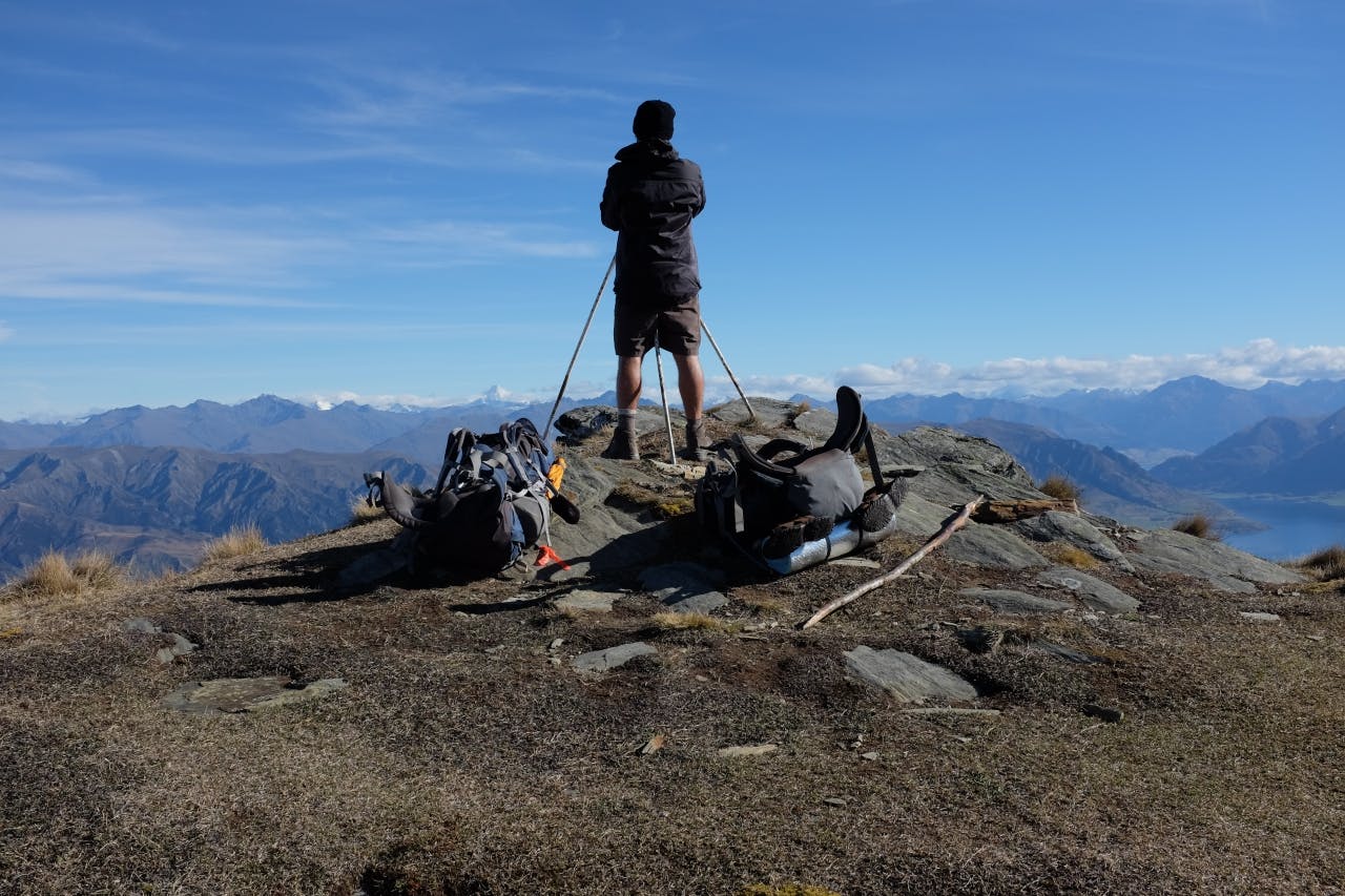
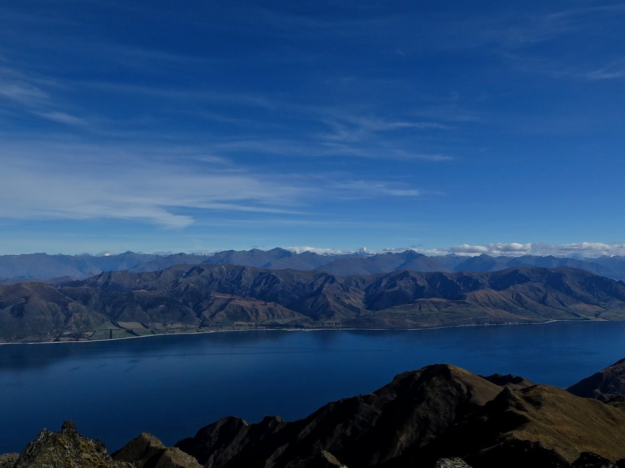
Breast Hill overlooking Lake Hawea and snow-capped peaks in Mt Aspiring National Park. Photo: Ben Curran
The uphill slog was brutal, and not just because I was recovering from injury. Even Ben had his moments.
“Are you kidding me?” he asked the earth more than once. The two-kilometre climb almost straight up from the riverbed is one of the most brutal of Te Araroa. Don’t look up, I told myself as I painstakingly staggered to the top, using trees to drag myself up some sections.
Stodys Hut is a timeworn, corrugated iron musterer’s hut at the edge of the forest and to say it was a welcome sight would be a gross understatement. I collapsed onto the bottom bunk while Ben went to collect wood for the giant open fireplace. I couldn’t help thinking how glad I was that we didn’t attempt this section the day before.
That night we got the most furious fire going and I scorched one of my socks that was drying on a wire clothesline. We relaxed by the flames with food, books and mugs of hot Raro. This ramshackle, dirt floor shelter was popular with hikers and, in these moments, I could see why.
Soon after falling asleep, however, we were awoken by a shuffling noise. I sprang up and shone my head lamp around the hut.
“Did you hear that?” I asked Ben.
He reckoned it was a mouse. I made a racket and tried to go back to sleep, but then the tiny footsteps started again. I shone my light and shook my pack noisily. This routine repeated at least half a dozen times during the night. At one point I heard the audacious little buggers scampering over my pack, which was right by my head.
“We can’t let them win,” Ben said sleepily. But they did win.
I just have to last the day, I told myself the next morning as we made our way along an old farm track towards Breast Hill. The sky was clear and a crisp breeze whispered through the amber grasses. This section of track was only opened in 2011 following tenure review on Lake Hawea Station.
From the top of Breast Hill, 1578m, we were treated to expansive views of a sparkling Lake Hawea and the snow-capped peaks of Mt Aspiring National Park. I exhaled long and hard and felt that unspeakable awe – the kind that silences you, grounds you in the moment – wash over me. “This makes it all worth it,” I said.
From Breast Hill we followed the fence line along an unformed trail to the eight-bunk Pakituhi Hut for lunch. I ate slowly, knowing that the last section of track – a savage 950m descent to the road – was, by all accounts, the worst. I limped and lurched down the rocky ridge like a man 40 years my senior. In fact, on our way down we met a group of white-haired men, who must have been in their late 60s, early 70s, making their way up and I swear I looked like I was having a worse time than they were.
Ben’s patience must have been wearing thin, but he never once showed it. The trail finally zigzagged down a steep face to Timaru River Rd where I crumpled onto a grass verge across from the lake. The plan was to hitch a ride to Wanaka that evening, but no vehicles on the isolated gravel road were stopping for a couple of filthy, bearded backpackers.
“What d’ya reckon?” Ben asked.
“Better start walking, I guess.”
